Belluton | Publow | |
Stanton Drew | ![]() ![]() ![]() ![]() | |
Stanton Wick | Chelwood |
Pensford is the largest village in the civil parish of Publow in Somerset, England. It lies in the Chew Valley, approximately 7 miles (11 km) south of Bristol, 8 miles (13 km) west of Bath, and 14 miles (23 km) north of Wells. It is on the A37 road from Bristol to Shepton Mallet.
Pensford was identified as being of special architectural and historic interest and was designated as a Conservation Area in May 1988. [1]
The name Pensford is in all likelihood derived from Brythonic Penffordd, meaning roughly 'top of the road' or 'the highest or furthest point of the road'. Alternatively, it may mean 'The animal pens by the ford' from the Old English pens and ford. [2]
The parish of Pensford was part of the Keynsham Hundred, [3]
During the 14th to 16th centuries Pensford was a cloth centre based on local wool. [4]
On 24 June 1685 rebel forces camped at Pensford during the Monmouth Rebellion. [5]
During the 19th and 20th centuries, the main industry was coal mining, with Pensford and the surrounding area forming a major part of the Somerset coalfield. Pensford and Bromley Collieries Ltd opened Pensford colliery to mine the Pensford syncline in 1909. By 1947, the mines output was 70,000 tons per annum. The colliery was connected by a spur of the North Somerset Railway .
The mine was prone to flooding and coal dust explosions. In 1931, Parliament discussed the safety record of the Somerset coalfield showing that between 1927 and 1930, 206 minors were injured in accidents, and 2 minors died at the colliery. In the early 1920s, the Minors Welfare Institute was founded and paid for by the miners. The Institute helped widows and held benevolent events.
The mine was deemed uneconomical and closed in 1955. Its sight was used as the depot for Filer's Coaches and was later converted to residential property. [6] [7] [8]
The River Chew suffered a major flood in 1968 with serious damage to towns and villages along its route. The flood swept away the bridge over the A37 and damaged the railway viaduct so badly that it never reopened. [9] On 10–11 July, a storm brought heavy rainfall to the valley, with 175 millimetres (7 in) falling in 18 hours on Chew Stoke, double the area's average rainfall for the whole of July. [10] [11]
Pensford and Publow has its own parish council which has some responsibility for local issues, including setting an annual precept (local rate) to cover the council's operating costs and producing annual accounts for public scrutiny. The parish council evaluates local planning applications and works with the local police, district council officers, and neighbourhood watch groups on matters of crime, security, and traffic. The parish council's role also includes initiating projects for the maintenance and repair of parish facilities, such as the village hall or community centre, playing fields and playgrounds, as well as consulting with the district council on the maintenance, repair, and improvement of highways, drainage, footpaths, public transport, and street cleaning. Conservation matters (including trees and listed buildings) and environmental issues are also of interest to the council.
It is part of the Publow and Whitchurch Ward which is represented by one councillor on the Bath and North East Somerset Unitary Authority which was created in 1996, as established by the Local Government Act 1992. It provides a single tier of local government with responsibility for almost all local government functions within its area including local planning and building control, local roads, council housing, environmental health, markets and fairs, refuse collection, recycling, cemeteries, crematoria, leisure services, parks, and tourism. It is also responsible for education, social services, libraries, main roads, public transport, trading standards, waste disposal and strategic planning, although fire, police and ambulance services are provided jointly with other authorities through the Avon Fire and Rescue Service, Avon and Somerset Constabulary, and the Great Western Ambulance Service.
Bath and North East Somerset's area covers part of the ceremonial county of Somerset but it is administered independently of the non-metropolitan county. Its administrative headquarters is in Bath. Between 1 April 1974 and 1 April 1996, it was the Wansdyke district and the City of Bath of the county of Avon. [12] Before 1974 that the parish was part of the Clutton Rural District. [13]
The village falls within the Publow and Whitchurch electoral ward. From Pensford the ward strikes north to end at Whitchurch on the Bristol border. The total population of this ward taken from the 2011 census was 2,473. [14]
The parish is represented in the House of Commons of the Parliament of the United Kingdom as part of North East Somerset and Hanham. [15] It elects one Member of Parliament (MP) by the first past the post system of election.
According to the 2001 Census, the Publow and Whitchurch Ward (which includes Belluton and Publow), had 1,087 residents, living in 429 households, with an average age of 40.8 years. Of these 73% of residents describing their health as 'good', 24% of 16- to 74-year-olds had no qualifications; and the area had an unemployment rate of 2.3% of all economically active people aged 16–74. In the Index of Multiple Deprivation 2004, it was ranked at 26,408 out of 32,482 wards in England, where 1 was the most deprived LSOA and 32,482 the least deprived. [16]
First built in the 14th century, the St Thomas à Becket Church is a Grade II* listed building [17]
Following damage in the 1968 floods the church was deconsecrated. During the 1980s an attempt was made to turn it into an arts centre but this was abandoned when the extent of the repairs required to make the building safe became clear. In 2007 the church was put on the market for redevelopment, [18] and in 2008 purchased for repair and use as a private dwelling. [19] The redevelopment of the church into a private dwelling was featured in the first episode of television series Restoration Home .
Pensford has an octagonal eighteenth-century village lock-up. [20] This is a Grade II listed building [21] and is a Scheduled Ancient Monument.
Pensford has three pubs: the Travellers Rest, the Rising Sun, and the George and Dragon. During the 17th and 18th centuries Pensford was an important staging post for stage coaches which stopped at the George and Dragon and the Rising Sun. [20] The George and Dragon dates from 1752 and is a Grade II listed building. [22]
The village's war memorial is also grade II listed and commemorates the seven people from the village who died in each of World War I and World War II. It is a wheel cross, with a Celtic-style carving. [31]
For centuries Pensford has been an important crossing point on the River Chew. The modern road bridge was rebuilt in 1968 after flood damage, but the much older (1839–85) bridge, by the church, survived the flood.
On the western side of the village is Pensford Viaduct on the disused Bristol and North Somerset Railway, built in 1873 but closed to trains in 1968 after the great flood of Pensford, after which it was deemed unsafe. The last passenger train had been earlier: the 9:25 a.m. from Frome to Bristol on 31 October 1959; after that there were only goods trains (mainly bringing coal from Radstock), which ceased in 1964, and very occasional excursion trains. Pensford viaduct is 995 feet (303 m) long, reaches a maximum height of 95 feet (29 m) to rail level and consists of sixteen arches. The viaduct is now a Grade II listed building.
Nearby is Lord's Wood, Pensford, and the village is on the route of the Monarch's Way long-distance footpath.
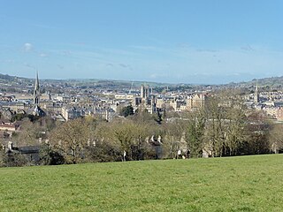
Bath and North East Somerset (B&NES) is a unitary authority district in Somerset, South West England. Bath and North East Somerset Council was created on 1 April 1996 following the abolition of the county of Avon. It is part of the ceremonial county of Somerset.
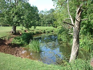
The River Chew is a small river in England that flows for some 17 miles (27 km) through the North Somerset countryside to form the Chew Valley before merging with the River Avon.
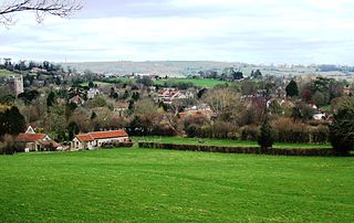
Chew Stoke is a small village and civil parish in the affluent Chew Valley, in Somerset, England, about 8 miles (13 km) south of Bristol and 10 miles north of Wells. It is at the northern edge of the Mendip Hills, a region designated by the United Kingdom as an Area of Outstanding Natural Beauty, and is within the Bristol and Bath green belt. The parish includes the hamlet of Breach Hill, which is approximately 2 miles (3.2 km) southwest of Chew Stoke itself.
North East Somerset was a constituency represented in the House of Commons of the UK Parliament from 2010 to 2024. For the whole of its existence its Member of Parliament (MP) was Jacob Rees-Mogg of the Conservative Party.
Belluton is a village in Somerset, England. It is in the district of Bath and North East Somerset and is located due south of the city of Bristol and due west of the city of Bath. The eastern end of the village is defined by the A37 road.
Newton St Loe is a small Somerset village and civil parish located close to the villages of Corston and Stanton Prior, between Bath and Bristol in England. The majority of the village is owned by the Duchy of Cornwall. The parish has a population of 681.
Bishop Sutton is a village on the northern slopes of the Mendip Hills, within the affluent Chew Valley in Somerset. It lies east of Chew Valley Lake and north east of the Mendip Hills, approximately ten miles south of Bristol on the A368, Weston-super-Mare to Bath road. Bishop Sutton and the neighbouring village of Stowey form the civil parish of Stowey Sutton.
Clutton is a village and civil parish on the eastern edge of the Chew Valley, close to the Cam Brook river, in the Bath and North East Somerset Council area, within the ceremonial county of Somerset, England. The village lies east of the A37 road between Bristol and Shepton Mallet, and west of the A39 between Bath and Wells. It is 9 miles (14 km) from Bristol and Bath, and 11 miles (18 km) from Wells. Close by are the villages of Temple Cloud and High Littleton. The town of Midsomer Norton is 5 miles (8 km) away. The parish, which includes the hamlets of Clutton Hill and Northend, had a population of 1,602 in 2011.
The Chew Valley is an affluent area in North Somerset, England, named after the River Chew, which rises at Chewton Mendip, and joins the River Avon at Keynsham. Technically, the area of the valley is bounded by the water catchment area of the Chew and its tributaries; however, the name Chew Valley is often used less formally to cover other nearby areas, for example, Blagdon Lake and its environs, which by a stricter definition are part of the Yeo Valley. The valley is an area of rich arable and dairy farmland, interspersed with a number of villages.
Ubley is a small village and civil parish within the Chew Valley in Bath and North East Somerset about 9 miles (14.5 km) south of Bristol. It is just south-east of Blagdon Lake, just off the A368 between Compton Martin and Blagdon.
Norton Malreward is a small Somerset village and civil parish 4 miles (6.4 km) south of Bristol, England at the northern edge of the Chew Valley. In 1895 Norton Malreward was combined with the neighbouring hamlet of Norton Hawkfield into a single parish, which has a population of 246.
High Littleton is a village and civil parish in Somerset, England, about 1.2 miles (1.9 km) north of Paulton and 7.5 miles (12 km) south-west of Bath. The parish includes the small village of Hallatrow and the hamlets of White Cross, Greyfield and Mearns; the northeastern part of High Littleton village is known as Rotcombe.
Publow is a small village and civil parish in Bath and North East Somerset, England. It lies beside the River Chew in the Chew Valley. It is 7 miles from Bristol, 9 miles from Bath, and 4 miles from Keynsham. The principal settlement in the parish is Pensford. The parish also includes the village of Belluton and part of the village of Woollard. At the 2011 census it had a population of 1,119.
Woollard is a small village on the River Chew in the affluent Chew Valley in England. It is in the Bath and North East Somerset council area and the ceremonial county of Somerset. The village is 7 miles (11 km) from Bristol, 9 miles (14 km) from Bath, and 4 miles (6.4 km) from Keynsham.
Stanton Drew is a small village and civil parish within the Chew Valley in Somerset, England, lying north of the Mendip Hills, 8 miles (13 km) south of Bristol, just off the A368 between Chelwood and Bishop Sutton in the area of the Bath and North East Somerset unitary authority.
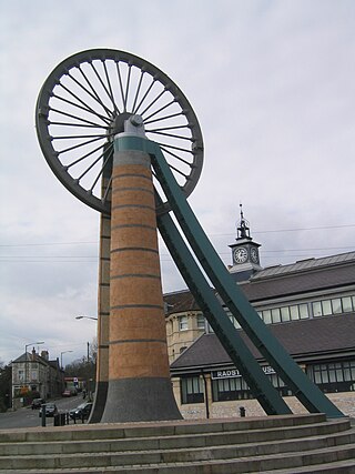
The Somerset Coalfield in northern Somerset, England is an area where coal was mined from the 15th century until 1973. It is part of a larger coalfield which stretched into southern Gloucestershire. The Somerset coalfield stretched from Cromhall in the north to the Mendip Hills in the south, and from Bath in the east to Nailsea in the west, a total area of about 240 square miles (622 km2). Most of the pits on the coalfield were concentrated in the Cam Brook, Wellow Brook and Nettlebridge Valleys and around Radstock and Farrington Gurney. The pits were grouped geographically, with clusters of pits close together working the same coal seams often under the same ownership. Many pits shared the trackways and tramways which connected them to the Somerset Coal Canal or railways for distribution.
The Bristol and North Somerset Railway was a railway line in the West of England that connected Bristol with Radstock, through Pensford and further into northern Somerset, to allow access to the Somerset Coalfield. The line ran almost due south from Bristol and was 16 miles (26 km) long.
St Thomas à Becket Church in Pensford, Somerset southwest England, dates from the 14th century, active in 1341, although only the tower remains from that date, the rest of the church having been rebuilt in 1868 by Giles and Robinson Architects and the church was reconsecrated in 1869.
Keynsham Abbey in Keynsham, Somerset, England, was a monastic abbey founded c. 1166 by William, Earl of Gloucester. The abbey was established as a house of Augustinian canons regular, and operated until the dissolution of the monasteries in 1539.
Pensford Viaduct is a disused railway bridge in the village of Pensford, within the historic English county of Somerset, now unitary authority Bath and North East Somerset. It is a Grade II listed building.