The Gloucestershire Wildlife Trust is the Gloucestershire local partner in a conservation network of 46 Wildlife Trusts. The Wildlife Trusts are local charities with the specific aim of protecting the United Kingdom's natural heritage. The Gloucestershire Wildlife Trust is managed by a board of trustees elected from its membership who provide overall direction for the development of the trust and there are advisory committees. The work of the trust is carried out through staff and volunteers.

The Cotswold Water Park is the United Kingdom's largest marl lake system, straddling the Wiltshire–Gloucestershire border, north-west of Cricklade and south of Cirencester. There are 180 lakes, spread over 42 square miles (110 km2).

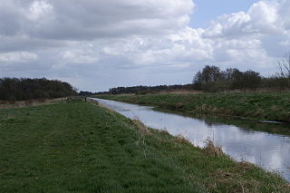
Coombe Hill Canal lies in the Vale of Gloucester, south west England, north of Leigh and runs west 2.75 miles (4.43 km) from Coombe Hill Basin to the River Severn near Wainlode Hill. It opened in 1796 and closed 80 years later in 1876, after the only lock was damaged by flooding. The Gloucestershire Wildlife Trust purchased the Coombe Hill Canal nature reserve in 1985 and the area is managed by the trust. Adjacent to the Coombe Hill Canal is a large area of wet meadowland situated midway between Gloucester and Tewkesbury to the west of the A38, which was purchased by the trust in 1999. There is a north and a south meadow. This land and the Canal itself often flood in winter, which attracts hundreds of wildfowl.

Lower Woods is a 280.1-hectare (692-acre) biological and geological Site of Special Scientific Interest near the village of Wickwar, South Gloucestershire, notified in 1966 and renotified in 1985. The site area has increased at last revision in 1974 to a 284.1-hectare (702-acre) site. The site is a nature reserve managed by the Gloucestershire Wildlife Trust.

Catcott, Edington and Chilton Moors SSSI is a 1083 hectare biological Site of Special Scientific Interest in Somerset, England notified in 1967. It is close to the villages of Edington and Catcott.

Midger is a 65.7-hectare (162-acre) biological Site of Special Scientific Interest straddling the border of Gloucestershire and South Gloucestershire, notified in 1966 and renotified in 1984. Since the last revision in 1974, the size has been reduced to a 56-hectare (140-acre) site. It lies east of Hillesley, Gloucestershire and north of Hawkesbury Upton, South Gloucestershire. It is at the head of the Kilcott Valley.
Shapwick Heath is a 394.0-hectare biological Site of Special Scientific Interest and national nature reserve between Shapwick and Westhay in Somerset, notified in 1967. It is part of the Brue Valley Living Landscape conservation project. The project commenced in January 2009 and aims to restore, recreate and reconnect habitat. It aims to ensure that wildlife is enhanced and capable of sustaining itself in the face of climate change while guaranteeing farmers and other landowners can continue to use their land profitably. It is one of an increasing number of landscape scale conservation projects in the UK.

Ashleworth Ham is a 104.73-hectare (258.8-acre) biological Site of Special Scientific Interest. It is a large area of grassland on the Severn floodplain, north of Ashleworth in Gloucestershire, England. It is registered as a Site of Special Scientific Interest and was notified in 1974 and renotified in 1985. Ashleworth Ham received this designation because it is one of three sites in the Severn Vale where migratory waterfowl winter.
Redlake Meadows & Hoggs Moor is a Site of Special Scientific Interest (SSSI), noted for its biological characteristics, in Cornwall, England, UK. Within the SSSI is Redlake Cottage Meadows nature reserve owned by the Cornwall Wildlife Trust.
Gwent Wildlife Trust (GWT) is a wildlife trust covering the area between the lower Wye and Rhymney rivers which forms the vice county of Monmouthshire in south-east Wales. It is a registered charity and a member of the Wildlife Trusts Partnership.

The Tamar–Tavy Estuary is a Site of Special Scientific Interest (SSSI) covering the tidal estuaries of the River Tamar and the River Tavy on the border between Cornwall and Devon in England, UK. Part of the Tamar estuary also forms the Tamar Estuary Nature Reserve, owned by the Cornwall Wildlife Trust. The site was designated in 1991 for its biodiversity and varying habitats that support many wader and wildfowl species, as well as the special interest of its marine biology.

Rosenannon Downs is a nature reserve in mid Cornwall, England, UK, being designated Rosenannon Bog and Downs Site of Special Scientific Interest (SSSI), noted for its biological characteristics. The site supports a wide variety of flora and fauna and includes Bronze Age barrows. Conservation work is carried out on the site by the owners, the Cornwall Wildlife Trust.

Brassey is a 2.1-hectare (5.2-acre) biological Site of Special Scientific Interest in Gloucestershire, notified in 1954 and renotified in 1983. It is situated on the north side of the Windrush Valley, midway between Naunton and Upper Slaughter. The reserve comprises sloping, unimproved limestone pasture. There is a fast-flowing stream. This site is one of the few freshwater marshes in Gloucestershire. The stream joins the River Windrush.
Chaceley Meadow is a 1.8-hectare (4.4-acre) biological Site of Special Scientific Interest in Gloucestershire, notified in 1954 and renotified in 1993. It lies on the eastern edge of Chaceley village and is about half a mile west of the River Severn.

Box Farm Meadows (Stuart Fawkes reserve) (grid reference ST865997) is a 8.3-hectare (21-acre) biological Site of Special Scientific Interest in Gloucestershire, notified in 1985. This was formerly known as Balls Green Pastures. The reserve is situated at the southern edge of Box village and one mile east of Nailsworth.

Barnby Broad and Marshes is a Site of Special Scientific Interest (SSSI) in the Waveney district of the English county of Suffolk. The site is 189.6 hectares in size. It is in the parishes of North Cove and Barnby, located between Beccles and Lowestoft in the north of the county. The site is bordered on its southern edge by the East Suffolk railway line and to the north by the River Waveney. It is a Special Area of Conservation, a Special Protection Area under the EC Birds Directive, and a Ramsar internationally important wetland site. There are two Suffolk Wildlife Trust nature reserves in the site, Castle Marshes and North Cove.
Clarke's Pool Meadow is a 1.8-hectare (4.4-acre) biological Site of Special Scientific Interest in Gloucestershire, notified in 1997. It lies on the flat top of 'Old Hill' about half a mile south of Blakeney. The site consists of two fields which were purchased by the Gloucestershire Wildlife Trust in 1997. The site was designated an SSSI in the same year and it is one of the finest surviving traditional hay meadows in Gloucestershire.

Salmonsbury Meadows is an 18-hectare (44-acre) biological and geological Site of Special Scientific Interest in Gloucestershire, notified in 1985. The site is listed in the 'Cotswold District' Local Plan 2001-2011 as a Key Wildlife Site (KWS).

Sapperton Valley is a 3.7-hectare (9.1-acre) nature reserve near Chalford in the Stroud district of Gloucestershire, England. The site is managed by the Gloucestershire Wildlife Trust under leasing arrangements with the Bathurst Estate, in place since 1964.

