Charterhouse may refer to:
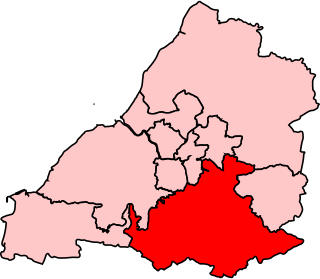
Wansdyke was a county constituency represented in the House of Commons of the Parliament of the United Kingdom. It elected one Member of Parliament (MP) by the first past the post system of election.

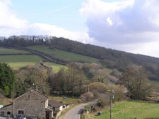
Wellow is a village and civil parish in Somerset, England, about 5 miles (8.0 km) south of Bath. The parish, which includes the hamlets of Twinhoe, White Ox Mead, Baggridge and part of Midford has a population of 529. The village itself falls within the southernmost boundary of the Cotswolds Area of Outstanding Natural Beauty and is recognised as having special architectural and historic interest, which led to it being designated as a Conservation Area in 1983.

Limpley Stoke is a village and civil parish in Wiltshire, England. It is in the Avon valley, between Bath and Freshford and is both above and below the A36 road.
The Chew Valley is an area in North Somerset, England, named after the River Chew, which rises at Chewton Mendip, and joins the River Avon at Keynsham. Technically, the area of the valley is bounded by the water catchment area of the Chew and its tributaries; however, the name Chew Valley is often used less formally to cover other nearby areas, for example, Blagdon Lake and its environs, which by a stricter definition are part of the Yeo Valley. The valley is an area of rich arable and dairy farmland, interspersed with a number of villages.
Congrove Field and The Tumps is a is a 12.5 hectare biological Site of Special Scientific Interest (SSSI) on Lansdown Hill, north of Bath in Bath and North East Somerset, notified in 1991.
Hinton Charterhouse Pit is a 0.4 hectare geological Site of Special Scientific Interest near the village of Hinton Charterhouse, Bath and North East Somerset, notified in 1971.
Hinton Hill, Wellow is a 0.25 hectare geological Site of Special Scientific Interest (SSSI) near the village of Wellow in Somerset, notified in 1996.

Long Dole Wood and Meadows SSSI is a 9.8 hectares biological Site of Special Scientific Interest (SSSI) between the villages of Farrington Gurney and Hinton Blewitt in Bath and North East Somerset, notified in 1987.

The Cheddar Complex is a 441.3 hectare biological Site of Special Scientific Interest near Cheddar around the Cheddar Gorge and north east to Charterhouse in the Mendip Hills, Somerset, England, notified in 1952.

Hinton Charterhouse is a small village and civil parish in the Bath and North East Somerset unitary authority, Somerset, England. The parish, which includes the village of Midford, has a population of 515.

The Friary is a small hamlet outside the English village of Freshford, about 6 miles (10 km) south of Bath, Somerset. Although closer to Freshford it lies within the parish of Hinton Charterhouse.

Cherry Hinton Pit is a 12.8 hectare biological Site of Special Scientific Interest (SSSI) on the south-eastern outskirts of Cambridge. The site consists of East Pit and most of the smaller West Pit. East Pit is part of the Limekiln Close and East Pit Local Nature Reserve, which is managed by the Wildlife Trust for Bedfordshire, Cambridgeshire and Northamptonshire under the name Cherry Hinton Chalk Pits. West Pit is a separate Local Nature Reserve (LNR).

Hinton Priory was a Carthusian monastery in northeast Somerset, England, from 1232 until 1539.

The George Inn in Norton St Philip, Somerset, England, one of a number of establishments that claims to be Britain’s oldest tavern, is located in the centre of the village. It was built in the 14th or 15th century and has been designated as a Grade I listed building.
Bathavon was a rural district in Somerset, England, from 1933 to 1974.
Captain Charles Talbot Foxcroft was a British Conservative Party politician. He was Member of Parliament (MP) for Bath from 1918 to 1923, and from 1924 until his death.

The Church of St John the Baptist is an Anglican parish church in Hinton Charterhouse, Somerset, England. It was built in the 12th century and has been designated as a Grade II* listed building.
Abel Moysey, of Hinton Charterhouse, Somerset, was an English lawyer and politician who sat in the House of Commons from 1774 to 1790.
Hinton House in Hinton Charterhouse, Somerset, England was built around 1700. It is a Grade II* listed building.
