
The River Avon is an English river in the south west of the country. To distinguish it from a number of other rivers of the same name, this river is often also known as the Bristol Avon. The name 'Avon' is a cognate of the Welsh word afon, meaning 'river'.
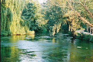
The River Test is a chalk stream in Hampshire in the south of England. It rises at Ashe near Basingstoke and flows southwards for 40 miles (64 km) to Southampton Water. Settlements on the Test include the towns of Stockbridge and Romsey. Below the village of Longparish, the river is followed by the Test Way, a long-distance footpath.
The River Stour is a 61 mi (98 km) river which flows through Wiltshire and Dorset in southern England, and drains into the English Channel. The catchment area for the river and its tributaries is listed as being 480 square miles (1,240 km2).

The Somerset Coal Canal was a narrow canal in England, built around 1800. Its route began in basins at Paulton and Timsbury, ran to nearby Camerton, over two aqueducts at Dunkerton, through a tunnel at Combe Hay, then via Midford and Monkton Combe to Limpley Stoke where it joined the Kennet and Avon Canal. This link gave the Somerset coalfield access east toward London. The longest arm was 10.6 miles (17.1 km) long with 23 locks. From Midford an arm also ran via Writhlington to Radstock, with a tunnel at Wellow.
The River Frome is a river in Somerset, England. It rises near Bungalow Farm on Cannwood Lane, south-west of Witham Friary, flows north through Blatchbridge to the town of Frome, and continues in a generally northerly direction passing between the eastern edge of the Mendip Hills and Trowbridge before joining the Bristol Avon at Freshford, below Bradford on Avon.

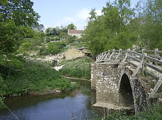
Midford is a village approximately 3 miles (5 km) south-south-east of Bath, Somerset, England. Although relatively small, it extends over 2 counties, is part of two unitary authorities and is part of five parishes. Although all five parishes extend very near to the village centre, most of the residents reside in the parish of Southstoke and are part of the Bath and North East Somerset unitary authority.

Wellow is a village and civil parish in Somerset, England, about 5 miles (8.0 km) south of Bath. The parish, which includes the hamlets of Twinhoe, White Ox Mead, Baggridge and part of Midford has a population of 529. The village itself falls within the southernmost boundary of the Cotswolds Area of Outstanding Natural Beauty and is recognised as having special architectural and historic interest, which led to it being designated as a Conservation Area in 1983.

This River Blackwater drains small parts of the English counties of Hampshire and Wiltshire. It is a tributary of the River Test.
The River Nadder is a tributary of the River Avon, flowing in south Wiltshire, England.
The Cam brook is a small river in Somerset, England. It rises near Hinton Blewitt, flows through Cameley, Temple Cloud, Camerton, Dunkerton and Combe Hay. It then joins the Wellow Brook at Midford to form Midford Brook before joining the River Avon close to the Dundas Aqueduct.

The Wellow Brook is a small river in Somerset, England.

The River Somer is a small river in Somerset, England.

Bashall Brook is a minor river in Lancashire, England. It is 7.09 miles (11.41 km) long and has a catchment area of 6.86 square miles (1,777.68 ha).

The Limestone Link is a 36-mile (58 km) long-distance footpath in England, from the Mendip Hills in Somerset to Cold Ashton in Gloucestershire. It is marked by an ammonite waymarker.

The River Wey is a tributary of the River Thames in south east England. Its two branches, one of which rises near Alton in Hampshire and the other in West Sussex to the south of Haslemere, join at Tilford in Surrey. Once combined the flow is eastwards then northwards via Godalming and Guildford to meet the Thames at Weybridge. Downstream the river forms the backdrop to Newark Priory and Brooklands. The Wey and Godalming Navigations were built in the 17th and 18th centuries, to create a navigable route from Godalming to the Thames.

The Lam Brook is a stream in the West Country of England, which rises in a number of springs on the southern end of the Cotswold Hills and runs in a generally southerly direction for approximately 2.5 miles (4.0 km) before joining the river Avon at Lambridge in Bath. The brook is mentioned in an Anglo-Saxon charter of indeterminate date. There is evidence of watermills in the Swainswick valley but no working examples survive. The waters are relatively clean and support a variety of wildlife including the rare white-clawed crayfish.

The Tetbury Avon, also known as the Little Avon or the Ingleburn, is a tributary of the Bristol Avon. It is also referred to as the River Avon . It rises at Tetbury in Gloucestershire in the West Country of England, and flows in a generally south easterly direction, joining the Sherston Avon at Malmesbury in Wiltshire. The water flow has been reduced by public water extraction from its source aquifer in the Cotswold Hills. In the past watermills were used for fulling wool and grinding corn. One working mill survives.

The River Swift is a 14-mile (23 km) long tributary of the River Avon that rises in south Leicestershire, and flows through the town of Lutterworth before joining the Avon at its confluence at Rugby in Warwickshire in the English Midlands.

The Hilton Brook or Sutton Brook is a tributary of the River Dove in Derbyshire, England, and is 26 kilometres long. Like many watercourses in the area, it has multiple names, often being named locally after the village it flows past.

Fleet Brook is a small river in northern Hampshire, England and tributary of the River Hart.
