
The River Parrett flows through the counties of Dorset and Somerset in South West England, from its source in the Thorney Mills springs in the hills around Chedington in Dorset. Flowing northwest through Somerset and the Somerset Levels to its mouth at Burnham-on-Sea, into the Bridgwater Bay nature reserve on the Bristol Channel, the Parrett and its tributaries drain an area of 660 square miles (1,700 km2) – about 50 per cent of Somerset's land area, with a population of 300,000.

Glastonbury is a town and civil parish in Somerset, England, situated at a dry point on the low-lying Somerset Levels, 23 miles (37 km) south of Bristol. The town, which is in the Mendip district, had a population of 8,932 in the 2011 census. Glastonbury is less than 1 mile (2 km) across the River Brue from Street, which is now larger than Glastonbury.

Glastonbury Festival is a five-day festival of contemporary performing arts that takes place in Pilton, Somerset, England. In addition to contemporary music, the festival hosts dance, comedy, theatre, circus, cabaret, and other arts. Leading pop and rock artists have headlined, alongside thousands of others appearing on smaller stages and performance areas. Films and albums have been recorded at the festival, and it receives extensive television and newspaper coverage.

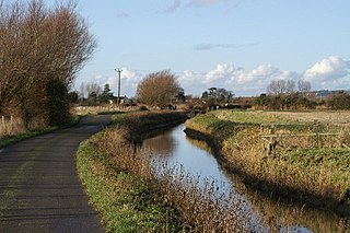
The Somerset Levels are a coastal plain and wetland area of Somerset, England, running south from the Mendips to the Blackdown Hills.

Street is a large village and civil parish in Somerset, England, with a population of 11,805 in 2011. On a dry spot in the Somerset Levels, at the end of the Polden Hills, it is 2 miles (3.2 km) south-west of Glastonbury. There is evidence of Roman occupation. Much of the history of the village is dominated by Glastonbury Abbey, and a 12th-century causeway from Glastonbury built to transport local Blue Lias stone to it.

Athelstan Joseph Michael Eavis is an English dairy farmer and the co-creator of the Glastonbury Festival, which takes place at his farm in Pilton, Somerset.

Glastonbury Abbey was a monastery in Glastonbury, Somerset, England. Its ruins, a grade I listed building and scheduled ancient monument, are open as a visitor attraction.

The Sweet Track is an ancient trackway, or causeway, in the Somerset Levels, England, named after its finder, Ray Sweet. It was built in 3807 BC and is the second-oldest timber trackway discovered in the British Isles, dating to the Neolithic. It is now known that the Sweet Track was predominantly built along the course of an earlier structure, the Post Track.
The Glastonbury Canal ran for approximately 14 miles (23 km) through two locks from Glastonbury to Highbridge in Somerset, England, where it entered the River Parrett and from there the Bristol Channel. The canal was authorised by Parliament in 1827 and opened in 1834. It was operated by The Glastonbury Navigation & Canal Company. Most of it was abandoned as a navigation in 1854, when a railway was built along the towpath.

The River Brue originates in the parish of Brewham in Somerset, England, and reaches the sea some 50 kilometres (31 mi) west at Burnham-on-Sea. It originally took a different route from Glastonbury to the sea, but this was changed by Glastonbury Abbey in the twelfth century. The river provides an important drainage route for water from a low-lying area which is prone to flooding which man has tried to manage through rhynes, canals, artificial rivers and sluices for centuries.

Westhay Moor is a 513.7-hectare (1,269-acre) biological Site of Special Scientific Interest 2.5 kilometres (1.6 mi) north-east of Westhay village and 4 kilometres (2.5 mi) from Wedmore in Somerset, England, notified in 1971. Westhay Moor is also notified as part of the Somerset Levels and Moors Special Protection Area under the EU Birds Directive and as a Ramsar site, and a National Nature Reserve.
Meare Pool was a lake in the Somerset Levels in South West England. Lake villages existed there in prehistoric times. During medieval times it was an important fishery, but following extensive drainage works it had disappeared from maps in the eighteenth century.
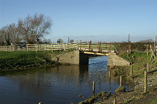
The medieval Glastonbury canal was built in about the middle of the 10th century to link the River Brue at Northover with Glastonbury Abbey, a distance of about 1.75 kilometres (1,900 yd). Its initial purpose is believed to be the transport of building stone for the abbey, but later it was used for delivering produce, including grain, wine and fish, from the abbey's outlying properties. It remained in use until at least the 14th century, but possibly as late as the mid-16th century. English Heritage assess the canal remains, based on a "provisional" interpretation, as a site of "national importance".

The Abbot's Fish House in Meare, Somerset, England, was built in the 14th century and has been designated as a Grade I listed building and Scheduled Ancient Monument. It is the only surviving monastic fishery building in England.

The Manor Farmhouse in Meare, Somerset, England, was built in the 14th century as the summer residence of the Abbots from Glastonbury Abbey and is now a farmhouse. Along with its outbuildings the farmhouse has been designated as a Grade I listed building.
The Mark Yeo is a short river or rhyne in north Somerset, England. It starts near Mark on the Somerset Levels and flows north for about 6 kilometres (4 mi) under the M5 motorway to join the River Axe near Loxton. It provided a link between the Axe and the River Brue, as part of a waterway called the "Pilrow Cut" probably canalised in the early 13th century. It no longer connects to the Brue, but is used for drainage purposes, which is unlikely to have been the case in the Middle Ages. Within the village of Mark, it is crossed by an iron bridge erected in 1824, which claims to be the oldest of its kind in the county.

Ham Wall is an English wetland National Nature Reserve (NNR) 4 kilometres (2.5 mi) west of Glastonbury on the Somerset Levels. It is managed by the Royal Society for the Protection of Birds (RSPB). Since the last Ice Age, decomposing plants in the marshes of the Brue valley in Somerset have accumulated as deep layers of peat that were commercially exploited on a large scale in the twentieth century. Consumer demand eventually declined, and in 1994 the landowners, Fisons, gave their old workings to what is now Natural England, who passed the management of the 260 hectares Ham Wall section to the RSPB.

The Yeovil Scarplands are a natural region in southern England in the counties of Somerset and Dorset.
The Avalon Marshes Partnership is a group of conservation organisations working together in the Somerset Levels. The members are Natural England,, the Royal Society for the Protection of Birds (RSPB), the Somerset Wildlife Trust the Hawk and Owl Trust, Historic England, South West Heritage Trust and the Environment Agency. Between 2012 and 2016 the scheme was supported by a Heritage Lottery Fund grant of £1,772,500 with additional investment of £920,080 from other sources. The Avalon Marshes Centre, run by Natural England, is near the Ham Wall reserve. The network of reserves and private land managed for conservation in the Avalon marshes means that wetland management can be carried out on a landscape scale.
