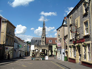
Shepton Mallet is a market town and civil parish in the Mendip District of Somerset, England, some 16 miles (26 km) south-west of Bath, 18 miles (29 km) south of Bristol and 5 miles (8.0 km) east of Wells. It had an estimated population of 10,810 in 2019. Mendip District Council is based there. The Mendip Hills lie to the north and the River Sheppey runs through the town, as does the route of the Fosse Way, the main Roman road between north-east and south-west England. There is evidence of Roman settlement. Its listed buildings include a medieval parish church. Shepton Mallet Prison was England's oldest, but closed in March 2013. The medieval wool trade gave way to trades such as brewing in the 18th century. It remains noted for cider production. It is the closest town to the Glastonbury Festival and nearby the Royal Bath and West of England Society showground.

The River Huntspill is an artificial river, in the Somerset Levels, in the Sedgemoor district of Somerset, England. It was built in 1940 to supply process water to ROF Bridgwater, and has resulted in reduced flooding of the lower Brue Valley. Huntspill Sluice at the river's western end, also known as West Huntspill Sluice, separates it from the River Parrett.

Mendip is a local government district of Somerset in England. The district covers a largely rural area of 285 square miles (738 km2) with a population of approximately 112,500, ranging from the Wiltshire border in the east to part of the Somerset Levels in the west. The district takes its name from the Mendip Hills which lie in its northwest. The administrative centre of the district is Shepton Mallet but the largest town is Frome.

Somerset is a rural county in the southwest of England, covering 4,171 square kilometres (1,610 sq mi). It is bounded on the north-west by the Bristol Channel, on the north by Bristol and Gloucestershire, on the north-east by Wiltshire, on the south-east by Dorset, and on the south west and west by Devon. It has broad central plains with several ranges of low hills. The landscape divides into four main geological sections from the Silurian through the Devonian and Carboniferous to the Permian which influence the landscape, together with water-related features.
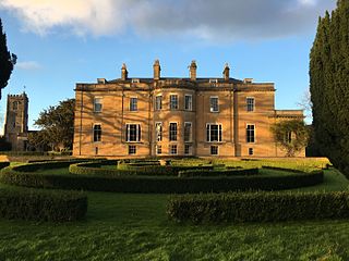
Dinder House, is a Somerset estate with a small country house Grade II Regency listed building in the village of Dinder, in the civil parish of St Cuthbert Out in Somerset. Dinder House was formerly a manor house dating back to the 12th century, but the existing building was constructed between 1799 and 1801 by the Rev William Somerville on the original site. The estate remained as the seat of the Somerville family until the late twentieth century.

Dinder is a small village 2½ miles west of Shepton Mallet, and 2 miles east of Wells in Somerset. It falls within the civil parish of St Cuthbert Out and the Mendip district.

The River Brue originates in the parish of Brewham in Somerset, England, and reaches the sea some 50 kilometres (31 mi) west at Burnham-on-Sea. It originally took a different route from Glastonbury to the sea, but this was changed by Glastonbury Abbey in the twelfth century. The river provides an important drainage route for water from a low-lying area which is prone to flooding which man has tried to manage through rhynes, canals, artificial rivers and sluices for centuries.

Westhay Moor is a 513.7-hectare (1,269-acre) biological Site of Special Scientific Interest 2.5 kilometres (1.6 mi) north-east of Westhay village and 4 kilometres (2.5 mi) from Wedmore in Somerset, England, notified in 1971. Westhay Moor is also notified as part of the Somerset Levels and Moors Special Protection Area under the EU Birds Directive and as a Ramsar site, and a National Nature Reserve.

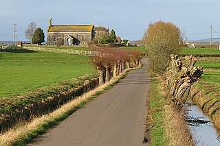
Doulting is a village and civil parish 1.5 miles (2 km) east of Shepton Mallet, on the A361, in the Mendip district of Somerset, England.
Godney is a village and civil parish near Glastonbury on the River Sheppey on the Somerset Levels in the Mendip district of Somerset, England.

Galton's Canal was a 1-mile 3 furlong (2.2 km) canal with one lock, crossing Westhay Moor in Somerset, England, and connecting the River Brue to the North Drain. It was operational by 1822, and ceased to be used after the 1850s.

Westhay is a village in Somerset, England. It is situated in the parish of Meare, 4 miles (6.4 km) north west of Glastonbury on the Somerset Levels, in the Mendip district.
Meare Pool was a lake in the Somerset Levels in South West England. Lake villages existed there in prehistoric times. During medieval times it was an important fishery, but following extensive drainage works it had disappeared from maps in the eighteenth century.
The medieval Glastonbury canal was built in about the middle of the 10th century to link the River Brue at Northover with Glastonbury Abbey, a distance of about 1.75 kilometres (1,900 yd). Its initial purpose is believed to be the transport of building stone for the abbey, but later it was used for delivering produce, including grain, wine and fish, from the abbey's outlying properties. It remained in use until at least the 14th century, but possibly as late as the mid-16th century. English Heritage assess the canal remains, based on a "provisional" interpretation, as a site of "national importance".

The Church of St Matthew in Wookey, Somerset, England, dates from the twelfth century and is a Grade I listed building.

The Mid Somerset Hills are a major natural region in the county of Somerset in southwest west England, forming a series of low hills and ridges that divide up the Somerset Levels.

St Aldhelm's Well in Doulting, Somerset, England, is an ancient spring which is the source of the River Sheppey. The site is a Grade II listed building, although it is a medieval site, most of what remains has been rebuilt.
The Avalon Marshes Partnership is a group of conservation organisations working together in the Somerset Levels. The members are Natural England,, the Royal Society for the Protection of Birds (RSPB), the Somerset Wildlife Trust the Hawk and Owl Trust, Historic England, South West Heritage Trust and the Environment Agency. Between 2012 and 2016 the scheme was supported by a Heritage Lottery Fund grant of £1,772,500 with additional investment of £920,080 from other sources. The Avalon Marshes Centre, run by Natural England, is near the Shapwick Heath reserve. The network of reserves and private land managed for conservation in the Avalon marshes means that wetland management can be carried out on a landscape scale.

