Clapton in Gordano

Last updated

Clapton in Gordano
Clapton-in-Gordano (Somerset) St Michael's Church - geograph.org.uk - 67569.jpg
St Michael's Church
Clapton Court - geograph.org.uk - 697226.jpg
Clapton Court
Somerset UK location map.svg
Red pog.svg
Clapton in Gordano
Location within Somerset
Population348 (2011) [1]
OS grid reference ST475740
Unitary authority
Ceremonial county
Region
Country England
Sovereign state United Kingdom
Post town BRISTOL
Postcode district BS20
Dialling code 01275
Police Avon and Somerset
Fire Avon
Ambulance South Western
UK Parliament
List of places
UK
England
Somerset
51°27′43″N2°45′29″W / 51.462°N 2.758°W / 51.462; -2.758

Clapton in Gordano is a village and civil parish in Somerset, England. It is situated within the unitary authority of North Somerset on the southern side of the Gordano Valley, immediately adjacent to the M5 motorway. The parish has a population of 348. [1] There is a village football club, Clapton in Gordano FC. They currently run two sides with a view to continue progressing throughout the leagues. Their home ground is currently Clapton Lane, Portishead.

Contents

History

The Black Horse Inn. The Black Horse Inn, Clapton-in-Gordano - geograph.org.uk - 1186769.jpg
The Black Horse Inn.

The name Gordano comes from Old English and is descriptive of the triangular shape of the whole valley from Clevedon to Portishead, [2] being the ablative singular of the Latinised form of Gorden meaning muddy valley. [3]

Roman coin hoards have been discovered in Clapton. The first discovery was in 1891 when 35 'third bras' coins were found at the top of Tickenham Hill. [4] The second hoard of about 3500 bronze coins was discovered between 1922 and 1924 in a field between the church and the rectory. Some of the coins are in the Museum of Somerset while the majority were sold to the Nicholson Museum in Australia in 1949. [5] [6]

The parish of Clapton was part of the Portbury Hundred. [7]

Coal was mined in the area in the 17th and 18th centuries. [6]

Half a mile west of the village is a manor house (now a farm). Another notable historic building in the village is The Black Horse pub, a 17th-century inn [8] and former magistrate's gaol.

Sperrings Farm with its 500-year-old listed farmhouse [9] is situated on the outskirts of the village.

Governance

The parish council has responsibility for local issues, including setting an annual precept (local rate) to cover the council’s operating costs and producing annual accounts for public scrutiny. The parish council evaluates local planning applications and works with the local police, district council officers, and neighbourhood watch groups on matters of crime, security, and traffic. The parish council's role also includes initiating projects for the maintenance and repair of parish facilities, such as playgrounds and dog fouling, as well as consulting with the district council on the maintenance, repair, and improvement of highways, drainage, footpaths, public transport, and street cleaning. Conservation matters (including trees and listed buildings) and environmental issues are also of interest to the council.

The parish falls within the unitary authority of North Somerset which was created in 1996, as established by the Local Government Act 1992. It provides a single tier of local government with responsibility for almost all local government functions within its area including local planning and building control, local roads, council housing, environmental health, markets and fairs, refuse collection, recycling, cemeteries, crematoria, leisure services, parks, and tourism. It is also responsible for education, social services, libraries, main roads, public transport, trading standards, waste disposal and strategic planning, although fire, police and ambulance services are provided jointly with other authorities through the Avon Fire and Rescue Service, Avon and Somerset Constabulary and the South Western Ambulance Service.

North Somerset's area covers part of the ceremonial county of Somerset but it is administered independently of the non-metropolitan county. Its administrative headquarters are in the town hall in Weston-super-Mare. Between 1 April 1974 and 1 April 1996, it was the Woodspring district of the county of Avon. [10] Before 1974 that the parish was part of the Long Ashton Rural District. [11]

The village falls in 'Gordano' electoral ward. The ward stretches from the east side of Portishead through Clapton in Gordano to Tickenham. The total ward population taken at the 2011 census was 4,315. [12]

The parish is represented in the House of Commons of the Parliament of the United Kingdom as part of the North Somerset constituency. It elects one Member of Parliament (MP) by the first past the post system of election, currently Liam Fox of the Conservative Party. It was also part of the South West England constituency of the European Parliament prior to Britain leaving the European Union in January 2020, which elected seven MEPs using the d'Hondt method of party-list proportional representation.

Geography

Near the village is Clapton Moor, 40 hectares of grassland owned and managed by the Avon Wildlife Trust.

Religious sites

The 13th century church is dedicated to St Michael. [13]

Landmarks

Clapton court was a mansion house and then a farmhouse. The northern elevation dates from the 15th century with the rest of the building dating from the 17th and 19th centuries. It has been designated as a Grade II listed building. [14] In 2009 planning permission was gained to demolish some of the farm buildings and convert others into holiday homes and offices. [15]

Notable residents

Related Research Articles

<span class="mw-page-title-main">North Somerset</span> District in England

North Somerset is a unitary authority in the ceremonial county of Somerset, England. The council is based in Weston-super-Mare, the area's largest town. The district also contains the towns of Clevedon, Nailsea and Portishead, along with a number of villages and surrounding rural areas. Some southern parts of the district fall within the Mendip Hills, a designated Area of Outstanding Natural Beauty.

<span class="mw-page-title-main">Portishead, Somerset</span> Town in Somerset, England

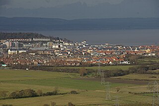
Portishead is a town and civil parish in the North Somerset unitary authority area, in the county of Somerset, England. The town has a population of 27,000 and is located next to the Severn Estuary opposite Cardiff and Newport in Wales. The town is 8 miles (13 km) to the west of Bristol and 18 miles northeast of Weston-super-Mare.

<span class="mw-page-title-main">Monkton Combe</span> Human settlement in England

Monkton Combe is a village and civil parish in north Somerset, England, 3 miles (4.8 km) south of Bath. The parish, which includes the hamlet of Tucking Mill, had a population of 554 in 2013. It was formerly known as Combe, owing to its geography, while it was also known as Monckton Combe and Combe Monckton until last century.

<span class="mw-page-title-main">Tickenham</span> Human settlement in England

Tickenham is a village and civil parish near Clevedon and Nailsea in North Somerset, England. The parish has a population of 910. It has a primary school, a village hall and a garden centre, but no shops, although it formerly had a post office.

<span class="mw-page-title-main">Easton in Gordano</span> Village in Somerset, England

Easton in Gordano is a village in Somerset, England, about 4+12 miles (7 km) northwest of Bristol city centre. It is part of the civil parish of Pill and Easton-in-Gordano and within the unitary authority of North Somerset. In 2011 the population of the parish was 4,828.

<span class="mw-page-title-main">Weston in Gordano</span> Human settlement in England

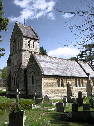
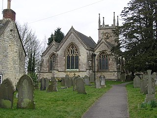
Weston in Gordano is a village and civil parish in Somerset, England. It is situated in the middle of the Gordano valley on the north side, and in the Unitary Authority of North Somerset, on the road between Clevedon and Portishead. The parish has a population of 301.

<span class="mw-page-title-main">Walton in Gordano</span> Human settlement in England

Walton in Gordano is a village and civil parish in North Somerset, England. It is situated in a small valley at the side of the south-western end of the Gordano Valley, about a mile from Clevedon. The parish has a population of 273.

<span class="mw-page-title-main">Portbury</span> Human settlement in England

Portbury is a village and civil parish in Somerset, England within the unitary authority of North Somerset. The parish includes the hamlet of Sheepway which is situated on the moorland at the northern edge of the Gordano valley, between the Gordano services on the M5 motorway and Portishead, near the Royal Portbury Dock. The parish has a population of 827.

<span class="mw-page-title-main">East Harptree</span> Human settlement in England

East Harptree is a village and civil parish in Somerset, England. It is situated 5 miles (8.0 km) north of Wells and 15 miles (24.1 km) south of Bristol, on the northern slope of the Mendip Hills overlooking the Chew Valley. The parish has a population of 644. The parish includes the hamlet of Coley.

Clutton is a village and civil parish on the eastern edge of the affluent Chew Valley, close to the Cam Brook river, in the Bath and North East Somerset Council area, within the ceremonial county of Somerset, England. The village lies east of the A37 road between Bath and Shepton Mallet, and is 9 miles (14 km) from Bristol and Bath, and 11 miles (18 km) from Wells. Close by are the villages of Temple Cloud and High Littleton. The town of Midsomer Norton is 5 miles (8 km) away. The parish, which includes the hamlets of Clutton Hill and Northend, had a population of 1,602 in 2011.

<span class="mw-page-title-main">Winford</span> Human settlement in England

Winford is a village and civil parish within the Chew Valley, Somerset, England. It is within the unitary authority of North Somerset about 8 miles (12.9 km) south of Bristol. The parish has a population of 2,153.

<span class="mw-page-title-main">High Littleton</span> Village in Somerset, England

High Littleton is a village and civil parish in Somerset, England, about 1.2 miles (1.9 km) north of Paulton and 7.5 miles (12 km) south-west of Bath. The parish includes the small village of Hallatrow and the hamlets of White Cross, Greyfield and Mearns; the northeastern part of High Littleton village is known as Rotcombe.

<span class="mw-page-title-main">Publow</span> Human settlement in England

Publow is a small village and civil parish in Bath and North East Somerset, England. It lies beside the River Chew in the Chew Valley. It is 7 miles from Bristol, 9 miles from Bath, and 4 miles from Keynsham. The principal settlement in the parish is Pensford. The parish also includes the village of Belluton and part of the village of Woollard. At the 2011 census it had a population of 1,119.

<span class="mw-page-title-main">Marksbury</span> Human settlement in England

Marksbury is a small village and civil parish on the eastern edge of the affluent Chew Valley in Somerset, about 4 miles (6.4 km) from Keynsham and 7 miles (11.3 km) from Bath on the A39 where it meets the A368. The parish, which includes the villages of Hunstrete and Stanton Prior, has a population of 397.

<span class="mw-page-title-main">Stanton Drew</span> Human settlement in England

Stanton Drew is a small village and civil parish within the Chew Valley in Somerset, England, lying north of the Mendip Hills, 8 miles (13 km) south of Bristol in the area of the Bath and North East Somerset unitary authority.

<span class="mw-page-title-main">Timsbury, Somerset</span> Human settlement in England

Timsbury is a village and civil parish in England, in the Bath and North East Somerset unitary authority of the county of Somerset. It lies 8 miles (13 km) south-west of Bath, close to the Cam Brook river. The parish, which includes the hamlets of Radford and Wall Mead, and part of Meadgate hamlet, had a population of 2,624 in 2011.

<span class="mw-page-title-main">Grade I listed buildings in Somerset</span> Buildings of exceptional interest in Somerset

The Grade I listed buildings in Somerset, England, demonstrate the history and diversity of its architecture. The ceremonial county of Somerset consists of a non-metropolitan county, administered by Somerset County Council, which is divided into five districts, and two unitary authorities. The districts of Somerset are West Somerset, South Somerset, Taunton Deane, Mendip and Sedgemoor. The two administratively independent unitary authorities, which were established on 1 April 1996 following the breakup of the county of Avon, are North Somerset and Bath and North East Somerset. These unitary authorities include areas that were once part of Somerset before the creation of Avon in 1974.

<span class="mw-page-title-main">Church of St Peter and St Paul, Weston in Gordano</span> Church in Somerset, England

The Anglican Church of SS Peter & Paul, Weston in Gordano, Somerset, England, has been designated as a Grade I listed building.

<span class="mw-page-title-main">Clapton Court</span>

Clapton Court is a Grade II listed building, in Clapton in Gordano within the English county of Somerset.

<span class="mw-page-title-main">Clapton Moor</span> Nature reserve in Somerset, England

Clapton Moor is a 40-hectare (99-acre) Avon Wildlife Trust nature reserve and part of the Gordano Valley, Clapton Moor, Middle Bridge and rhynes Site of Nature Conservation Interest in Somerset, England.

References

  1. 1 2 "2011 Census Profile". North Somerset Council. Archived from the original (Excel) on 4 January 2014. Retrieved 4 January 2014.
  2. "Footsteps into History — Clapton in Gordano". Western Daily Press. 22 September 2009. Archived from the original on 22 March 2010. Retrieved 18 March 2010.
  3. Cameron, Kenneth (1988). English Place-Names. London: B.T. Batsford Ltd. p. 98. ISBN   978-0-7134-5698-1.
  4. "Monument No. 195578". Pastscape National Monument Record. English Heritage. Retrieved 2 January 2012.
  5. "Monument No; 195361". Pastscape National Monument Record. English Heritage. Archived from the original on 4 March 2016. Retrieved 2 January 2012.
  6. 1 2 Newman, Paul (1976). Channel Passage. Kingsmead Press. p. 24. ISBN   978-0-901571-74-8.
  7. "Somerset Hundreds". GENUKI. Retrieved 19 October 2011.
  8. "The Black Horse". historicengland.org.uk. English Heritage. Retrieved 20 June 2008.
  9. "Sperring's Farmhouse". historicengland.org.uk. English Heritage. Retrieved 20 June 2008.
  10. "The Avon (Structural Change) Order 1995". HMSO. Archived from the original on 30 January 2008. Retrieved 9 December 2007.
  11. "Long Ashton RD". A vision of Britain Through Time. University of Portsmouth. Retrieved 4 January 2014.
  12. "Gordano ward 2011" . Retrieved 9 March 2015.
  13. "Church of St. Michael". historicengland.org.uk. English Heritage. Retrieved 20 June 2008.
  14. "Clapton Court". historicengland.org.uk. English Heritage. Retrieved 26 November 2009.
  15. "Weekly list of Planning Applications Decided by North Somerset Council For the week 27 April 09 – 1 May 09" (PDF). North Somerset Council. Archived from the original (PDF) on 7 June 2011. Retrieved 26 November 2009.

Commons-logo.svg Media related to Clapton in Gordano at Wikimedia Commons