Ridgeway (road)

Last updated

Ridgeways are a particular type of ancient road that exploits the hard surface of hilltop ridges for use as unpaved, zero-maintenance roads, though they often have the disadvantage of steeper gradients along their courses, and sometimes quite narrow widths. Before the advent of turnpikes or toll roads, ridgeway trails continued to provide the firmest and safest cart tracks. They are generally an opposite to level, valley-bottom, paved roads, which require engineering work to shore up and maintain. Unmaintained valley routes may require greater travelling distances than ridgeways.

Contents

Prehistoric roads in Europe often variously comprised stretches of ridgeway above the line of springs, sections of causeway through bog and marsh, and other trackways of neither sort which crossed flat country.

A revival of interest in ancient roads and recreational walking in the 19th century brought the concept back into common use. Some ancient routes, in particular The Ridgeway National Trail of southern England, have been reprised as long-distance footpaths.

Origin

The Ridgeway on the Berkshire Downs The Ridgeway National Trail on Several Down approaching Gore Hill, Berkshire.jpg
The Ridgeway on the Berkshire Downs

Along ridge lines of hills, soil is often exposed and dry because of wind and natural drainage, and vegetation tends to be thinner. Where a beaten track evolves into a busier "road", constant passage by animals, sleds and wheeled vehicles suppresses regrowth of vegetation. With the help of rain (and soil creep), a shallow trail can be worn down into the topsoil and smoothed without any purposeful road-making work. The thin soil and rocky subsoil, combined with the natural drainage provided by the slopes on each side, also tended to keep such roads dry.

In western Europe, where prehistoric roads have been extensively documented with the help of itineraries, traces on old maps and extant marks on the landscape, ridgeways are a typical feature of long-distance ancient routes through rugged, high-rainfall parts of Germany and across the island of Great Britain. These ancient trackways generally ran along the hilltops, only descending when necessary to cross valleys. [1]

As such, they are an opposite to modern-style roads, which tend to run along the valleys and only ascend when necessary to cross the hilltops. [2]

Courses

The Ridgeway approaching Whitehorse Hill The Ridgeway approaching Whitehorse Hill from the west.jpg
The Ridgeway approaching Whitehorse Hill

In rugged parts of central Germany, ridgeways tend to strictly follow the watershed line proper, since traversing steep slopes was difficult for wheeled vehicles and uncomfortable for foot travellers unless someone had cut a track into the hillside and shored it up against washouts and slips. However, deviations around high peaks were common, usually taking the south side of the peak, presumably because the warmer side was usually drier. [3] On flatter British hills, the line of the tracks often runs a little below the actual crest of the ridge, possibly to afford some shelter from the wind or to avoid travellers presenting themselves to marauders as a target on the skyline. [4]

The discomfort of following ridgeways arises from their exposure to harsh weather and the fact that they are rarely level. The ridge line rises and falls. Moreover, at some point the ridge ends, so that the route must descend to ford a stream before rising again to follow the next ridge. Loads on two-wheeled carts had to be constantly shifted to the back during descents and to the front during ascents so that the animals could draw efficiently. [5]

In medieval and later times, ridgeways in England were used as drovers roads.

The width of the Ridgeway ascending Whitehorse Hill was fixed when the downland was enclosed in the 18th century The Ridgeway National Trail ascending Whitehorse Hill from the east.jpg
The width of the Ridgeway ascending Whitehorse Hill was fixed when the downland was enclosed in the 18th century

Since ridgeways were informal routes, and the rounded tops of many British and German ridges might be hundreds of metres wide, the track might change seasonally, or spontaneously, if any land alongside the trail appeared drier and firmer. But where the tracks were seen as marking boundaries, the course could no longer change without causing a property dispute. English ridgeway routes became fixed in the course of enclosures beginning about 1750. [6]

Notable prehistoric ridgeways include:

in England
in Germany

Evaluation

Modern, informal military ridge trail (Picture: Afghanistan-Pakistan border) U.S. Army soldiers and Afghan border police walk a snowy ridgeline as they leave Observation Point 12 along the Afghanistan-Pakistan border to a waiting UH-60 Black Hawk helicopter in the Kunar province of Afgh 130121-A-ZQ422-0109.jpg
Modern, informal military ridge trail (Picture: Afghanistan-Pakistan border)

Some modern authors have suggested several advantages a ridgeway might possess:

Demise

Some ridgeway routes were adopted and paved by the Romans, [15] even though the prevailing Roman road-construction practice was to build straight roads from point to point, rising and falling with the landscape. [16]

Some German ridgeways were deliberately closed to force traffic into towns. [17] In one instance, the central purpose of the Rheingauer Gebück, a 38-kilometre fence erected in the 12th century, may have been to close down a German ridgeway and force traffic onto the Rhine river. [18] Many ridgeways have continued in use with macadam or paved surfaces in modern times. Others fell into disuse when more level paved routes, either along valley bottoms or cut transversely along hillsides, were built parallel to them.

Noting the existence of such parallel routes, antiquarians in Britain came to associate ridgeways culturally with ancient Britons. [19] However the evidence for the great antiquity of ridgeway routes is ambiguous. In the modern era, new cart tracks have generally avoided inhospitable high ground: the 1840s and 1850s Wagon Trails from the Missouri River to Oregon and California  rutted trails in bare earth generally followed low courses.

Rediscovery

In Britain, the term ridgeway has been in continuous use since Anglo-Saxon times as a generic term to distinguish any high travel route from a lower one. The earliest extant written form is spelled hrycweg, dating from 938. [20] In German, a variety of terms of similar date match the concept of a ridgeway: Rennweg (since circa 860: Rennewec [21] ), Rennstieg (1162: Rinnestich [22] ), Bergstrasse (C9: Birgistrotun [23] ) and hohe Strasse (circa 1000 Howestraze [24] ).

A revival of interest in ancient roads in the 19th century brought the concept back into common use. Although the Great Ridgeway northwest of London was the best known of such routes, 19th-century British antiquarians rediscovered numerous other local ridgeways [25] and speculated that names such as Ryknild Street (a valley route) contained the word ridge in modified form. [26] Scholars such as Georg Landau (18071865) began mapping and walking ancient ridgeway roads across Germany in the 19th century. [27]

Recording prehistoric ridgeways today[ when? ] can be difficult. Trails only lightly worn into soil along ridge lines are generally no longer visible, but their courses are sometimes marked by modern roads and footpaths that have perpetuated the ridgeway routes.

A ridgeway previously used by carts often remains physically evident in the form of a hollow way: a trench or fosse eroded deep into the soil by constant passage of wheels and hooves. These are most common at inclines. Sleds, axles scraping the soil between wheel ruts, locked wheels skidding downhill and heavy weights dragged over the ground to brake the carts' descents would all continue eroding the surface down to the bedrock, if any, which then forms a natural pavement. [28]

When it rains, the mud and debris in an inclined hollow way tend to be washed down the channel, slowly flushing it out and leaving banks on either side where hedgerows may develop and collect more material. Hollow ways can of course occur in any firm-ground trackway, not just in ridgeway sections. On level sections of a ridgeway, banks are less common, [29] perhaps because travellers avoided large puddles and constantly changed the courses, or because any banks eroded.

Recreational

Riders and walkers on the Ridgeway National Trail, a recreational route (established in 1973) following the course of a much older ridgeway The Ridgeway approaching Cuckhamsley Hill in Oxfordshire from the east.jpg
Riders and walkers on the Ridgeway National Trail, a recreational route (established in 1973) following the course of a much older ridgeway

From the 19th century onwards, old ridgeways which had not been converted into highways were often revived by hiking clubs or tourism authorities, marked out as scenic trails for walking, horse-riding or mountain biking far from the disturbances of motor traffic. An 1890 Baedeker guide recommended walks on The Ridgeway, [30] and efforts to give that ridgeway legislative recognition began in 1947. [31]

Some completely new recreational ridgeways have been devised where there was no tradition of the route being used for trade in previous centuries. Examples include the Kammweg established in 1904 in eastern Germany and the 197-kilometre Wessex Ridgeway in England, devised in the 1980s by the Ramblers Association, following ridges between the Atlantic coast and Avebury, with a preference for firm paths, good scenery and free access. [32]

See also

Notes

  1. Landau
  2. Weimann, Reinhold.
  3. Nicke.
  4. West.
  5. Nicke.
  6. The Ridgeway website. Retrieved on 2008-11-07
  7. "Victoria County History of Wiltshire Volume 11". Bishopstone. pp. 3–19.
  8. Nicke.
  9. Nicke, 7.
  10. Nicke.
  11. Mechelhoff
  12. Mechelhoff.
  13. Quinlan.
  14. Quinlan.
  15. Jermy
  16. Briggs
  17. Landau.
  18. Mechelhoff.
  19. Phelps.
  20. Oxford English Dictionary.
  21. Landau.
  22. Landau.
  23. Landau.
  24. Landau.
  25. Phelps.
  26. Hodgson.
  27. Landau, introduction by Willi Görich.
  28. Nicke, 14.
  29. Nicke, 14.
  30. Great Britain: Handbook for Travellers, Leipzig, Karl Baedeker, 1890.
  31. Quinlan.
  32. Quinlan.

Related Research Articles

<span class="mw-page-title-main">The Ridgeway</span> Ancient trackway described as Britains oldest road

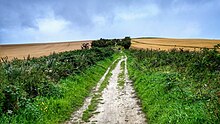
The Ridgeway is a ridgeway or ancient trackway described as Britain's oldest road. The section clearly identified as an ancient trackway extends from Wiltshire along the chalk ridge of the Berkshire Downs to the River Thames at the Goring Gap, part of the Icknield Way which ran, not always on the ridge, from Salisbury Plain to East Anglia. The route was adapted and extended as a National Trail, created in 1972. The Ridgeway National Trail follows the ancient Ridgeway from Overton Hill, near Avebury, to Streatley, then follows footpaths and parts of the ancient Icknield Way through the Chiltern Hills to Ivinghoe Beacon in Buckinghamshire. The National Trail is 87 miles (140 km) long.

<span class="mw-page-title-main">Icknield Way</span> Ancient trackway, one of the "Four Highways" of medieval England

The Icknield Way is an ancient trackway in southern and eastern England that runs from Norfolk to Wiltshire. It follows the chalk escarpment that includes the Berkshire Downs and Chiltern Hills.

<span class="mw-page-title-main">Long Mynd</span> Heath and moorland plateau in Shropshire, England

The Long Mynd is a heath and moorland plateau that forms part of the Shropshire Hills in Shropshire, England. The high ground, which is common land and designated as an Area of Outstanding Natural Beauty, lies between the Stiperstones range to the west and the Stretton Hills and Wenlock Edge to the east. Much of it is owned by the National Trust, and is managed by the Longmynd Commoners.

<span class="mw-page-title-main">Plank road</span> Road composed of wooden planks or puncheon logs

A plank road is a road composed of wooden planks or puncheon logs, as an efficient technology for traversing soft, marshy, or otherwise difficult ground. Plank roads were commonly found in the Canadian province of Ontario as well as the Northeast and Midwest of the United States in the first half of the 19th century. They were often built by turnpike companies.

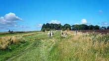
A ridgeway (road) is a road or path that follows a ridge, or the highest part of the landscape.

<span class="mw-page-title-main">Pilgrims' Way</span> Historic walking route in England

The Pilgrims' Way is the historical route supposedly taken by pilgrims from Winchester in Hampshire, England, to the shrine of Thomas Becket at Canterbury in Kent. This name, of comparatively recent coinage, is applied to a pre-existing ancient trackway dated by archaeological finds to 600–450 BC, but probably in existence since the Stone Age. The prehistoric route followed the "natural causeway" east to west on the southern slopes of the North Downs.

<span class="mw-page-title-main">History of Leicestershire</span>

This article is intended to give an overview of the history of Leicestershire.

<span class="mw-page-title-main">Historic roads and trails</span> Historical trail or road

Historic roads are paths or routes that have historical importance due to their use over a period of time. Examples exist from prehistoric times until the early 20th century. They include ancient trackways, long-lasting roads, important trade routes, and migration trails. Many historic routes, such as the Silk Road, the Amber Road, and the Royal Road of the Persian Empire, covered great distances and their impact on human settlements remain today.

<span class="mw-page-title-main">Herepath</span> Military road

A herepath or herewag is a military road in England, typically dating from the ninth century AD.

<span class="mw-page-title-main">Greenway (landscape)</span> Shared-use path or linear park with vegetation

A greenway is usually a shared-use path along a strip of undeveloped land, in an urban or rural area, set aside for recreational use or environmental protection. Greenways are frequently created out of disused railways, canal towpaths, utility company rights of way, or derelict industrial land. Greenways can also be linear parks, and can serve as wildlife corridors. The path's surface may be paved and often serves multiple users: walkers, runners, bicyclists, skaters and hikers. A characteristic of greenways, as defined by the European Greenways Association, is "ease of passage": that is that they have "either low or zero gradient", so that they can be used by all "types of users, including mobility impaired people".

<span class="mw-page-title-main">Greater Ridgeway</span> Long distance footpath crossing England

The Greater Ridgeway, also known as the Great Chalk Way, is a 362 miles long-distance footpath crossing England from Lyme Regis in Dorset to Hunstanton in Norfolk. It is a combined route which is made by joining four long-distance footpaths: the Wessex Ridgeway, The Ridgeway National Trail, the Icknield Way and the Peddars Way National Trail.

<span class="mw-page-title-main">Harrow Way</span> Ancient trackway

The Harrow Way is another name for the "Old Way", an ancient trackway in the south of England, dated by archaeological finds to 600–450 BC, but probably in existence since the Stone Age. The Old Way ran from Seaton in Devon to Dover, Kent. Later the eastern part of the Harrow Way become known as the Pilgrims' Way in the 19th century: the latter was a route invented by Albert Way of the Ordnance Survey, who imagined it to have been a pilgrimage route which ran from Winchester, Hampshire, via Farnham, Surrey, to Canterbury Kent. The western section of the Harrow Way ends in Farnham, the eastern in Dover.

<span class="mw-page-title-main">Hærvejen</span>

Hærvejen, sometimes referred to in English as the Ox Road, is the name given to an ancient trackway in Denmark and Schleswig-Holstein. The route runs from Viborg via Flensburg to Hamburg, the territory of which it entered at Ochsenzoll and where it connected with other roads. It has been known by several other names throughout history, most importantly "the Cattle Road" (Studevejen) and "the Oxen Road" or "Ox Road".

<span class="mw-page-title-main">Icknield Way Path</span> Long-distance footpath in East Anglia, England

The Icknield Way Path or Icknield Way Trail is a long distance footpath and riding route in East Anglia, England. The ancient Icknield Way itself is unique among long-distance trails because it can claim to be ‘the oldest road in Britain’. It consists of prehistoric pathways, ancient when the Romans came; the route is dotted with archaeological remains. It survives today in splendid tracks and green lanes along the ‘chalk spine’ of southern England.

<span class="mw-page-title-main">Sunken lane</span> Road or track that is lower than the land on either side

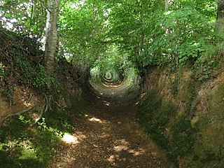
A sunken lane is a road or track that is significantly lower than the land on either side, not formed by the (recent) engineering of a road cutting but possibly of much greater age.

<span class="mw-page-title-main">Höllental (Black Forest)</span>

The Höllental in the Black Forest is a deep valley - in places like a gorge - in the state of Baden-Württemberg in Germany. The valley, which is about 9 km long, is located in the southern part of the Southern Black Forest Nature Park about 18 km southeast of Freiburg im Breisgau between Hinterzarten and Buchenbach-Himmelreich. The Rotbach stream runs through the valley. "Hölle" is the German word for "hell". In the narrow, dark valley, travellers almost felt like moving underground. The valley was the locale of the Battle of Emmendingen in 1796, part of the French Revolutionary Wars.

The Post Track is an ancient causeway in the valley of the River Brue on the Somerset Levels, England. It dates from around 3838 BCE, making it some 30 years older than the Sweet Track in the same area. Various sections have been scheduled as ancient monuments.

<span class="mw-page-title-main">Chiselbury</span> Iron Age hillfort in Wiltshire, England

Chiselbury is the site of an Iron Age univallate hillfort in Wiltshire, England. The hillfort is sub-circular in plan, and encloses an area of approximately 10.5 acres (460,000 sq ft). It is defined by an earthen rampart up to 3.6 metres (12 ft) in height and an external ditch, up to a maximum of 1.6 metres (5.2 ft) in depth. A gap in the south-eastern side of the rampart, and a corresponding causeway across the ditch, is thought to be the original entrance and is associated with a small D-shaped embanked enclosure, which is apparently visible on aerial photographs. Although the enclosure has subsequently been degraded by ploughing, it is still apparent as a series of low earthworks.

<span class="mw-page-title-main">Dorsetshire Gap</span>

The Dorsetshire Gap, also called the Dorset Gap, is an important, historic track junction - once the hub of central Dorset in southern England - and a well known beauty spot and magnet for ramblers. It is located on the northern slopes of Lyscombe Hill and not far from the village of Melcombe Bingham in the vicinity of grid reference ST743031. It is 13 km west-northwest of Bere Regis.

<span class="mw-page-title-main">Peak District Boundary Walk</span> Long distance footpath in England

The Peak District Boundary Walk is a circular 190-mile (310 km) walking trail, starting and finishing at Buxton and broadly following the boundary of the Peak District, Britain's first national park. The route was developed by the Friends of the Peak District and was launched on 17 June 2017.

References