Spaxton

Last updated

Spaxton
St. Margaret's church, Spaxton - geograph.org.uk - 145156.jpg
Court Farm, Spaxton - geograph.org.uk - 145152.jpg
Court Farm
Somerset UK location map.svg
Red pog.svg
Spaxton
Location within Somerset
Population1,012 (2012) [1]
OS grid reference ST225375
Unitary authority
Ceremonial county
Region
Country England
Sovereign state United Kingdom
Post town BRIDGWATER
Postcode district TA5
Dialling code 01278
Police Avon and Somerset
Fire Devon and Somerset
Ambulance South Western
UK Parliament
List of places
UK
England
Somerset
51°07′55″N3°06′32″W / 51.132°N 3.109°W / 51.132; -3.109

Spaxton is a small village and civil parish on the Quantocks in Somerset, South West England.

Contents

History

The name of Spaxton may originate from "Spakr", a Dane who settled in the area in about the 9th century. [2] An alternative derivation is that it means "councillor's enclosure", from the Old English spæcas and tun. It is recorded as "Spacheston" in the Domesday Book and was the property of Alfred of Spain. [3]

Spaxton was part of the hundred of Cannington. [4]

The National Gazetteer (1868) says:

"SPAXTON, a parish in the hundred of Cannington, county Somerset, 6 miles W. of Bridgwater, its post town, and 3 from Nether Stowey. The village is situated under the Quantock hills. The parish includes the hamlets of Courtway and Merridge. The soil consists of red clay, with a subsoil of stone. The living is a rectory* in the diocese of Bath and Wells, value £594. The church, dedicated to St. Margaret, has a square tower containing a clock and five bells. The register dates from 1558. The parochial charities produce about £106 per annum, of which £68 go to Cooke's school, almshouses, &c. There is a National school for both sexes, also a Sunday-school. The Baptists and Wesleyans have each a chapel. Lord Taunton is lord of the manor." [5]

The modern parish includes the ancient parishes of Aisholt and Charlynch. Aisholt is one of the Thankful Villages - those villages that suffered no fatalities during the Great War of 1914–1918. [6]

During the 19th century, Henry James Prince, former curate of Charlynch founded the notorious religious cult of the Agapemone at Four Forks. [7]

Governance

The parish council has responsibility for local issues, including setting an annual precept (local rate) to cover the council's operating costs and producing annual accounts for public scrutiny. The parish council evaluates local planning applications and works with the local police, district council officers, and neighbourhood watch groups on matters of crime, security, and traffic. The parish council's role also includes initiating projects for the maintenance and repair of parish facilities, as well as consulting with the district council on the maintenance, repair, and improvement of highways, drainage, footpaths, public transport, and street cleaning. Conservation matters (including trees and listed buildings) and environmental issues are also the responsibility of the council.

For local government purposes, since 1 April 2023, the village comes under the unitary authority of Somerset Council. Prior to this, it was part of the non-metropolitan district of Sedgemoor, which was formed on 1 April 1974 under the Local Government Act 1972, having previously been part of Bridgwater Rural District. [8]

It is also part of the Bridgwater and West Somerset county constituency represented in the House of Commons of the Parliament of the United Kingdom. It elects one Member of Parliament (MP) by the first past the post system of election.

Geography

Near the village is Hawkridge Reservoir which supplies water for Bridgwater, constructed between 1960 and 1962, [9] and the Ashford Reservoir which was constructed in 1932.

Landmarks and Notable Buildings

Religious sites

Related Research Articles

<span class="mw-page-title-main">Nether Stowey</span> Village in Somerset, England

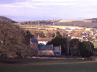
Nether Stowey is a large village in Somerset, South West England. It sits in the foothills of the Quantock Hills, just below Over Stowey. The parish of Nether Stowey covers approximately 4 km2, with a population of 1,373.

<span class="mw-page-title-main">Quantock Hills</span> Range of hills west of Bridgwater in Somerset, England

The Quantock Hills west of Bridgwater in Somerset, England, consist of heathland, oak woodlands, ancient parklands and agricultural land. They were England's first Area of Outstanding Natural Beauty, designated in 1956.

<span class="mw-page-title-main">West Bagborough</span> Human settlement in England

West Bagborough is a village and civil parish in Somerset, England, about 5 miles (8.0 km) north of Taunton. In 2011, the village had a population of 358.

<span class="mw-page-title-main">Bawdrip</span> Human settlement in England

Bawdrip is a village and civil parish in Somerset, England. The village is on the south side of the Polden Hills about 4 miles (6.4 km) north-east of Bridgwater. At the 2011 census the parish had a population of 506. The parish includes the hamlets of Bradney, Horsey and Knowle.

<span class="mw-page-title-main">Stogursey</span> Human settlement in England

Stogursey is the name of a small village and civil parish in the Quantock Hills in Somerset, England. It is situated 3 miles (4.8 km) from Nether Stowey, and 8 miles (12.9 km) west of Bridgwater. The village is situated near the Bristol Channel, which bounds the parish on the north.

<span class="mw-page-title-main">Otterhampton</span> Human settlement in England

Otterhampton is a village and civil parish in Somerset, England, between Bridgwater and the Steart Peninsula. The civil parish includes the larger village of Combwich and the small village of Steart.

<span class="mw-page-title-main">Holford</span> Village in West Somerset, England

Holford is a village and civil parish in West Somerset within the Quantock Hills Area of Outstanding Natural Beauty. It is located about 10 miles (16 km) west of Bridgwater and 6 miles (10 km) east of Williton, with a population of 392. The village is on the Quantock Greenway and Coleridge Way footpaths. The parish includes the village of Dodington.

<span class="mw-page-title-main">Crowcombe</span> Human settlement in England

Crowcombe is a village and civil parish under the Quantock Hills in Somerset, England, 5.5 miles (9 km) southeast of Watchet, and 8 miles (13 km) from Taunton. The village has a population of 489.

<span class="mw-page-title-main">Over Stowey</span> Village and civil parish in Somerset, England

Over Stowey is a small village and civil parish in Somerset, South West England. A large part of the forest and open heath of the Quantock Hills is within the parish and it includes the hamlets of Plainsfield, Aley, Adscombe, Friarn and Bincombe. It is adjacent to Nether Stowey, 8 miles (13 km) north-west of Bridgwater.

<span class="mw-page-title-main">Cannington, Somerset</span> Human settlement in England

Cannington is a village and civil parish 3 miles (5 km) northwest of Bridgwater in Somerset, England. It lies on the west bank of the River Parret, and contains the hamlet of Edstock.

<span class="mw-page-title-main">Chilton Trinity</span> Human settlement in England

Chilton Trinity is a village and civil parish on the River Parrett, 2 miles (3 km) north of Bridgwater in Somerset, England.

<span class="mw-page-title-main">Durleigh</span> Human settlement in England

Durleigh is a village and civil parish on the outskirts of Bridgwater in Somerset, England. According to the 2011 Census, it had a population of 548. Its nearest town is Bridgwater, which lies approximately 1.6 miles (2.6 km) north-east from the village.

<span class="mw-page-title-main">Enmore, Somerset</span> Human settlement in England

Enmore is a village and civil parish 2 miles (3 km) west of Bridgwater on the Quantock Hills in Somerset, England. The parish includes the hamlet of Bare Ash.

<span class="mw-page-title-main">St Mary's Church, Cannington</span> Church in Somerset, England

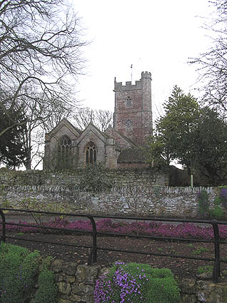
The Church of St Mary is the parish church of Cannington, Somerset, England. The parish is in the Church of England Diocese of Bath and Wells.

<span class="mw-page-title-main">St Mary's Church, Charlynch</span> Church in Somerset, England

The Church of St Mary at Charlynch in the parish of Spaxton, Somerset, England was an Anglican Parish Church, but has now been deconsecrated. It dates from the 11th century with a tower probably of 1867. It has been designated as a Grade I listed building.

<span class="mw-page-title-main">St Margaret's Church, Spaxton</span> Church in Somerset, England

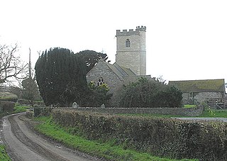
The Church of St Margaret in Spaxton, Somerset, England has some parts from the 12th and 13th centuries but is predominantly from the 15th century, and was restored in 1895. It has been designated as a Grade I listed building.

<span class="mw-page-title-main">Gothelney Hall</span> Building in Spaxton, England

Gothelney Hall, also known as Gothelney Manor Farmhouse, located in the parish of Spaxton, Somerset, England was built in the 15th century and has been designated as a Grade I listed building.

Bridgwater was a rural district in Somerset, England, from 1894 to 1974.

<span class="mw-page-title-main">Church of All Saints, Aisholt</span> Church in Somerset, England

All Saints Church in Aisholt, Somerset, England, is the Anglican parish church for the ancient parish of Aisholt, now part of the Quantock Villages Benefice in the Diocese of Bath and Wells, and lying in the Civil Parish of Spaxton. It is a Grade II* listed building.

<span class="mw-page-title-main">Church of St Mary the Virgin, Nether Stowey</span> Church in Somerset, England

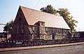
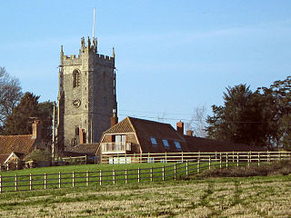
The Anglican Church of St Mary the Virgin in Nether Stowey in the English county of Somerset has a 15th-century tower, with the remainder of the church being rebuilt in 1851 by Richard Carver and Charles Edmund Giles. It is as a Grade II* listed building.

References

  1. "Statistics for Wards, LSOAs and Parishes — SUMMARY Profiles" (Excel). Somerset Intelligence. Retrieved 4 January 2014.
  2. "Spaxton". Quantock Online. Retrieved 31 October 2007.
  3. Robinson, Stephen (1992). Somerset Place Names. Wimborne, Dorset: Dovecote Press. ISBN   1-874336-03-2.
  4. "Cannington Hundred". British History Online. Retrieved 23 September 2011.
  5. "SPAXTON", in The National Gazetteer: A Topographical Dictionary of the British Islands, Vol. 3 (London: Virtue and Co., 1868), p. 507
  6. Historic England. "Church of All Saints, Aisholt (1178112)". National Heritage List for England . Retrieved 20 November 2008.
  7. "Spaxton". Quantock Online. Retrieved 4 December 2007.
  8. "Bridgwater RD". A vision of Britain Through Time. University of Portsmouth. Retrieved 4 January 2014.
  9. Waite, Vincent (1964). Portrait of the Quantocks. London: Robert Hale. ISBN   0-7091-1158-4.
  10. Historic England. "Gothelney Manor Farmhouse (1060185)". National Heritage List for England . Retrieved 14 May 2009.
  11. Pevsner, Nikolaus. The Buildings of England.
  12. Historic England. "Church of St Margaret (1060186)". National Heritage List for England . Retrieved 30 October 2007.
  13. R W Dunning, C R Elrington (Editors), A P Baggs, M C Siraut (1992). "Aisholt: Church". A History of the County of Somerset: Volume 6: Andersfield, Cannington, and North Petherton Hundreds (Bridgwater and neighbouring parishes). Institute of Historical Research. Retrieved 18 July 2013.{{cite web}}: |author= has generic name (help)CS1 maint: multiple names: authors list (link)
  14. Historic England. "Church of All Saints, Aisholt (1178112)". National Heritage List for England . Retrieved 18 July 2013.