| Goathurst | |
|---|---|
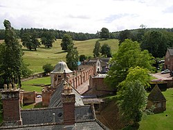 Halswell House | |
 Temple of Harmony | |
 Goathurst Location within Somerset | |
| Population | 193 (2011) [1] |
| OS grid reference | ST255345 |
| Unitary authority | |
| Ceremonial county | |
| Region | |
| Country | England |
| Sovereign state | United Kingdom |
| Post town | BRIDGWATER |
| Postcode district | TA5 |
| Dialling code | 01278 |
| Police | Avon and Somerset |
| Fire | Devon and Somerset |
| Ambulance | South Western |
| UK Parliament | |
Goathurst is a small village and civil parish in the English county of Somerset, around 3 miles from the town of Bridgwater. The parish includes the hamlets of Andersfield and Huntstile. The village is on the route of the Samaritans Way South West.
