Either side of it lie the villages of Chilton Polden and Catcott, and north of it is the small village of Burtle. There is a 12th-century church, but the nearest primary school is in the village of Catcott.
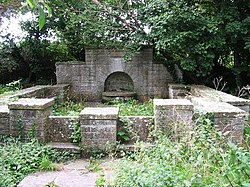
At the north end of the village is a Holy Well.[4]
History
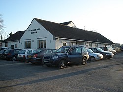
The Old Sunday School in Edington was founded in 1772 by Richard Field. The building now holds the Villages local history archives.
Archaeology
The 1888-1913 Ordnance Survey map of Edington shows the site of a Roman pottery kiln. Bronze Age palstaves have also been found at a site near Edington.[5]
The Domesday Book
Edington was located in the hundred of Whitley and the county of Somerset. In 1086, it had a recorded population of approximately 20.7 households. [6]
The parish council has responsibility for local issues, including setting an annual precept (local rate) to cover the council’s operating costs and producing annual accounts for public scrutiny. The parish council evaluates local planning applications and works with the local police, district council officers, and neighbourhood watch groups on matters of crime, security, and traffic. The parish council's role also includes initiating projects for the maintenance and repair of parish facilities, as well as consulting with the district council on the maintenance, repair, and improvement of highways, drainage, footpaths, public transport, and street cleaning. Conservation matters (including trees and listed buildings) and environmental issues are also the responsibility of the council.
The village falls within the 'West Polden' electoral ward. The ward stretches from Burtle in the north to Stawell in the south. The total ward population as at the 2011 census was 2,375.[9]
Dunning, Robert W. (2004). A history of the county of Somerset, Vol. 8, The Poldens and the Levels. Victoria history of the counties of England. University of London Institute of Historical Research. London: Boydell & Brewer. ISBN9781904356332. OCLC230765091.
This page is based on this Wikipedia article Text is available under the CC BY-SA 4.0 license; additional terms may apply. Images, videos and audio are available under their respective licenses.