Grade I listed buildings in Taunton Deane

Last updated

Taunton Deane is a local government district with borough status in the English county of Somerset. In the United Kingdom, the term listed building refers to a building or other structure officially designated as being of special architectural, historical or cultural significance; Grade I structures are those considered to be "buildings of exceptional interest". [1] Listing was begun by a provision in the Town and Country Planning Act 1947. Once listed, severe restrictions are imposed on the modifications allowed to a building's structure or its fittings. In England, the authority for listing under the Planning (Listed Buildings and Conservation Areas) Act 1990 [2] rests with Historic England, a non-departmental public body sponsored by the Department for Digital, Culture, Media and Sport; local authorities have a responsibility to regulate and enforce the planning regulations.

Contents

The district of Taunton Deane Area covers a population of approximately 100,000 [3] in an area of 462 square kilometres (178 sq mi). [4] It is centred on the town of Taunton, where around 60,000 of the population live [3] and the council are based, and includes surrounding suburbs and villages.

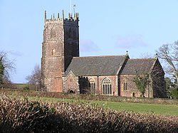
There are 38 Grade I listed buildings in Taunton Deane. The oldest buildings are churches built before the end of the 12th century, and the Castle Bow, which has been incorporated into the Castle Hotel in Taunton but was originally a gateway into Taunton Castle. The castle was created between 1107 and 1129, when William Giffard, the Chancellor of King Henry I, fortified the bishop's hall. It was his successor, Henry of Blois, who transformed the manor-house into a castle in 1138, during the Civil War that raged during the reign of his brother, King Stephen. Taunton is also the site of Gray's Almshouses, which dates from 1635, [5] and a building in Fore Street from the 16th century. [6] Most of the Grade I listed buildings in Taunton Deane are Norman or medieval era churches, many of which are included in the Somerset towers, a collection of distinctive, mostly spireless Gothic church towers. Many of the more recent structures in the list are manor houses such as Cothay Manor [7] and Greenham Barton [8] which were built in Stawley in the 15th century and 13th century respectively. Poundisford Park [9] and Cothelstone Manor [10] were both built in the 16th century and Hatch Court in 1755. [11] The most recent building included in the list is Hestercombe House, which was rebuilt in 1909. [12]

Map all coordinates using: OpenStreetMap

Buildings

See also

Notes

  1. The date given is the date used by Historic England as significant for the initial building or that of an important part in the structure's description.
  2. Sometimes known as OSGB36, the grid reference is based on the British national grid reference system used by the Ordnance Survey.
  3. The "List Entry Number" is a unique number assigned to each listed building and scheduled monument by Historic England.

Related Research Articles

<span class="mw-page-title-main">Quantock Hills</span> Range of hills west of Bridgwater in Somerset, England

The Quantock Hills west of Bridgwater in Somerset, England, consist of heathland, oak woodlands, ancient parklands and agricultural land. They were England's first Area of Outstanding Natural Beauty, designated in 1956.

<span class="mw-page-title-main">Bishop's Hull</span> Human settlement in England

Bishop's Hull is a village and civil parish in Somerset, England, in the western suburbs of Taunton. It includes the areas of Rumwell, Rumwell Park, Roughmoor and Longaller and is close to the River Tone. The parish, which includes the hamlet of Netherclay, has a population of 2,975 in total.

<span class="mw-page-title-main">Cheddon Fitzpaine</span> Human settlement in England

Cheddon Fitzpaine is a village and civil parish in Somerset, England, situated on the Quantock Hills 2 miles (3.2 km) north of Taunton. The village is situated near the Bristol and Exeter Railway, the Bridgwater and Taunton Canal, and the River Tone and has a population of 1,929.

<span class="mw-page-title-main">Chipstable</span> Human settlement in England

Chipstable is a village and civil parish in Somerset, England, situated beside Heydon Hill 10 miles (16.1 km) west of Taunton. The parish has a population of 309.

<span class="mw-page-title-main">Cothelstone</span> Human settlement in England

Cothelstone is a village and civil parish in Somerset, England, situated in the Quantock Hills six miles north of Taunton. The parish, which includes the hamlet of Toulton, has a population of 111.

<span class="mw-page-title-main">Kingston St Mary</span> Human settlement in England

Kingston St Mary is a village and parish in Somerset, England, situated at the southern end of the Quantock Hills 4 miles (6.4 km) north of Taunton. The village has a population of 921.

<span class="mw-page-title-main">Pitminster</span> Human settlement in England

Pitminster is a village and civil parish in Somerset, England, situated 4 miles (6.4 km) south of Taunton. The parish has a population of 956. The parish also includes the villages of Angersleigh, Blagdon Hill and Staplehay. The village of Blagdon is now officially known as Blagdon Hill to distinguish it from Blagdon in North Somerset. Hillside hamlets in the parish comprise Feltham and Woodram, those on the lower plain in the north are Sellicks Green which is contiguous with Blagdon Hill, Duddlestone and Poundisford.

<span class="mw-page-title-main">Stawley</span> Human settlement in England

Stawley is a village and civil parish in Somerset, England, situated 10 miles (16.1 km) west of Taunton. The parish has a population of 279 and includes the village of Kittisford and the hamlets of Appley, Greenham and Tracebridge.

<span class="mw-page-title-main">West Monkton</span> Human settlement in England

West Monkton is a village and civil parish in Somerset, England, situated 2 miles (3.2 km) north east of Taunton. The parish includes the hamlets of Monkton Heathfield, Bathpool, and Burlinch and the western parts of Coombe and Walford, and had a population of 2,787 at the 2011 census.

<span class="mw-page-title-main">Grade I listed buildings in Somerset</span> Buildings of exceptional interest in Somerset

The Grade I listed buildings in Somerset, England, demonstrate the history and diversity of its architecture. The ceremonial county of Somerset consists of a non-metropolitan county, administered by Somerset County Council, which is divided into five districts, and two unitary authorities. The districts of Somerset are West Somerset, South Somerset, Taunton Deane, Mendip and Sedgemoor. The two administratively independent unitary authorities, which were established on 1 April 1996 following the breakup of the county of Avon, are North Somerset and Bath and North East Somerset. These unitary authorities include areas that were once part of Somerset before the creation of Avon in 1974.

Mendip is a local government district in the English county of Somerset. The Mendip district covers a largely rural area of 285 square miles (738 km2) ranging from the Mendip Hills through on to the Somerset Levels. It has a population of approximately 11,000. The administrative centre of the district is Shepton Mallet.

Sedgemoor is a local government district in the English county of Somerset. In the United Kingdom, the term listed building refers to a building or other structure officially designated as being of special architectural, historical or cultural significance; Grade I structures are those considered to be "buildings of exceptional interest". Listing was begun by a provision in the Town and Country Planning Act 1947. Once listed, severe restrictions are imposed on the modifications allowed to a building's structure or its fittings. In England, the authority for listing under the Planning Act 1990 rests with Historic England, a non-departmental public body sponsored by the Department for Digital, Culture, Media and Sport; local authorities have a responsibility to regulate and enforce the planning regulations.

<span class="mw-page-title-main">Church of St Thomas of Canterbury, Cothelstone</span> Church in Somerset, England

The romanesque red sandstone Church of St Thomas of Canterbury in Cothelstone, Somerset, England dates from the 12th century and has been designated as a Grade I listed building.

<span class="mw-page-title-main">St Lawrence's Church, Lydeard St Lawrence</span> Church in Somerset, England

The Anglican Church of St Lawrence in Lydeard St Lawrence, Somerset, England dates from 1350 and has been designated as a Grade I listed building.

<span class="mw-page-title-main">Poundisford Park</span> Building in Pitminster, England

Poundisford Park north of Pitminster, Somerset, England is an English country house that typifies progressive housebuilding on the part of the West Country gentry in the mid-16th century. The main house was built for William Hill around 1550 and has been designated as a Grade I listed building.

<span class="mw-page-title-main">Cothelstone Manor</span> Building in Cothelstone, England

Cothelstone Manor in Cothelstone, Somerset, England was built in the mid-16th century, largely demolished by the parliamentary troops in 1646 and rebuilt by E.J. Esdaile in 1855–56.

<span class="mw-page-title-main">Greenham Barton</span> Grade I listed manor house in Somerset, England

Greenham Barton is a 13th-century manor house in the civil parish of Stawley, Somerset, England. Built in 1279, it has been designated as a Grade I listed building.

<span class="mw-page-title-main">Grade II* listed buildings in West Somerset</span>

West Somerset is a local government district in the county of Somerset which is in South West England. In the United Kingdom, the term listed building refers to a building or other structure officially designated as being of special architectural, historical or cultural significance; Grade II* structures are those considered to be "particularly significant buildings of more than local interest". Listing was begun by a provision in the Town and Country Planning Act 1947. Once listed, severe restrictions are imposed on the modifications allowed to a building's structure or its fittings. In England, the authority for listing under the Planning Act 1990 rests with Historic England, a non-departmental public body sponsored by the Department for Digital, Culture, Media and Sport; local authorities have a responsibility to regulate and enforce the planning regulations.

<span class="mw-page-title-main">Grade II* listed buildings in Taunton Deane</span>

Taunton Deane is a local government district with borough status in the English county of Somerset. In the United Kingdom, the term listed building refers to a building or other structure officially designated as being of special architectural, historical or cultural significance; Grade II* structures are those considered to be "particularly significant buildings of more than local interest". Listing was begun by a provision in the Town and Country Planning Act 1947. Once listed, severe restrictions are imposed on the modifications allowed to a building's structure or its fittings. In England, the authority for listing under the Planning Act 1990 rests with Historic England, a non-departmental public body sponsored by the Department for Digital, Culture, Media and Sport; local authorities have a responsibility to regulate and enforce the planning regulations.

<span class="mw-page-title-main">Scheduled monuments in Taunton Deane</span>

Taunton Deane was a local government district with borough status in Somerset, England. It merged with West Somerset to form Somerset West and Taunton on 1 April 2019. Its council was based in Taunton. The district was formed on 1 April 1974, under the Local Government Act 1972, by a merger of the Municipal Borough of Taunton, Wellington Urban District, Taunton Rural District, and Wellington Rural District. Taunton Deane was granted borough status in 1975, enabling the mayoralty of Taunton to be continued, when other districts did not have mayors. The district was given the name of an alternate form of the Taunton Deane Hundred.

References

  1. "Listed Buildings". Historic England. Retrieved 23 August 2017.
  2. "Planning (Listed Buildings and Conservation Areas) Act 1990 (c. 9)". Ministry of Justice. Archived from the original on 18 April 2010. Retrieved 17 December 2007.
  3. 1 2 "Demographics". Taunton Deane Borough Council. Archived from the original on 16 October 2007. Retrieved 25 April 2009.
  4. "Area: Taunton Deane (Local Authority): Key Figures for Physical Environment". Neighbourhood Statistics. Office for National Statistics. Retrieved 25 April 2009.
  5. 1 2 Historic England. "Gray's Almshouses (1232341)". National Heritage List for England . Retrieved 6 July 2015.
  6. 1 2 Historic England. "The cottage at the rear of No 15 Tudor Tavern (1060025)". National Heritage List for England . Retrieved 3 April 2015.
  7. 1 2 Historic England. "Cothay Manor (1176185)". National Heritage List for England . Retrieved 3 April 2015.
  8. 1 2 Historic England. "Greenham Barton (1176225)". National Heritage List for England . Retrieved 3 April 2015.
  9. 1 2 Historic England. "Poundisford Park (1060307)". National Heritage List for England . Retrieved 3 April 2015.
  10. 1 2 Historic England. "Gatehouse, Cothelstone Manor (1059192)". National Heritage List for England . Retrieved 3 April 2015.
  11. 1 2 Historic England. "Hatch Court (1060405)". National Heritage List for England . Retrieved 3 April 2015.
  12. 1 2 Historic England. "Garden walls, paving and steps on the south front of Hestercombe House (1060514)". National Heritage List for England . Retrieved 3 April 2015.
  13. Historic England. "Castle Bow (1060075)". National Heritage List for England . Retrieved 3 April 2015.
  14. Historic England. "Church of All Saints (1060318)". National Heritage List for England . Retrieved 3 April 2015.
  15. Historic England. "Church of All Saints (1060446)". National Heritage List for England . Retrieved 3 April 2015.
  16. Historic England. "Church of St Andrew & St Mary (1344587)". National Heritage List for England . Retrieved 6 July 2015.
  17. Historic England. "Church of St Augustine (1060422)". National Heritage List for England . Retrieved 3 April 2015.
  18. Historic England. "Church of St George (1177015)". National Heritage List for England . Retrieved 3 April 2015.
  19. Historic England. "Church of St Gregory (1060242)". National Heritage List for England . Retrieved 3 April 2015.
  20. Historic England. "Church of St James (1060602)". National Heritage List for England . Retrieved 3 April 2015.
  21. Historic England. "Church of St Lawrence (1176126)". National Heritage List for England . Retrieved 3 April 2015.
  22. Historic England. "Church of St John the Baptist (1060442)". National Heritage List for England . Retrieved 3 April 2015.
  23. Historic England. "Church of St John the Baptist (1176369)". National Heritage List for England . Retrieved 3 April 2015.
  24. Historic England. "Church of St Mary (1059248)". National Heritage List for England . Retrieved 3 April 2015.
  25. Historic England. "Church of St Mary (1176326)". National Heritage List for England . Retrieved 3 April 2015.
  26. Historic England. "Church of St Mary (1060290)". National Heritage List for England . Retrieved 3 April 2015.
  27. Historic England. "Church of St Mary Magdalene (1278073)". National Heritage List for England . Retrieved 3 April 2015.
  28. Historic England. "Church of St Michael (1060255)". National Heritage List for England . Retrieved 3 April 2015.
  29. Historic England. "Church of St Michael (1344496)". National Heritage List for England . Retrieved 3 April 2015.
  30. Historic England. "Church of St Michael (1060554)". National Heritage List for England . Retrieved 3 April 2015.
  31. Historic England. "Church of St Michael (1307667)". National Heritage List for England . Retrieved 3 April 2015.
  32. Historic England. "Church of St. Peter (1344574)". National Heritage List for England . Retrieved 3 April 2015.
  33. Historic England. "Church of St. Peter (1060274)". National Heritage List for England . Retrieved 3 April 2015.
  34. Historic England. "Church of St Peter & St Paul (1060267)". National Heritage List for England . Retrieved 6 July 2015.
  35. Historic England. "Church of St Peter & St Paul (1175444)". National Heritage List for England . Retrieved 6 July 2015.
  36. Historic England. "Church of St Peter & St Paul (1344525)". National Heritage List for England . Retrieved 6 July 2015.
  37. Historic England. "Church of the Holy Cross (1177251)". National Heritage List for England . Retrieved 3 April 2015.
  38. Historic England. "Church of St Thomas of Canterbury (1175656)". National Heritage List for England . Retrieved 3 April 2015.
  39. Historic England. "Orangery about 50 metres east of Hestercombe House (1175994)". National Heritage List for England . Retrieved 3 April 2015.
  40. Historic England. "Shell keep castle, part of the associated outer bailey, ninth century cemetery and a Civil War siegework at Taunton Castle (1013541)". National Heritage List for England . Retrieved 3 April 2015.