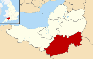
Bath and North East Somerset (commonly referred to as BANES or B&NES) is a unitary authority created on 1 April 1996, following the abolition of the County of Avon, which had existed since 1974. [1] Part of the ceremonial county of Somerset, Bath and North East Somerset occupies an area of 220 square miles (570 km2), two-thirds of which is green belt. [2] It stretches from the outskirts of Bristol, south into the Mendip Hills and east to the southern Cotswold Hills and Wiltshire border. [2] The city of Bath is the principal settlement in the district, but BANES also covers Keynsham, Midsomer Norton, Radstock and the Chew Valley. The area has a population of 170,000, about half of whom live in Bath, making it 12 times more densely populated than the rest of the area. [2]
In the United Kingdom, the term listed building refers to a building or other structure officially designated as being of special architectural, historical, or cultural significance; Grade I structures are those considered to be "buildings of exceptional interest". [3] Listing was begun by a provision in the Town and Country Planning Act 1947. Once listed, strict limitations are imposed on the modifications allowed to a building's structure or fittings. In England, the authority for listing under the Planning (Listed Buildings and Conservation Areas) Act 1990 [4] rests with Historic England, a non-departmental public body sponsored by the Department for Digital, Culture, Media and Sport; local authorities have a responsibility to regulate and enforce the planning regulations.
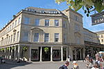
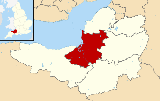
Bath and North East Somerset has 663 Grade I listed buildings, one of the highest concentrations in the country, [5] covered by about 120 Historic England listings. The oldest sites within Bath are the Roman Baths, for which the foundation piles and an irregular stone chamber lined with lead were built during the Roman occupation of Britain, [6] [7] although the current building is from the 18th century. [8] Bath Abbey was a Norman church built on earlier foundations, although the present building dates from the early 16th century and shows a late Perpendicular style with flying buttresses and crocketed pinnacles decorating a crenellated and pierced parapet. [9] [10] [11] The medieval era is represented by the remains of the city walls in Upper Borough Walls. [12]
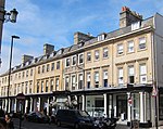
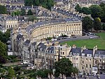
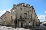
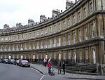
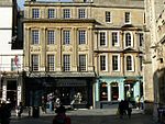
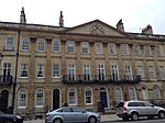
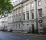
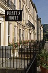
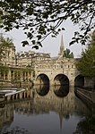
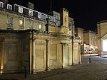
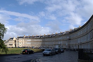
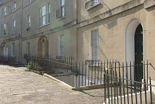
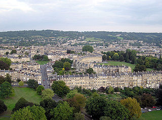
Most of Bath's Grade I listed buildings are made from the local golden-coloured Bath Stone, and date from the 18th and 19th centuries. Their dominant architectural style is Georgian, [13] which evolved from the Palladian revival style that became popular during the early 18th century. This led to the entire city's designation as a World Heritage Site. [14] Much of the development, and many of the buildings, were the vision of John Wood, the Elder. The Circus is seen as the pinnacle of Wood's work: it consists of three long, curved terraces that form a circular space or theatre intended for civic functions and games. The games give a clue to the design, the inspiration for which was the Colosseum in Rome. [13] The best known of Bath's terraces is the Royal Crescent, built between 1767 and 1774 and designed by Wood's son, John Wood, the Younger. [15] Around 1770 the neoclassical architect Robert Adam designed Pulteney Bridge, a three-arched bridge spanning the Avon. He used as his prototype an original, but unused, design by Palladio for the Rialto Bridge in Venice. [16] The heart of the Georgian city was the Pump Room, which together with its associated Lower Assembly Rooms was designed by Thomas Baldwin, a local builder responsible for many other buildings in the city, including the terraces in Argyle Street. [17] Great Pulteney Street, where Baldwin eventually lived, is another of his works: this wide boulevard, constructed c. 1789 and over 1,000 feet (305 m) long and 100 feet (30 m) wide, is lined on both sides by Georgian terraces. [18]
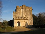
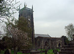
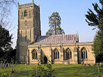
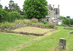
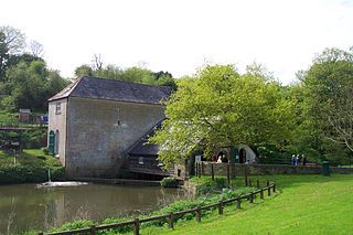
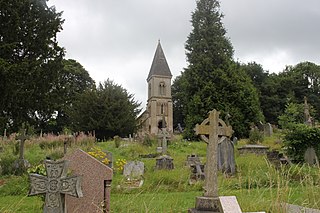
Outside the city of Bath, most of the Grade I listed buildings are Norman or medieval-era churches, many of which are included in the Somerset towers, a collection of distinctive, mostly spireless, Gothic church towers. Manor houses such as Claverton Manor, which now houses the American Museum in Britain, [19] and the 18th-century Newton Park, which has a landscape garden designed by Capability Brown, also appear in the list; [20] Newton Park now forms part of the Bath Spa University. Canal architecture includes Dundas Aqueduct and Claverton Pumping Station, both designed by John Rennie. The most recent building is the agricultural Eastwood Manor Farm Steading, completed in 1860. [21]
Bath is a city in the ceremonial county of Somerset in England, known for and named after its Roman-built baths. At the 2021 Census, the population was 94,092. Bath is in the valley of the River Avon, 97 miles (156 km) west of London and 11 miles (18 km) southeast of Bristol. The city became a UNESCO World Heritage Site in 1987, and was later added to the transnational World Heritage Site known as the "Great Spa Towns of Europe" in 2021. Bath is also the largest city and settlement in Somerset.
Lansdown Crescent is a well-known example of Georgian architecture in Bath, Somerset, England, designed by John Palmer and constructed by a variety of builders between 1789 and 1793. The buildings have a clear view over central Bath, being sited on Lansdown Hill near to, but higher than, other well-known Georgian buildings including the Royal Crescent, St James's Square, Bath and The Circus, Bath. It forms the central part of a string of curved terraces, including Lansdown Place East and West, and Somerset Place, which were the northernmost boundary of the development of Georgian Bath.
Bathwick is an area and electoral ward in the city of Bath, in the Bath and North East Somerset district, in the ceremonial county of Somerset, England, on the opposite bank of the River Avon to the historic city centre.
Claverton is a small village and civil parish about 2 miles (3 km) east of Bath at the southern end of the Cotswolds Area of Outstanding Natural Beauty, in Somerset, England. The parish has a population of 115.
John Pinch was an architect working mainly in the city of Bath, England. He was surveyor to the Pulteney and Darlington estate and responsible for many of the later Georgian buildings in Bath, especially in Bathwick.
Great Pulteney Street is a grand thoroughfare that connects Bathwick on the east of the River Avon with the City of Bath, England via the Robert Adam designed Pulteney Bridge. Viewed from the city side of the bridge the road leads directly to the Holburne Museum of Art that was originally the Sydney Hotel where tea rooms, card rooms, a concert room and a ballroom were installed for the amusement of Bath's many visitors.
There are 212 Grade II* listed buildings in Bristol, England.
The Grade I listed buildings in Somerset, England, demonstrate the history and diversity of its architecture. The ceremonial county of Somerset consists of a non-metropolitan county, administered by Somerset County Council, which is divided into five districts, and two unitary authorities. The districts of Somerset are West Somerset, South Somerset, Taunton Deane, Mendip and Sedgemoor. The two administratively independent unitary authorities, which were established on 1 April 1996 following the breakup of the county of Avon, are North Somerset and Bath and North East Somerset. These unitary authorities include areas that were once part of Somerset before the creation of Avon in 1974.
Widcombe is a district of Bath, England, immediately south-east of the city centre, across the River Avon.
Sedgemoor is a local government district in the English county of Somerset. In the United Kingdom, the term listed building refers to a building or other structure officially designated as being of special architectural, historical or cultural significance; Grade I structures are those considered to be "buildings of exceptional interest". Listing was begun by a provision in the Town and Country Planning Act 1947. Once listed, severe restrictions are imposed on the modifications allowed to a building's structure or its fittings. In England, the authority for listing under the Planning Act 1990 rests with Historic England, a non-departmental public body sponsored by the Department for Digital, Culture, Media and Sport; local authorities have a responsibility to regulate and enforce the planning regulations.
South Somerset is a local government district in the English county of Somerset. The South Somerset district occupies an area of 370 square miles (958 km2), stretching from its borders with Devon and Dorset to the edge of the Somerset Levels. The district has a population of about 158,000, and has Yeovil as its administrative centre.
Gay Street in Bath, Somerset, England, links Queen Square to The Circus. It was designed by John Wood, the Elder in 1735 and completed by his son John Wood, the Younger. The land was leased to the elder Wood by Robert Gay, MP for Bath, and the street is named after him. Much of the road has been designated as Grade I listed buildings.
Camden Crescent in Bath, Somerset, England, was built by John Eveleigh in 1788; it was originally known as Upper Camden Place. Numbers 6 to 21 have been designated as a Grade I listed buildings. The other houses are Grade II listed.
South Parade in Bath, Somerset, England, is a historic terrace built around 1743 by John Wood, the Elder. All of the houses have been designated as Grade I listed buildings.
The buildings and architecture of Bath, a city in Somerset in the south west of England, reveal significant examples of the architecture of England, from the Roman Baths, to the present day. The city became a World Heritage Site in 1987, largely because of its architectural history and the way in which the city landscape draws together public and private buildings and spaces. The many examples of Palladian architecture are purposefully integrated with the urban spaces to provide "picturesque aestheticism". In 2021, the city was added to a second World Heritage Site, a group of historic spa towns across Europe known as the "Great Spas of Europe". Bath is the only entire city in Britain to achieve World Heritage status, and is a popular tourist destination.
The Anglican Bath Abbey Cemetery, officially dedicated as the Cemetery of St Peter and St Paul, was laid out by noted cemetery designer and landscape architect John Claudius Loudon (1783–1843) between 1843 and 1844 on a picturesque hillside site overlooking Bath, Somerset, England.
Bath and North East Somerset is a unitary authority created on 1 April 1996, following the abolition of the County of Avon, which had existed since 1974. Part of the ceremonial county of Somerset, Bath and North East Somerset occupies an area of 220 square miles (570 km2), two-thirds of which is green belt. It stretches from the outskirts of Bristol, south into the Mendip Hills and east to the southern Cotswold Hills and Wiltshire border. The city of Bath is the principal settlement in the district, but BANES also covers Keynsham, Midsomer Norton, Radstock and the Chew Valley. The area has a population of 170,000, about half of whom live in Bath, making it 12 times more densely populated than the rest of the area.
Sedgemoor is a local government district in the English county of Somerset. In the United Kingdom, the term listed building refers to a building or other structure officially designated as being of special architectural, historical or cultural significance; Grade II* structures are those considered to be "particularly significant buildings of more than local interest". Listing was begun by a provision in the Town and Country Planning Act 1947. Once listed, severe restrictions are imposed on the modifications allowed to a building's structure or its fittings. In England, the authority for listing under the Planning Act 1990 rests with Historic England, a non-departmental public body sponsored by the Department for Digital, Culture, Media and Sport; local authorities have a responsibility to regulate and enforce the planning regulations.
Taunton Deane is a local government district with borough status in the English county of Somerset. In the United Kingdom, the term listed building refers to a building or other structure officially designated as being of special architectural, historical or cultural significance; Grade II* structures are those considered to be "particularly significant buildings of more than local interest". Listing was begun by a provision in the Town and Country Planning Act 1947. Once listed, severe restrictions are imposed on the modifications allowed to a building's structure or its fittings. In England, the authority for listing under the Planning Act 1990 rests with Historic England, a non-departmental public body sponsored by the Department for Digital, Culture, Media and Sport; local authorities have a responsibility to regulate and enforce the planning regulations.
Lytham is a conurbation in the Borough of Fylde, Lancashire, England that includes the town of Lytham and the districts of Ansdell and Fairhaven. It contains 91 buildings that are recorded in the National Heritage List for England as designated listed buildings. Of these, one is listed at Grade I, the highest of the three grades, four are at Grade II*, the middle grade, and the others are at Grade II, the lowest grade.
Media related to Grade I listed buildings in Bath and North East Somerset District at Wikimedia Commons