Bath and North East Somerset (B&NES) is a unitary authority district in Somerset, South West England. Bath and North East Somerset Council was created on 1 April 1996 following the abolition of the county of Avon. It is part of the ceremonial county of Somerset.
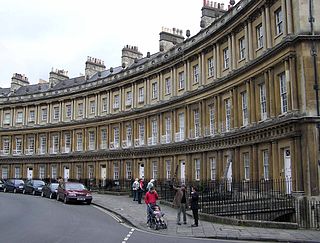
The Circus is a historic ring of large townhouses in the city of Bath, Somerset, England, forming a circle with three entrances. Designed by architect John Wood, the Elder, it was built between 1754 and 1768, and is regarded as a pre-eminent example of Georgian architecture. "Circus" means a ring, oval or circle in Latin. The construction has been designated as a Grade I listed building.
Chew Stoke is a small village and civil parish in the affluent Chew Valley, in Somerset, England, about 8 miles (13 km) south of Bristol and 10 miles north of Wells. It is at the northern edge of the Mendip Hills, a region designated by the United Kingdom as an Area of Outstanding Natural Beauty, and is within the Bristol and Bath green belt. The parish includes the hamlet of Breach Hill, which is approximately 2 miles (3.2 km) southwest of Chew Stoke itself.

Somerset Place is a Georgian Grade I listed crescent in Bath, England. The facades were designed by the architect John Eveleigh, who went bankrupt during the creation of the building, which started in 1790 but was not completed until the 1820s.

Chewton Keynsham is a hamlet on the River Chew in the Chew Valley, Somerset, England. It is 7 miles from Bristol, 7 miles from Bath, and 2 miles (3.2 km) south of the centre of the town of Keynsham.

The Museum of Bath Architecture in Bath, Somerset, England, occupies the Countess of Huntingdon's Chapel, where it provides exhibits that explain the building of the Georgian era city during the 18th century.

The Grade I listed buildings in Somerset, England, demonstrate the history and diversity of its architecture. The ceremonial county of Somerset consists of a non-metropolitan county, administered by Somerset County Council, which is divided into five districts, and two unitary authorities. The districts of Somerset are West Somerset, South Somerset, Taunton Deane, Mendip and Sedgemoor. The two administratively independent unitary authorities, which were established on 1 April 1996 following the breakup of the county of Avon, are North Somerset and Bath and North East Somerset. These unitary authorities include areas that were once part of Somerset before the creation of Avon in 1974.
Widcombe is a district of Bath, England, immediately south-east of the city centre, across the River Avon.

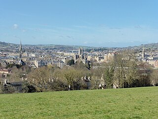
Bath and North East Somerset is a unitary authority created on 1 April 1996, following the abolition of the County of Avon, which had existed since 1974. Part of the ceremonial county of Somerset, Bath and North East Somerset occupies an area of 220 square miles (570 km2), two-thirds of which is green belt. It stretches from the outskirts of Bristol, south into the Mendip Hills and east to the southern Cotswold Hills and Wiltshire border. The city of Bath is the principal settlement in the district, but BANES also covers Keynsham, Midsomer Norton, Radstock and the Chew Valley. The area has a population of 170,000, about half of whom live in Bath, making it 12 times more densely populated than the rest of the area.

Duke Street in Bath, Somerset, England was built in 1748 by John Wood, the Elder. Several of the buildings have been designated as Grade I listed buildings. The street, which overlooks the River Avon, is pedestrianised with no vehicles permitted to enter.

North Parade in Bath, Somerset, England is a historic terrace built around 1741 by John Wood, the Elder. Several of the houses have been designated as Grade I listed buildings.

South Parade in Bath, Somerset, England, is a historic terrace built around 1743 by John Wood, the Elder. All of the houses have been designated as Grade I listed buildings.

St James's Square in Bath, Somerset, England consists of 45 Grade I listed buildings. It was built in 1793 by John Palmer.

Portland Place in Bath, Somerset, England was built around 1786 and many of the houses have been designated as listed buildings.

Cheap Street in Bath, Somerset, England is adjacent to Bath Abbey and contains several listed buildings.

Grosvenor Place in Bath, Somerset, England was built around 1790 by John Eveleigh. It lies on the south side of the A4 London Road and many of the houses are listed buildings.

Johnstone Street in the Bathwick area of Bath, Somerset, England was designed in 1788 by Thomas Baldwin, with some of the buildings being completed around 1805-1810 by John Pinch the elder.

Kingsmead Square in Bath, Somerset, England, was laid out by John Strahan in the 1730s. Many of the houses are listed buildings.

Sion Hill Place in the Lansdown area of Bath, Somerset, England was designed by John Pinch the elder and built between 1818 and 1820. Suspension bridge builder and brewer James Dredge, Sr. lived here in the mid 19th century.

Upper Borough Walls is a historic street in Bath, Somerset, England. Many of the structures are listed buildings.

