Pulteney Bridge

Last updated

Pulteney Bridge
Puente Pulteney, Bath, Inglaterra, 2014-08-12, DD 51.JPG
Pulteney Bridge in 2014
Coordinates 51°22′59″N2°21′28″W / 51.38306°N 2.35778°W / 51.38306; -2.35778
CarriesBuses, taxis, cyclists, pedestrians
Crosses River Avon
Locale Bath
Maintained by Bath and North East Somerset
Characteristics
DesignArch bridge
Material Bath stone
Total length45 metres (148 ft)
Width18 metres (58 ft)
No. of spans3
Piers in water2
History
Designer Robert Adam
Constructed byReed and Lowther (bridge)
Singers and Lankeshere (shops)
Construction start1769
Construction end1774
Location
Pulteney Bridge

Pulteney Bridge is a bridge over the River Avon in Bath, England. It was completed by 1774, and connected the city with the land of the Pulteney family which the family wished to develop. Designed by Robert Adam in a Palladian style, it is highly unusual in that it has shops built across its full span on both sides. It has been designated as a Grade I listed building. [1]

Contents

Within 20 years of its construction, alterations were made that expanded the shops and changed the façades. By the end of the 18th century, it had been damaged by floods, but was rebuilt to a similar design. Over the next century alterations to the shops included cantilevered extensions on the bridge's north face. In the 20th century, several schemes were carried out to preserve the bridge and partially return it to its original appearance, enhancing its appeal as a tourist attraction.
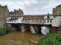
The bridge is now 45 metres (148 ft) long and 18 metres (58 ft) wide. Although there have been plans to pedestrianise the bridge, it is still used by buses and taxis. The much photographed bridge and weir below are close to the centre of the city, a World Heritage Site, renowned for its Georgian architecture.

Background

The bridge is named after Frances Pulteney, wife of William Johnstone. He was a wealthy Scottish lawyer and Member of Parliament (MP). Frances was the third daughter of MP and government official Daniel Pulteney (1684–1731) and first cousin once removed of William Pulteney, 1st Earl of Bath. She inherited the Earl's substantial fortune and estates close to Bath in Somerset after his death in 1764 and that of his younger brother and heir in 1767, and the Johnstones changed their surname to Pulteney. The rural Bathwick estate, which Frances and William inherited in 1767, was across the river from the city and could only be reached by ferry. William made plans to create a new town, which would become a suburb to the historic city of Bath, but first he needed a better river crossing. [2] The work of the Pulteneys is memorialised by Great Pulteney Street in Bathwick, [3] and Henrietta Street and Laura Place, named after their daughter Henrietta Laura Johnstone. [4] [5]

Design and construction

Pulteney Bridge by Thomas Malton in 1785 Malton Pulteney Bridge 1785.JPG
Pulteney Bridge by Thomas Malton in 1785

Pultney Bridge was designed by Robert Adam, [2] [6] whose original drawings are preserved in the Sir John Soane's Museum in London. [1] [7] It is one of only four bridges in the world to have shops across its full span on both sides, the others being in Italy (in Florence and Venice) and in Erfurt, Germany. [8]

Initial plans for the bridge were drawn up by Thomas Paty, who estimated it would cost £4,569 to build, but that did not include the shops. [9] A second estimate of £2,389 was obtained from local builders John Lowther and Richard Reed; it included two shops at each end of the bridge, but work did not begin before winter weather made construction of the pillars impossible. In 1770 the brothers Robert and James Adam, who were working on designs for the new town at Bathwick, adapted Paty's original design. [9] Robert Adam envisaged an elegant structure lined with shops, similar to the Ponte Vecchio and the Ponte di Rialto he would likely have seen when he visited Florence and Venice. Adam's design more closely followed Andrea Palladio's rejected design for the Rialto. [2] The revised bridge was 15 metres (50 ft) wide, rather than the 9.1 metres (30 ft) width envisaged by Paty, which overcame the objections of the local council about the bridge being too narrow. [9]

Construction started in 1769 and was completed by 1774 at a cost of £11,000. [10] [11] The builders for the lower part of the bridge were local masons Reed and Lowther; the shops were constructed by Singers and Lankeshere. [9]

Development

Pulteney Bridge stood for less than 20 years in the form that Adam created. In 1792 alterations were made during which the bridge was widened to 18 metres (58 ft) and the shops enlarged, converting the original sixteen shops into six larger ones. [9] Floods in 1799 and 1800 wrecked the north side of the bridge, which had been constructed with inadequate support. A temporary bridge was erected, and repairs were completed in 1804. [11] Thomas Telford suggested replacing the bridge with a single span cast iron bridge. However it was rebuilt by John Pinch senior, surveyor to the Pulteney estate, in a less ambitious version of Adam's design. [10] Nineteenth-century shopkeepers changed the structure and appearance of their premises by changing windows, or expanding them by adding cantilevers over the river. Some painted advertisements on the outside of their shops, affecting the view from the river and Grand Parade. [9] The western end pavilion on the south side was demolished in 1903 for road widening and its replacement was not an exact match. [9]

Pulteney Bridge in 2007 Pulteney Bridge, Bath 2.jpg
Pulteney Bridge in 2007

In 1936 the bridge was designated an ancient monument. [12] The city council bought several of the shops and made plans for the restoration of the original façade, [9] which was completed in time for the Festival of Britain in 1951. [7] The status of the bridge as an ancient monument was replaced in 1955 with its designation as a Grade I listed building. [12] Further work was carried out in the 1960s to repair the underside soffits of all three arches. [13] More restoration of the southern street facade was needed in 1975. [2]

In 2009 Bath and North East Somerset council put forward a proposal to close the bridge to motor traffic and convert it to a pedestrianised zone, [14] [15] but the plan was abandoned in September 2011. [16] It however remains a large source of income for the council, due to it being the most fined bus lane in the city. [17]

Architecture

Pulteney Bridge in 1779 by Thomas Malton Malton-pulteney-bridge-in-1779.jpg
Pulteney Bridge in 1779 by Thomas Malton

The bridge features a narrow street flanked by two full length rows of shops designed in the Palladian style c. 1770. All sit above three segmental arches of equal span. [18] The shops on the north side have cantilevered rear extensions. [19] [20] Consequently, the northern external façade of the bridge is asymmetrical, much altered and of no architectural merit, [9] whereas the southern external side clearly shows the hand of Robert Adam.

Built of limestone, in classic Palladian style, the southern façade takes the form of a temple-like central bay with symmetrical wings connecting to two flanking, terminating pavilions. The central bay is given eminence by a broken pediment supported by austere Doric pilasters. It in turn is flanked by two small bays, each with a small pointed pediment supported by shallow pilasters, which further emphasise and complement the central broken pediment sitting above a large Palladian window  – the focal point of the building. On this southern side the structure comprises a principal floor at street level, with a low mezzanine separated by stone banding above. Beneath the principal floor is a sub-floor constructed in the masonry between the spans of the bridge, its presence indicated by ocular windows placed symmetrically beneath the span of each arch. This ocular motif, on a reduced scale, is repeated symmetrically at mezzanine level beneath the central broken pediment. The two terminating pavilions, in reality slight projections, have shallow saucer domes concealed behind their pointed pediments. The roof is pitched and of Welsh slate.

The western mid-stream pier was rebuilt in 1804. [10] Further alteration took place in 1895, when the western pavilion was moved for the construction of the Grand Parade. The appearance changed yet again when the current weir, the scene of Javert's suicide in the film version of Les Misérables , [21] [22] was constructed between 1968 and 1972 as part of a flood-prevention scheme. [10] [23] Further restoration was undertaken in 1975.

See also

Related Research Articles

<span class="mw-page-title-main">Bath, Somerset</span> City in Somerset, England

Bath is a city in the Bath and North East Somerset unitary area in the ceremonial county of Somerset, England, known for and named after its Roman-built baths. At the 2021 Census, the population was 101,557. Bath is in the valley of the River Avon, 97 miles (156 km) west of London and 11 miles (18 km) southeast of Bristol. The city became a UNESCO World Heritage Site in 1987, and was later added to the transnational World Heritage Site known as the "Great Spa Towns of Europe" in 2021. Bath is also the largest city and settlement in Somerset.

<span class="mw-page-title-main">River Avon, Bristol</span> River in the south west of England

The River Avon is a river in the southwest of England. To distinguish it from a number of other rivers of the same name, it is often called the Bristol Avon. The name 'Avon' is a cognate of the Welsh word afon, meaning 'river'.

<span class="mw-page-title-main">Prior Park</span> Grade I listed Palladian building in south west England

Prior Park is a Neo-Palladian house that was designed by John Wood, the Elder, and built in the 1730s and 1740s for Ralph Allen on a hill overlooking Bath, Somerset, England. It has been designated as a Grade I listed building.

<span class="mw-page-title-main">Cleveland Bridge</span> Bridge in Bath, England

Cleveland Bridge over the River Avon is a grade II* listed building located in the World Heritage Site of Bath, England. It is notable for the unusual lodges that adorn each corner in a style that could be likened to miniature Greek temples.

<span class="mw-page-title-main">Bathwick</span> Electoral ward in Bath, England

Bathwick is an electoral ward in the City of Bath, England, on the opposite bank of the River Avon to the historic city centre.

Henry Edmund Goodridge was an English architect based in Bath. He worked from the early 1820s until the 1850s, using Classical, Italianate and Gothic styles.

<span class="mw-page-title-main">Sir William Pulteney, 5th Baronet</span> Scottish lawyer, politician and landowner (1729–1805)

Sir William Pulteney, 5th Baronet was a Scottish lawyer, Whig politician and landowner who sat in the British House of Commons between 1768 and 1805. One of the wealthiest Britons during his lifetime, he invested in the construction of several prominent buildings in Britain, including the Pulteney Bridge and other properties in Bath, Somerset, several beachfront residences in Weymouth, Dorset and roads in Scotland. Pulteney was also a patron of architect Robert Adam and civil engineer Thomas Telford. He also owned slave plantations in British America.

John Pinch was an architect working mainly in the city of Bath, England. He was surveyor to the Pulteney and Darlington estate and responsible for many of the later Georgian buildings in Bath, especially in Bathwick.

<span class="mw-page-title-main">Great Pulteney Street</span> Street in Bath, England

Great Pulteney Street is a grand thoroughfare that connects Bathwick on the east of the River Avon with the City of Bath, England via the Robert Adam designed Pulteney Bridge. Viewed from the city side of the bridge the road leads directly to the Holburne Museum of Art that was originally the Sydney Hotel where tea rooms, card rooms, a concert room and a ballroom were installed for the amusement of Bath's many visitors.

Thomas Baldwin was an English architect in the city of Bath, who was responsible for designing some of Bath's principal Georgian buildings.

<span class="mw-page-title-main">St Mary the Virgin's Church, Bathwick</span> Church in United Kingdom

The Church of St Mary the Virgin is located on Darlington Street in the Bathwick area of Bath, Somerset, England. The church is Anglican and located near Pinch's Sydney Place (1808) and Bath's famed Sydney Pleasure Gardens. The church was constructed by the Pulteney family, who used it to replace the medieval parish church of St Mary's, Bathwick, known even in Georgian times as Bathwick Old Church. The churchyard is now part of Smallcombe Cemetery.

<span class="mw-page-title-main">Grade I listed buildings in Somerset</span> Buildings of exceptional interest in Somerset

The Grade I listed buildings in Somerset, England, demonstrate the history and diversity of its architecture. The ceremonial county of Somerset consists of a non-metropolitan county, administered by Somerset County Council, which is divided into five districts, and two unitary authorities. The districts of Somerset are West Somerset, South Somerset, Taunton Deane, Mendip and Sedgemoor. The two administratively independent unitary authorities, which were established on 1 April 1996 following the breakup of the county of Avon, are North Somerset and Bath and North East Somerset. These unitary authorities include areas that were once part of Somerset before the creation of Avon in 1974.

<span class="mw-page-title-main">Grade I listed buildings in Bath and North East Somerset</span>

Bath and North East Somerset is a unitary authority created on 1 April 1996, following the abolition of the County of Avon, which had existed since 1974. Part of the ceremonial county of Somerset, Bath and North East Somerset occupies an area of 220 square miles (570 km2), two-thirds of which is green belt. It stretches from the outskirts of Bristol, south into the Mendip Hills and east to the southern Cotswold Hills and Wiltshire border. The city of Bath is the principal settlement in the district, but BANES also covers Keynsham, Midsomer Norton, Radstock and the Chew Valley. The area has a population of 170,000, about half of whom live in Bath, making it 12 times more densely populated than the rest of the area.

<span class="mw-page-title-main">North Parade, Bath</span> Street in Bath and North East Somerset, United Kingdom

North Parade in Bath, Somerset, England is a historic terrace built around 1741 by John Wood, the Elder. Several of the houses have been designated as Grade I listed buildings.

<span class="mw-page-title-main">Cleveland Pools</span> Oldest public outdoor swimming pool in England

Cleveland Pools located in Hampton Row, Bath, Somerset, England is a semi-circular lido built to designs by John Pinch the Elder in 1815. It is believed to be the oldest public outdoor swimming pool in the UK. It is a Grade II* listed building.

<span class="mw-page-title-main">Buildings and architecture of Bath</span> Permanent structures including significant examples of English architecture from the Roman Baths

The buildings and architecture of Bath, a city in Somerset in the south west of England, reveal significant examples of the architecture of England, from the Roman Baths, to the present day. The city became a World Heritage Site in 1987, largely because of its architectural history and the way in which the city landscape draws together public and private buildings and spaces. The many examples of Palladian architecture are purposefully integrated with the urban spaces to provide "picturesque aestheticism". In 2021, the city was added to a second World Heritage Site, a group of historic spa towns across Europe known as the "Great Spas of Europe". Bath is the only entire city in Britain to achieve World Heritage status, and is a popular tourist destination.

<span class="mw-page-title-main">Bath Abbey Cemetery</span> Cemetery in Bath and North East Somerset, UK

The Anglican Bath Abbey Cemetery, officially dedicated as the Cemetery of St Peter and St Paul, was laid out by noted cemetery designer and landscape architect John Claudius Loudon (1783–1843) between 1843 and 1844 on a picturesque hillside site overlooking Bath, Somerset, England.

<span class="mw-page-title-main">Sydney Gardens</span> Public open space in Bath, England

Sydney Gardens is a public open space at the end of Great Pulteney Street in Bath, Somerset, England. The gardens are the only remaining eighteenth-century pleasure gardens in the country. They are Grade II listed on the Register of Historic Parks and Gardens of special historic interest in England.

<span class="mw-page-title-main">Argyle Street, Bath</span> Historic site in Somerset, England

Argyle Street is a historic street in the centre of Bath, England located between Pulteney Bridge and Laura Place.

<span class="mw-page-title-main">Sydney Gardens Tunnels</span> Canal tunnels in Britain

The Sydney Gardens Tunnels are two canal tunnels on the Kennet and Avon Canal in Bath, UK. The No. 1 Tunnel brings the canal into Sydney Gardens from the south and the No. 2 Tunnel exits the gardens to the north. Both tunnels are Grade II* listed, and are two of three on the waterway—the third being the Bruce Tunnel in Wiltshire.

References

Notes

  1. 1 2 "Pulteney Bridge". Images of England. English Heritage. Archived from the original on 15 October 2007. Retrieved 27 September 2008.
  2. 1 2 3 4 "Pulteney Bridge". Bath Past. Jean Manco. Retrieved 15 August 2009.
  3. "Great Poulteney Street, Bath". British Library. Retrieved 23 March 2013.
  4. "Laura Place". Bath Heritage. Retrieved 23 March 2013.
  5. "1996.5: Henrietta Laura Pulteney (1766–1808)". Holburne Museum. Archived from the original on 15 August 2011. Retrieved 25 April 2013.
  6. "Pulteney Bridge". Structurae. Retrieved 3 March 2013.
  7. 1 2 "Pulteney Bridge, Bath". Transport Heritage. Archived from the original on 10 March 2014. Retrieved 3 March 2013.
  8. "Explore the World's 4 Remaining Inhabited Bridges". Anew Traveller. 16 January 2018. Retrieved 26 October 2021.
  9. 1 2 3 4 5 6 7 8 9 Manco, Jean (1995). "Pulteney Bridge". Architectural History. 38 (38): 129–145. doi:10.2307/1568625. JSTOR   1568625. S2CID   246044781.
  10. 1 2 3 4 Historic England. "Pulteney Bridge (1394514)". National Heritage List for England . Retrieved 3 March 2013.
  11. 1 2 Buchanan, Angus (1990). Bath History Volume III: The Bridges of Bath (PDF). pp. 6–7.
  12. 1 2 "Details of location and proposal: Café Au Lait Ltd, 7 Pulteney Bridge, City Centre, Bath, BA2 4AX" (PDF). Bath and North East Somerset Council. Archived from the original (PDF) on 4 March 2016. Retrieved 3 March 2013.
  13. "History of Pulteney Bridge". Pulteney Cruisers. Archived from the original on 5 September 2008. Retrieved 3 March 2013.
  14. "Pulteney Bridge pedestrianisation plans". Bath Chronicle. Retrieved 25 April 2013.
  15. "Famous Pulteney Bridge in Bath under threat after cracks appear". SWNS. Archived from the original on 3 March 2016. Retrieved 25 April 2013.
  16. "Historic Pulteney Bridge traffic ban dropped". Bath Chronicle. Retrieved 24 March 2013.
  17. "The Bath bus lane where you are most likely to be fined if caught driving there". Somerset Live. 6 September 2018. Retrieved 6 September 2018.
  18. Skempton (2002), p. 8.
  19. Historic England. "Shops Nos 9 to 17 (1394516)". National Heritage List for England . Retrieved 3 March 2013.
  20. Historic England. "Shops Nos 1 to 8 (1394515)". National Heritage List for England . Retrieved 3 March 2013.
  21. "Hollywood comes to Bath as Les Miserables filmed at Pulteney Weir". Bath Chronicle. 23 October 2012. Retrieved 13 March 2013.
  22. "Production notes" (PDF). Les Miserables. p. 40. Archived from the original on 24 March 2013. Retrieved 14 March 2013.{{cite web}}: CS1 maint: bot: original URL status unknown (link)
  23. Forsyth (2003), p. 125.

Bibliography