Great Pulteney Street

Last updated

A view down Great Pulteney Street from Laura Place fountain GreatPulteneyStreet.jpg
A view down Great Pulteney Street from Laura Place fountain

Great Pulteney Street is a grand thoroughfare that connects Bathwick on the east of the River Avon with the City of Bath, England via the Robert Adam designed Pulteney Bridge. Viewed from the city side of the bridge the road leads directly to the Holburne Museum of Art that was originally the Sydney Hotel where tea rooms, card rooms, a concert room and a ballroom were installed for the amusement of Bath's many visitors.

Contents

History

Commissioned by Sir William Pulteney, it was designed by the architect Thomas Baldwin and completed in 1789. The Corporation of Bath wanted to expand the boundaries of the city, and Sir William's estate was conveniently situated just over the other side of the River Avon.
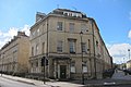
At over 1,000 feet (300 m) long and 100 feet (30 m) wide, the road itself is the widest and the grandest in Bath. However, the architect, Baldwin, designed only the façades of buildings. A variety of owners acquired plots of land along the new street and built the actual structures behind the façades, so that while the street has a visual external unity, the buildings have different internal features, some having been designed as private houses and others as hotels. Numbers 1 to 7 were a single government office, now designated as a Grade I listed building. [1] Numbers 41A and 42 to 77 have also been Grade I listed. [2]

It was foreseen that, along with the access provided by Pulteney Bridge, the eastern side of the Avon would become popular with speculators and developers. This appears not to have been the case, and in the event no further developments were made on this scale. Indeed, one of the side streets off Great Pulteney Street, called Sunderland Street, is the shortest street in the city, with only one address. After 1789, the financial climate did not encourage further building, as the Panic of 1797, related to a period of deflation between 1793 and 1800, was followed by the Napoleonic Wars and the Depression of 1807. Bath was also affected by a serious flood in 1809, [3] which would have inundated the basements in Great Pulteney Street as well as the surrounding fields.

When first built, the street was lined with trees, which in autumn caused some problems with leaf litter. When asked to solve this problem the town council opted to simply cut most of the trees down. In aerial photos held by Historic England [4] it can be seen that the trees were present from at least 1920 until 1953. The adjacent Laura Place had a much smaller number of trees which still remain.

The fountain area (also known as Laura Place) was initially not part of the original plan. After completion of the main street in 1877, local residents petitioned and successfully raised significant funds to build a grand column (rather like Nelson's Column in London). However, as construction of the column started, the residents realised that the addition would tower over the area (it would be 50% taller than the houses), and so they then petitioned for it to be cancelled. After some negotiations, the (half-built) column was pulled down and the much smaller fountain added instead. The centrepiece of the original Laura place fountain was damaged beyond repair during freshers' week in 1969 and replaced with a modern design in 1970.[ citation needed ]

Drawings of all the building plans (including many proposals that were never built) can be viewed in the Victoria Art Gallery situated on the corner of Pulteney Bridge and the Grand Parade.

In light of the Black Lives Matter movement in 2020, there has been some discussion of renaming the street in The Bath Magazine [5] and in Bath Newseum, [6] but so far no local consultation on this has actually started.

Architecture

The planning and frontage of the entire street was done by the architect Thomas Baldwin but construction of individual buildings was done by a number of local contractors. This system of town planning was also used at the nearby Royal Crescent. [7] In all major dimensions there is considerable conformity, the width and height of buildings and the size and spacing of windows all adhere to a grid pattern.

However a closer look will reveal many subtle differences:

The above points can be verified by examining the photographs of each building available on Wikimedia commons.

The pavement in Great Pulteney has mostly been replaced with modern reconstituted stone paving slabs, many of the surrounding streets (e.g. Sydney Place) still have the original solid stone flags.

Great Pulteney Street was intended to form the centre of a much larger geometrical layout of grand streets, squares and circuses. However, the scheme by Thomas Baldwin to create a whole new town south of the river was hit by financial panic as a result of the French Revolution and the collapse of many banks – including the one funding Baldwin's grand plans. [9]

In 2018 the majority of the front doors on the street are painted white. This is unlikely to have been the original finish as when new the grain and colour of wood was very much admired and was often left uncovered with just a sealing coat of varnish. As the original woodwork aged or became damaged the varnish would typically be replaced with an oil based brown or dark green paint. [10]

The numbering of the houses skips over the number 13, but there is a 10a and 10b.

Former notable residents

The below is a list of notable residents who have either lived on Great Pulteney Street or stayed there for an amount of time: [11]

Related Research Articles

<span class="mw-page-title-main">Bath, Somerset</span> City in Somerset, England

Bath is a city and unparished area in the Bath and North East Somerset unitary area in the ceremonial county of Somerset, England, known for and named after its Roman-built baths. At the 2021 Census, the population was 101,557. Bath is in the valley of the River Avon, 97 miles (156 km) west of London and 11 miles (18 km) southeast of Bristol. The city became a World Heritage Site in 1987, and was later added to the transnational World Heritage Site known as the "Great Spa Towns of Europe" in 2021. Bath is also the largest city and settlement in Somerset.

<span class="mw-page-title-main">Pulteney Bridge</span> Bridge over the River Avon in Bath, England

Pulteney Bridge is a bridge over the River Avon in Bath, England. It was completed by 1774, and connected the city with the land of the Pulteney family which it wished to develop. Designed by Robert Adam in a Palladian style, it is highly unusual in that it has shops built across its full span on both sides. It has been designated as a Grade I listed building.

<span class="mw-page-title-main">Lansdown Crescent, Bath</span> Row of buildings in Bath, England

Lansdown Crescent is a well-known example of Georgian architecture in Bath, Somerset, England, designed by John Palmer and constructed by a variety of builders between 1789 and 1793. The buildings have a clear view over central Bath, being sited on Lansdown Hill near to, but higher than, other well-known Georgian buildings including the Royal Crescent, St James's Square, Bath and The Circus, Bath. It forms the central part of a string of curved terraces, including Lansdown Place East and West, and Someset Place, which were the northernmost boundary of the development of Georgian Bath.

John Pinch was an architect working mainly in the city of Bath, England. He was surveyor to the Pulteney and Darlington estate and responsible for many of the later Georgian buildings in Bath, especially in Bathwick.

Thomas Baldwin was an English architect in the city of Bath, who was responsible for designing some of Bath's principal Georgian buildings.

<span class="mw-page-title-main">Grade I listed buildings in Somerset</span> Buildings of exceptional interest in Somerset

The Grade I listed buildings in Somerset, England, demonstrate the history and diversity of its architecture. The ceremonial county of Somerset consists of a non-metropolitan county, administered by Somerset County Council, which is divided into five districts, and two unitary authorities. The districts of Somerset are West Somerset, South Somerset, Taunton Deane, Mendip and Sedgemoor. The two administratively independent unitary authorities, which were established on 1 April 1996 following the breakup of the county of Avon, are North Somerset and Bath and North East Somerset. These unitary authorities include areas that were once part of Somerset before the creation of Avon in 1974.

<span class="mw-page-title-main">Widcombe, Bath</span> Human settlement in England

Widcombe is a district of Bath, England, immediately south-east of the city centre, across the River Avon.

<span class="mw-page-title-main">Grade I listed buildings in Bath and North East Somerset</span>

Bath and North East Somerset is a unitary authority created on 1 April 1996, following the abolition of the County of Avon, which had existed since 1974. Part of the ceremonial county of Somerset, Bath and North East Somerset occupies an area of 220 square miles (570 km2), two-thirds of which is green belt. It stretches from the outskirts of Bristol, south into the Mendip Hills and east to the southern Cotswold Hills and Wiltshire border. The city of Bath is the principal settlement in the district, but BANES also covers Keynsham, Midsomer Norton, Radstock and the Chew Valley. The area has a population of 170,000, about half of whom live in Bath, making it 12 times more densely populated than the rest of the area.

<span class="mw-page-title-main">Grand Pump Room</span> Historic building in the Abbey Churchyard, Bath, Somerset, England

The Grand Pump Room is a historic building in the Abbey Churchyard, Bath, Somerset, England. It is adjacent to the Roman Baths and is named for water that is pumped into the room from the baths' hot springs. Visitors can drink the water or have other refreshments while there.

<span class="mw-page-title-main">Gay Street, Bath</span> Historic site in Somerset, England

Gay Street in Bath, Somerset, England, links Queen Square to The Circus. It was designed by John Wood, the Elder in 1735 and completed by his son John Wood, the Younger. The land was leased to the elder Wood by Robert Gay, MP for Bath, and the street is named after him. Much of the road has been designated as Grade I listed buildings.

<span class="mw-page-title-main">Bath Street, Bath</span> Historic site in Somerset, England

Bath Street in Bath, Somerset, England was built by Thomas Baldwin in 1791. Several of the buildings have been designated as Grade I listed buildings.

<span class="mw-page-title-main">Duke Street, Bath</span> Historic site in Somerset, England

Duke Street in Bath, Somerset, England was built in 1748 by John Wood, the Elder. Several of the buildings have been designated as Grade I listed buildings. The street, which overlooks the River Avon, is pedestrianised with no vehicles permitted to enter.

<span class="mw-page-title-main">Sydney Place, Bath</span> Protected historic residential buildings

Sydney Place in the Bathwick area of Bath, Somerset, England was built around 1800. Many of the properties are listed buildings.

<span class="mw-page-title-main">North Parade, Bath</span> Street in Bath and North East Somerset, United Kingdom

North Parade in Bath, Somerset, England is a historic terrace built around 1741 by John Wood, the Elder. Several of the houses have been designated as Grade I listed buildings.

<span class="mw-page-title-main">South Parade, Bath</span> Historic site in Somerset, England

South Parade in Bath, Somerset, England, is a historic terrace built around 1743 by John Wood, the Elder. All of the houses have been designated as Grade I listed buildings.

<span class="mw-page-title-main">Laura Place, Bath</span> Historic site in Somerset, England

Laura Place Bathwick, Bath, Somerset, England, consists of four blocks of houses around an irregular quadrangle at the end of Pulteney Bridge. It was built by Thomas Baldwin and John Eveleigh between 1788 and 1794.

<span class="mw-page-title-main">Buildings and architecture of Bath</span> Permanent structures including significant examples of English architecture from the Roman Baths

The buildings and architecture of Bath, a city in Somerset in the south west of England, reveal significant examples of the architecture of England, from the Roman Baths, to the present day. The city became a World Heritage Site in 1987, largely because of its architectural history and the way in which the city landscape draws together public and private buildings and spaces. The many examples of Palladian architecture are purposefully integrated with the urban spaces to provide "picturesque aestheticism". In 2021, the city was added to a second World Heritage Site, a group of historic spa towns across Europe known as the "Great Spas of Europe". Bath is the only entire city in Britain to achieve World Heritage status, and is a popular tourist destination.

<span class="mw-page-title-main">Bath Abbey Cemetery</span> Cemetery in Bath and North East Somerset, UK

The Anglican Bath Abbey Cemetery, officially dedicated as the Cemetery of St Peter and St Paul, was laid out by noted cemetery designer and landscape architect John Claudius Loudon (1783–1843) between 1843 and 1844 on a picturesque hillside site overlooking Bath, Somerset, England.

<span class="mw-page-title-main">Sydney Gardens</span> Public open space in Bath, England

Sydney Gardens is a public open space at the end of Great Pulteney Street in Bath, Somerset, England. The gardens are the only remaining eighteenth-century pleasure gardens in the country. They are Grade II listed on the Register of Historic Parks and Gardens of special historic interest in England.

<span class="mw-page-title-main">Northam Post Office</span> Historic commonwealth heritage site in Northam, Western Australia

Northam Post Office is a heritage-listed post office at 239-243 Fitzgerald Street, Northam, Western Australia, Australia. It was added to the Australian Commonwealth Heritage List on 22 June 2004.

References

  1. "Nos 1 to 7 (consec) 12.6.50. Nos 8 to 10 (consec), 10A & 12.6.50. ll to 20 (consec) 14.7.55. No 21 12.6.50 Nos 22 to 3O (consec) Nos 31 to 34 (consec) 12.6.50. Nos 35 & 36 14.7.55. No 37 12.6.50. Nos 38 to 40 (consec) Great Pulteney Street". Images of England. English Heritage. Archived from the original on 6 October 2010. Retrieved 19 July 2009.
  2. "No 41A Nos 42 to 77 Great Pulteney Street". Images of England. English Heritage. Archived from the original on 6 October 2010. Retrieved 19 July 2009.
  3. Michael Forsyth, Structures & construction in historic building conservation (2007), p. 164
  4. "Historic England - Championing England's heritage | Historic England". historicengland.org.uk. Retrieved 20 April 2022.
  5. "The slave trade: Local truths". 26 July 2020.
  6. "How about William (Wilberforce) Street instead of Pulteney?". 17 June 2020.
  7. "Doors of Bath". 8 June 2013.
  8. "Bath in Time Image Library".
  9. "Pavement history". 17 November 2013.
  10. "A clash of colour in the Crescent!". 17 August 2012.
  11. "Bath-Heritage.co.uk". bath-heritage.co.uk. Retrieved 20 April 2022.

Coordinates: 51°23′04″N2°21′15″W / 51.3844°N 2.3543°W / 51.3844; -2.3543