
There are over 9000 Grade I listed buildings in England. This page is a list of the 215 Grade I listed buildings in the county of Hampshire. There are also five Grade I listed parks and gardens which are not listed here.
There are over 9000 Grade I listed buildings in England. This page is a list of the 215 Grade I listed buildings in the county of Hampshire. There are also five Grade I listed parks and gardens which are not listed here.
| Name | Location | Type | Completed [note 1] | Date designated | Grid ref. [note 2] Geo-coordinates | Entry number [note 3] | Image |
|---|---|---|---|---|---|---|---|
| Bargate and Guildhall | Southampton City Centre | Gate | 1180–1200 | 14 July 1953 | SU4199711636 50°54′10″N1°24′15″W / 50.902678°N 1.404128°W | 1092087 |  |
| Canute's Palace | Southampton City Centre | Hall house | Late 12th century | 14 July 1953 | SU4194811002 50°53′49″N1°24′18″W / 50.89698°N 1.404897°W | 1340013 |  |
| Church of St Julian | Southampton City Centre | Guest house | c. 1185 | 14 July 1953 | SU4204110951 50°53′47″N1°24′13″W / 50.896515°N 1.403581°W | 1091959 |  |
| Church of St Mary | Swaythling | Parish church | 12th century | 14 July 1953 | SU4398815421 50°56′12″N1°22′31″W / 50.936564°N 1.37536°W | 1179339 |  |
| Church of St Michael | Southampton City Centre | Parish church | c. 1070 | 14 July 1953 | SU4192711291 50°53′58″N1°24′19″W / 50.899581°N 1.405163°W | 1179142 |  |
| King John's Palace | Southampton City Centre | Merchants house | c. 1170 | 14 July 1953 | SU4182211285 50°53′58″N1°24′24″W / 50.899534°N 1.406656°W | 1339942 |  |
| God's House Gate | Southampton City Centre | Gate | c. 1300 | 14 July 1953 | SU4208810932 50°53′47″N1°24′10″W / 50.89634°N 1.40291°W | 1340004 |  |
| Section of Wall Running North from God's House Along Back of the Walls to Round Tower Adjacent to No 15 | Southampton City Centre | Angle tower | 13th century | 14 July 1953 | SU4209610976 50°53′48″N1°24′10″W / 50.896736°N 1.402796°W | 1091982 |  |
| Section of wall running west from Bargate to Arundel Tower and then south to point just south of Castle Water Gate. It includes Arundel Tower, Catchcold Tower, Garderobe Tower, the 40 Steps, Castle Water Gate and Castle Vault, the town walls, Bargate Street the West Gate including portions of town walls and arcades adjoining. | Southampton City Centre | Walls | Medieval | 14 July 1953 | SU4186411591 50°54′08″N1°24′22″W / 50.9023°N 1.4061°W | 1340005 | 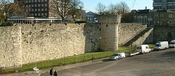 |
| Section of Wall Running West from Polymond Tower to Remains of Semi-circular Tower to East of Bargate and Small Part South of Polymond Tower | Southampton City Centre | Walls | Medieval | 14 July 1953 | SU4209211627 50°54′09″N1°24′10″W / 50.90259°N 1.402778°W | 1340006 |  |
| Sections of Wall Running South Along Esplanade from South-west Corner of Simnel Street to University Air Squadron Headquarters a | Southampton City Centre | Wall | Mid 14th century | 8 October 1981 | SU4180511253 50°53′57″N1°24′25″W / 50.899248°N 1.406902°W | 1179282 |  |
| The Wool House | Southampton City Centre | Storehouse | 14th century | 14 July 1953 | SU4186411064 50°53′51″N1°24′22″W / 50.897544°N 1.406084°W | 1092060 |  |
| Tudor House Museum | Southampton City Centre | Timber framed house | 1491–1518 | 14 July 1953 | SU4186911290 50°53′58″N1°24′22″W / 50.899576°N 1.405987°W | 1339964 |  |
| Medieval Merchant's House | Southampton City Centre | Merchants house | Late 13th century or early 14th century | 14 July 1953 | SU4191711180 50°53′55″N1°24′19″W / 50.898583°N 1.405317°W | 1092048 |  |
| Southampton Cenotaph | Southampton City Centre | Cenotaph | 1920 | 8 October 1981 | SU4191612408 50°54′35″N1°24′19″W / 50.90963°N 1.40519°W | 1340007 |  |
| Name | Location | Type | Completed [note 1] | Date designated | Grid ref. [note 2] Geo-coordinates | Entry number [note 3] | Image |
|---|---|---|---|---|---|---|---|
| Church of St Mary | Portchester, Fareham | Church | 1710 | 18 October 1955 | SU6253004495 50°50′12″N1°06′48″W / 50.836616°N 1.113376°W | 1339235 |  |
| Monastic Barn of Titchfield Abbey at Fern Hill Farm | Titchfield, Fareham | Tithe Barn | 15th century | 18 October 1955 | SU5395106489 50°51′19″N1°14′06″W / 50.855407°N 1.234901°W | 1094235 |  |
| Parish Church of St Peter | Titchfield, Fareham | Parish Church | Possible C8 origins | 18 October 1955 | SU5409305785 50°50′57″N1°13′59″W / 50.849064°N 1.232988°W | 1351279 |  |
| Portchester Castle | Portchester, Fareham | Castle | During reign of Henry II | 18 October 1955 | SU6241104667 50°50′17″N1°06′54″W / 50.838175°N 1.115036°W | 1229190 |  |
| Name | Location | Type | Completed [note 1] | Date designated | Grid ref. [note 2] Geo-coordinates | Entry number [note 3] | Image |
|---|---|---|---|---|---|---|---|
| Church of St Peter | Hayling Island, Havant | Parish Church | Transitional | 16 May 1952 | SU7308703201 50°49′25″N0°57′49″W / 50.823747°N 0.963737°W | 1155352 |  |
| Church of St Thomas à Becket | Warblington, Havant | Parish Church | Saxon | 16 May 1952 | SU7290005418 50°50′37″N0°57′57″W / 50.843703°N 0.965951°W | 1154443 |  |
| Name | Location | Type | Completed [note 1] | Date designated | Grid ref. [note 2] Geo-coordinates | Entry number [note 3] | Image |
|---|---|---|---|---|---|---|---|
| Church of the Blessed Virgin and Child | Beaulieu, New Forest | Church | Early/Mid 13th century | 8 October 1959 | SU3883202548 50°49′16″N1°27′00″W / 50.821179°N 1.450097°W | 1156943 |  |
| Domus and Ruins of Lay Frater | Beaulieu Manor Estate, Beaulieu, New Forest | Abbey | Late 13th century | 8 October 1959 | SU3879602579 50°49′17″N1°27′02″W / 50.82146°N 1.450604°W | 1156631 |  |
| Palace House | Beaulieu Manor Estate, Beaulieu, New Forest | Abbey | Mid 14th century | 8 October 1959 | SU3873002445 50°49′13″N1°27′06″W / 50.82026°N 1.451555°W | 1094430 |  |
| Remains of Outer Wall Around Cloister and Foundations of Abbey Church | Beaulieu Manor Estate, Beaulieu, New Forest | Abbey | Late 13th century | 8 October 1959 | SU3883002591 50°49′18″N1°27′00″W / 50.821566°N 1.45012°W | 1094429 |  |
| Remains of St Leonard's Chapel | St Leonard's, Beaulieu, New Forest | Chapel | 14th century | 8 October 1959 | SZ4052798207 50°46′55″N1°25′35″W / 50.782029°N 1.426513°W | 1094415 |  |
| St Leonard's Barn | St Leonard's, Beaulieu, New Forest | Barn | 14th century | 8 October 1959 | SZ4064898164 50°46′54″N1°25′29″W / 50.781633°N 1.424801°W | 1157008 |  |
| Hinton Admiral House | Hinton Park, Bransgore, New Forest | Country House | 1720 | 30 September 1964 | SZ2085395944 50°45′46″N1°42′21″W / 50.762716°N 1.7057°W | 1095030 |  |
| Church of St Mary | Breamore Park, Breamore, New Forest | Parish Church | Late 10th century | 30 September 1964 | SU1532818896 50°58′09″N1°46′59″W / 50.96928°N 1.783081°W | 1094934 |  |
| Church of St George | Damerham, New Forest | Parish Church | 12th century | 13 February 1987 | SU1075315809 50°56′30″N1°50′54″W / 50.941624°N 1.848326°W | 1094925 |  |
| Church of St Mary | Ellingham, New Forest | Parish Church | 13th century | 30 September 1964 | SU1442508323 50°52′27″N1°47′47″W / 50.874228°N 1.796356°W | 1156533 |  |
| Church of All Saints | Fawley, New Forest | Tower | c. 1175 | 8 October 1959 | SU4575403553 50°49′47″N1°21′06″W / 50.829712°N 1.351711°W | 1351239 |  |
| Church of St Mary | Fordingbridge, New Forest | Parish Church | 12th century | 30 September 1964 | SU1451513813 50°55′25″N1°47′41″W / 50.923594°N 1.79486°W | 1350974 |  |
| Church of St Mary | Hale Park, Hale, New Forest | Parish Church | Medieval origins | 30 September 1964 | SU1784218655 50°58′01″N1°44′50″W / 50.967041°N 1.747291°W | 1094881 |  |
| Hale House, Including Quadrant Passages to Pavilions | Hale Park, Hale, New Forest | Country House | 1715 | 30 April 1955 | SU1794718577 50°57′59″N1°44′45″W / 50.966337°N 1.745799°W | 1301070 | 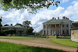 |
| Church of St Michael and All Angels | Lyndhurst, New Forest | Parish Church | 1858-68 | 13 May 1987 | SU2980508168 50°52′20″N1°34′40″W / 50.872249°N 1.577787°W | 1094725 |  |
| Church of All Saints | Martin, New Forest | Parish Church | 12th century | 30 September 1964 | SU0705019559 50°58′31″N1°54′03″W / 50.975401°N 1.900958°W | 1094828 |  |
| Church of All Saints | Milford-on-Sea, New Forest | Church | late Norman | 22 December 1973 | SZ2905592109 50°43′40″N1°35′23″W / 50.727879°N 1.589711°W | 1276161 |  |
| Church of All Saints | Minstead, New Forest | Church | Early 19th century | 8 October 1959 | SU2810510878 50°53′48″N1°36′06″W / 50.896702°N 1.601739°W | 1094732 |  |
| Barn Formerly Chapel 20 Metres East of Manor House | Manor Farm, Rockbourne, New Forest | Chapel | 13th century | 30 September 1964 | SU1156318371 50°57′53″N1°50′12″W / 50.964647°N 1.836716°W | 1167857 |  |
| Church of St Andrew | Manor Farm, Rockbourne, New Forest | Parish Church | 13th century | 30 September 1964 | SU1155818319 50°57′51″N1°50′12″W / 50.964179°N 1.836789°W | 1296677 |  |
| Large Barn 50 Metres North East of Manor House | Manor Farm, Rockbourne, New Forest | House | 15th century | 30 September 1964 | SU1155818395 50°57′54″N1°50′12″W / 50.964863°N 1.836787°W | 1351003 |  |
| Manor Farm and Wall Running North East | Manor Farm, Rockbourne, New Forest | Hall House | 14th century | 30 September 1964 | SU1153418341 50°57′52″N1°50′14″W / 50.964377°N 1.83713°W | 1351002 |  |
| Avon Tyrrell House | Avon Tyrrell, Sopley, New Forest | Country House | 1891 | 12 March 1987 | SU1853100257 50°48′06″N1°44′18″W / 50.801579°N 1.738406°W | 1350922 |  |
| Church of All Saints | Thorney Hill, Sopley, New Forest | Church | 1906 | 24 September 1985 | SZ1970099724 50°47′48″N1°43′19″W / 50.796748°N 1.721846°W | 1302198 |  |
| Name | Location | Type | Completed [note 1] | Date designated | Grid ref. [note 2] Geo-coordinates | Entry number [note 3] | Image |
|---|---|---|---|---|---|---|---|
| Abbey Church of St Michael | Rushmoor | Church | 1886-7 | 28 January 1959 | SU8727856078 51°17′50″N0°44′58″W / 51.29715°N 0.749572°W | 1155639 |  |
| Building Q121 at Former Royal Aircraft Establishment Site | Rushmoor | Workshop | 1934–1935 | 4 December 1996 | SU8678754709 51°17′06″N0°45′25″W / 51.284918°N 0.756945°W | 1259589 |  |
| Building R133 at Former Royal Aircraft Establishment site | Rushmoor | Test House | 1939–1942 | 4 December 1996 | SU8686154824 51°17′09″N0°45′21″W / 51.28594°N 0.755856°W | 1259586 |  |
| Main Building to Farnborough Hill Convent | Rushmoor | House | 1863 | 13 November 1975 | SU8718856449 51°18′02″N0°45′03″W / 51.300498°N 0.750772°W | 1303116 |  |
| Name | Location | Type | Completed [note 1] | Date designated | Grid ref. [note 2] Geo-coordinates | Entry number [note 3] | Image |
|---|---|---|---|---|---|---|---|
| Church of St Mary the Virgin | Abbotts Ann, Test Valley | Parish Church | 1716 | 20 December 1960 | SU3304343575 51°11′26″N1°31′43″W / 51.190449°N 1.528553°W | 1228703 | 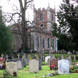 |
| Church of St Mary the Less | Chilbolton, Test Valley | Parish Church | Norman | 20 December 1960 | SU3948140219 51°09′36″N1°26′12″W / 51.159866°N 1.436801°W | 1339283 |  |
| Church of St Michael and All Angels | Knights Enham, Enham Alamein, Test Valley | Church | Norman | 24 February 1950 | SU3618048075 51°13′51″N1°29′00″W / 51.230722°N 1.483214°W | 1093461 |  |
| Church of St Peter | Goodworth Clatford, Test Valley | Parish Church | Norman | 20 December 1960 | SU3661542533 51°10′51″N1°28′39″W / 51.180863°N 1.477548°W | 1339285 |  |
| Church of St Leonard | Grateley, Test Valley | Parish Church | Norman | 24 October 1984 | SU2756241970 51°10′35″N1°36′26″W / 51.176307°N 1.607104°W | 1093259 |  |
| Church of St Peter | Hurstbourne Tarrant, Test Valley | Parish Church | Late 12th century | 20 December 1960 | SU3852452990 51°16′29″N1°26′57″W / 51.274761°N 1.449117°W | 1093367 |  |
| Church of St Peter and St Paul | Kimpton, Test Valley | Church | 13th century | 21 December 1960 | SU2811446625 51°13′05″N1°35′56″W / 51.218136°N 1.598845°W | 1093222 |  |
| Marshcourt School | Marsh Court, King's Somborne, Test Valley | Country House | 1901–5 | 29 May 1957 | SU3566033594 51°06′02″N1°29′32″W / 51.100546°N 1.492092°W | 1093803 |  |
| Church of St Nicholas | Middleton, Longparish, Test Valley | Parish Church | c. 1200 | 20 December 1960 | SU4257043907 51°11′34″N1°23′32″W / 51.192806°N 1.392195°W | 1339297 |  |
| Church of St Andrew | Mottisfont, Test Valley | Parish Church | 12th century | 29 May 1957 | SU3259426749 51°02′21″N1°32′11″W / 51.039179°N 1.536493°W | 1172913 |  |
| Mottisfont Abbey House | Mottisfont Abbey, Mottisfont, Test Valley | Country House | 16th century | 29 May 1957 | SU3270426965 51°02′28″N1°32′06″W / 51.041115°N 1.534905°W | 1093730 |  |
| Barn 40 Metres East of Berry Court Farmhouse | Nether Wallop, Test Valley | Farmyard | 15th century | 27 November 1984 | SU3023735638 51°07′09″N1°34′10″W / 51.119236°N 1.569369°W | 1339452 |  |
| Church of St Andrew | Nether Wallop, Test Valley | Parish Church | 11th century | 29 May 1957 | SU3039636398 51°07′34″N1°34′01″W / 51.126062°N 1.567033°W | 1339423 |  |
| Grove Place House, Northcliffe School | Grove Place, Nursling and Rownhams, Test Valley | Country House | Mid 16th century | 29 May 1957 | SU3668016759 50°56′57″N1°28′45″W / 50.949105°N 1.479224°W | 1339157 |  |
| Abbey Church of St Mary | Romsey, Test Valley | Abbey | until circa 1230 | 28 August 1951 | SU3509321257 50°59′23″N1°30′05″W / 50.989649°N 1.501382°W | 1092649 |  |
| King John's House | Romsey, Test Valley | Abbey | Medieval | 28 August 1951 | SU3521921280 50°59′23″N1°29′59″W / 50.989848°N 1.499584°W | 1231745 |  |
| Broadlands House | Broadlands Estate, Romsey Extra, Test Valley | Country House | Elizabethan | 29 May 1957 | SU3539120242 50°58′50″N1°29′50″W / 50.980504°N 1.497234°W | 1166489 | 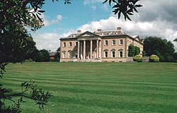 |
| Middle Bridge | Romsey Extra, Test Valley | Bridge | 1788 | 28 August 1951 | SU3492220680 50°59′04″N1°30′14″W / 50.984471°N 1.503873°W | 1339680 |  |
| Church of St Peter and St Paul | Thruxton, Test Valley | Parish Church | 13th century | 20 December 1960 | SU2888445588 51°12′32″N1°35′16″W / 51.208774°N 1.587903°W | 1093204 | 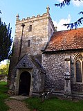 |
| Church of St Margaret | Wellow, Test Valley | Parish Church | Early 13th century | 29 May 1957 | SU3028620397 50°58′56″N1°34′12″W / 50.982188°N 1.569939°W | 1339214 |  |
| Stable Block (30 Yards South of Wherwell Priory) | Wherwell, Test Valley | Abbey | 2nd quarter of 13th century | 21 March 1984 | SU3917740671 51°09′50″N1°26′28″W / 51.163951°N 1.441099°W | 1093391 |  Upload Photo |
![]() Media related to Grade I listed buildings in Hampshire at Wikimedia Commons
Media related to Grade I listed buildings in Hampshire at Wikimedia Commons


