Dummer, Hampshire

Last updated

Dummer
Dummer church.jpg
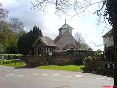
All Saints' Church, Dummer
Hampshire UK location map.svg
Red pog.svg
Dummer
Location within Hampshire
Population466 (2011 Census including Popham) [1]
OS grid reference SU583458
Civil parish
  • Dummer
District
Shire county
Region
Country England
Sovereign state United Kingdom
Post town BASINGSTOKE
Postcode district RG25
Dialling code 01256
Police Hampshire and Isle of Wight
Fire Hampshire and Isle of Wight
Ambulance South Central
UK Parliament
List of places
UK
England
Hampshire
51°12′37″N1°09′40″W / 51.2102°N 1.1611°W / 51.2102; -1.1611

Dummer is a parish and village in Hampshire, England. It is 6 miles south-west of Basingstoke and near Junction 7 on the M3 motorway.

Contents

In the 2001 census, it had a population of 643, with 127 dwellings, [2] reducing to a population of 466 in 201 households at the 2011 Census. [1]

History

The name of the village is derived from Dun (meaning hill) and Mer (lake or pond).[ citation needed ] The English surname 'Dummer' is thought to originate from here, as the Dummer family were lords of the manor between the 12th and 16th centuries.[ citation needed ]

All Saints Church is in the centre of the village. [3] The church is part of the Church of England benefice of Farleigh, Candover and Wield, served by the same Rector.

A public house, The Queen Inn, is north of the church on Down Street towards the M3. [4]

Also towards the M3 is the Dummer Golf Club, the course lying to the northeast of the village. [5]

On the other side of the M3 north of the A30 is the Dummer Garden Centre, [6] and a public house, The Sun Inn. A short distance south-west down the A30 is another public house and hotel, The Wheatsheaf. [7]

To the south-west of Dummer village by about 34 mile (1.2 km) is Dummer Down Farm. This is the site of the Dummer Cricket Centre which was founded by Major Ronald Ferguson, father of Sarah, Duchess of York. [8] The current owner, Andrew Ferguson, was a local councillor on Dummer Parish Council.

Governance

The village is part of the civil parish of Dummer, [9] which is part of the Oakley and North Waltham ward of Basingstoke and Deane borough council. [10] The borough council is a non-metropolitan district of Hampshire County Council.

Location

Notable people

Related Research Articles

<span class="mw-page-title-main">Little London, Tadley, Hampshire</span> Human settlement in England

Little London is a village situated between the North Hampshire Downs and the gravel plains of the Kennet valley, 7 miles (11 km) north of Basingstoke and 15 miles (24 km) south of Reading. It is situated within Pamber civil parish and backs on to Pamber Forest, a 500-acre (2.0 km2) SSSI and remnant of the much larger ancient Royal Forest of Pamber. It is recorded as having been established for at least 400 years.

<span class="mw-page-title-main">Basingstoke</span> Town in England

Basingstoke is a town in Hampshire, situated in south-central England across a valley at the source of the River Loddon on the western edge of the North Downs. It is the largest settlement in Hampshire without city status. It is located 30 miles (48 km) north-east of Southampton, 48 miles (77 km) south-west of London, 27 miles (43 km) west of Guildford, 22 miles (35 km) south of Reading and 20 miles (32 km) north-east of the county town and former capital Winchester. According to the 2016 population estimate, the town had a population of 113,776. It is part of the borough of Basingstoke and Deane and part of the parliamentary constituency of Basingstoke.

<span class="mw-page-title-main">Oakley, Hampshire</span> Human settlement in England

Oakley is a village in the borough of Basingstoke and Deane in Hampshire, England, located around 4.5 miles (7 km) west of Basingstoke. In the 2001 Census it had a population of 5,322. Together with the smaller village of Deane, it forms the Oakley and Deane civil parish renamed as Oakley at the 2011 Census.

<span class="mw-page-title-main">Overton, Hampshire</span> Human settlement in England

Overton is a large village and parish in Hampshire, England located west of the town of Basingstoke, and east of Andover and Whitchurch. The village contains smaller hamlets of Southington, Northington, Ashe, Polhampton, and Quidhampton, the latter two lying to the north of the village. The River Test has its source 1 mile (1.6 km) to the east in Ashe.

Hook is a large village and civil parish in the Hart District of northern Hampshire, England.

<span class="mw-page-title-main">Steventon, Hampshire</span> Human settlement in England

Steventon is a village and a civil parish with a population of about 250 in north Hampshire, England. Situated 7 miles south-west of the town of Basingstoke, between the villages of Overton, Oakley and North Waltham, it is close to Junction 7 of the M3.

<span class="mw-page-title-main">North Waltham</span> Human settlement in England

North Waltham is a village and civil parish in the borough of Basingstoke and Deane in Hampshire, England. It is located around 6 miles (9.7 km) southwest of Basingstoke and just north of the M3 motorway. In the 2011 Census it had a population of 870. The village is home to a pond, shop, Victorian primary school, a recreation ground and two pubs: The Fox, and The Wheatsheaf. The Church of England Parish Church is dedicated to St Michael.

<span class="mw-page-title-main">Cliddesden</span> Human settlement in England

Cliddesden is a village and a parish in Hampshire, England located 3 miles south of Basingstoke, close to the M3 motorway. In the 2001 census it had a population of 489, increasing to 497 at the 2011 Census. The land and housing are currently protected as it is within a Conservation Zone and has many areas of beauty and rolling countryside.

Kempshott is a ward of Basingstoke on the western edge of the town, to the south of Pack Lane and north of Winchester Road. The population of the ward at the 2011 Census was 6,827.

<span class="mw-page-title-main">Deane, Hampshire</span> Human settlement in England

Deane is a village and civil parish in the county of Hampshire, England. Its name appears in the name of the borough in which it is placed, Basingstoke and Deane.

Charles Anthony Palmer-Tomkinson is an English landowner and philanthropist, a former Olympic skier, and a close friend of King Charles III.

<span class="mw-page-title-main">Chineham</span> Human settlement in England

Chineham is a civil parish on the outskirts of Basingstoke, Hampshire, England. It is situated about 3 miles (5 km) northeast of central Basingstoke, just north of the A33 road between Basingstoke and Reading.

Ellisfield is a village in the Basingstoke and Deane district of Hampshire, England. It lies approximately 4 miles (6.4 km) south of Basingstoke on the other side of the M3 motorway from the town. As a parish it is grouped together with Cliddesden, Dummer and Farleigh Wallop.

<span class="mw-page-title-main">Andwell</span> Human settlement in England

Andwell is a village and former civil parish, now in the parish of Mapledurwell and Up Nately, in the Basingstoke and Deane district of Hampshire, England. Its former range was divided by the M3 motorway; it is also bounded to the north by the A30 road. Winchester College has owned land in the village since the 1390s. In 1931 the parish had a population of 20.

<span class="mw-page-title-main">Wootton St Lawrence</span> Human settlement in England

Wootton St Lawrence is a small village in the civil parish of Wootton St Lawrence with Ramsdell, in Hampshire, England, 2.5 miles (4.0 km) west of Basingstoke. The name is derived from the Old English wudu tun meaning woodland settlement or farm.

Malshanger is a small village in the Basingstoke and Deane district of Hampshire, England. Its nearest town is Basingstoke, which lies approximately 4.5 miles (7.1 km) south-east from the village.

Newfound is a hamlet in the Basingstoke and Deane district of Hampshire, England. Its nearest town is Basingstoke, which lies approximately 4.1 miles (6.6 km) east from the hamlet.

<span class="mw-page-title-main">North Oakley</span> Human settlement in England

North Oakley is a hamlet in the civil parish of Hannington in the Basingstoke and Deane district of Hampshire, England. Its nearest town is Tadley, which lies approximately 6.4 miles (10.3 km) north-east from the village.

<span class="mw-page-title-main">Popham, Hampshire</span> Human settlement in England

Popham is a hamlet and civil parish south of Basingstoke, Hampshire, England. According to the Post Office the population of the 2011 Census was included in the civil parish of Dummer. The area was occupied from pre-historic times and was established as a permanent habitation during the Roman occupation of Britain. The manor of Popham was established by the monastery of Winchester as an outlying agricultural grain station. A small church and school were later established, but have long since disappeared. The parish and hamlet were later dissected by the M3 Motorway and A303 trunk road. Although named for Popham, Popham Airfield and the Popham Little Chef restaurant are situated in the neighbouring parish of Steventon.

References

  1. 1 2 "Civil Parish population 2011". Neighbourhood Statistics. Office for National Statistics. Retrieved 14 December 2016.
  2. Hantsweb Team (2006). "Dummer". Hantsweb. Archived from the original on 8 August 2007. Retrieved 20 February 2007.
  3. www.allsaintschurchdummer.hampshire.org.uk|
  4. "The Queen Inn". The Queen Inn.
  5. "Home :: Dummer Golf Club". www.dummergolfclub.com.
  6. "Error | Deloitte UK".
  7. "Hampshire - Pubs and Inns with a literary connection". www.homesteadbb.free-online.co.uk.
  8. "Dummer Cricket Centre, Basingstoke, Hampshire". Serious Cricket.
  9. "Hampshire County Council's legal record of public rights of way in Hampshire" (PDF). 2008. Retrieved 22 November 2010.
  10. "Basingstoke and Deane Wards info". 2010. Archived from the original on 24 October 2010. Retrieved 22 November 2010.