Aldermaston is a village and civil parish in Berkshire, England. In the 2011 census, the parish had a population of 1,015. The village is in the Kennet Valley and bounds Hampshire to the south. It is approximately 8 miles (13 km) from Newbury, Basingstoke, and Reading and is 46 miles (74 km) from London.

Combe is a village and civil parish in the English county of Berkshire. The parish is situated on the top of the North Hampshire Downs near Walbury Hill and Combe Gibbet, overlooking the village of Inkpen and the valley of the River Kennet. In Walbury Hill, it includes the highest natural point in South East England.

Theale is a village and civil parish in West Berkshire, England. It is 5 miles (8 km) southwest of Reading and 10 miles (16 km) east of Thatcham. The compact parish is bounded to the south and south-east by the Kennet & Avon Canal, to the north by a golf course, to the east by the M4 motorway and to the west by the A340 road.

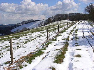
Walbury Hill is a summit of the North Wessex Downs in Berkshire, England. With an elevation of 297 metres (974 ft), it is the highest natural point in South East England. On the hill's summit is the Iron Age hill fort of Walbury Camp, whilst the flanks of the hill lie within the Inkpen and Walbury Hills SSSI. The hill is one of three nationally important chalk wild grasslands in the North Wessex Downs, the others being in the Rushmore and Conholt Downs SSSI and the Hog's Hole SSSI. The summit of the hill is marked by a triangulation pillar, but lies on private land with no public access, although public access is available to the north of the summit via a byway.

Enborne is a village and civil parish, in West Berkshire, England. The River Enborne shares its name, although it does not run through the village; rather, it runs through and rises near the nearby village of Enborne Row. The village name has had many variant spellings in the past, including Anebourne in 1086, as well as Enbourne, Enborn and Enbourn in the last 200 years.

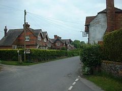
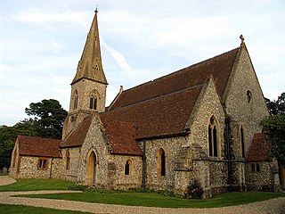
Beech Hill is a small village and civil parish in Berkshire, England. It is in the south east of the West Berkshire unitary authority area and bounds Hampshire and Wokingham district.

Boxford is a village and civil parish in the unitary authority of West Berkshire, England. The village is on the east bank of the River Lambourn, about 4 miles (6.4 km) northwest of Newbury but south of the M4 motorway. The hamlet of Westbrook is on the opposite bank of the Berkshire Downs tributary.

East Ilsley is a village and civil parish in the Berkshire Downs in West Berkshire, north of Newbury. The village is centred immediately east of the A34 dual carriageway which passes the length of the village from north to south. It has the vast majority of its buildings in a traditional clustered centre.
Pilot Hill is the highest summit in Hampshire, England, with a maximum elevation of 286 m (938 ft). It lies around 2 miles (3.2 km) to the south-east of Walbury Hill, the county top of Berkshire, which is 297 m (974 ft) high.

Great Shefford is an English village and civil parish on the River Lambourn in the West Berkshire district of Berkshire. The present civil parish includes the historical parish of Little or East Shefford, a small, reduced community downstream. It also covers the village of Shefford Woodlands, about 1.5 miles (2.4 km) south-west of Great Shefford, near Junction 14 on the M4 motorway.

Brimpton is a mostly rural village and civil parish in West Berkshire, England. Brimpton is centred 4.5 miles (7.2 km) ESE of the town of Newbury.

West Woodhay ( "woody") is a rural scattered village and civil parish in West Berkshire, England. At the 2011 census it had 59 households.
Ashmansworth is a village and civil parish in the Basingstoke and Deane district of the English county of Hampshire.
Burghclere is a village and civil parish in Hampshire, England. According to the 2011 census the village had a population of 1,152. The village is near the border of Hampshire with Berkshire, four miles south of Newbury. It is also very close to Newtown and Old Burghclere.

Highclere is a village and civil parish situated in the North Wessex Downs in the Basingstoke and Deane district of Hampshire, England. It lies in the northern part of the county, near the Berkshire border. It is most famous for being the location of Highclere Castle, a noted Victorian house of the Earl of Carnarvon. It is the setting for numerous films and TV series, including Downton Abbey.

Old Burghclere is part of Burghclere in Hampshire, England, located south of the large town of Newbury near the A34 road. The village of Burghclere, but less so Old Burghclere, was once on the A34 and has now been by-passed, although this section is not really part of the Newbury bypass.

Woodhay railway station was a station on the Didcot, Newbury and Southampton Railway in England. It was located about five miles south of the junction with the Great Western Railway west of Newbury railway station. Woodhay station served the villages of Enborne and Enborne Row in Berkshire and Broad Laying in the parish of East Woodhay, Hampshire. It was a considerable distance from the villages of East Woodhay and West Woodhay. The site now lies under the A34 Newbury by-pass.
Woolton Hill is a village in Hampshire, England, in the civil parish of East Woodhay. The village lies approximately 4 miles (6 km) south-west of the centre of Newbury and encompasses the hamlet of Broad Layings on its northern edge.

West Woodhay Down is a 1.5-hectare (3.7-acre) biological Site of Special Scientific Interest in Berkshire and Hampshire. It is lowland Calcareous grassland with a northwest facing bank, and forms part of the northern slopes of Walbury Hill and Combe Hill. The site was formerly included as part of Inkpen and Walbury Hills SSSI.

Combe Hill is a summit in Berkshire, England, with a maximum elevation of 293 m (961 ft). It lies around 1 mile (1.6 km) to the south-east of Walbury Hill, the county top of Berkshire, which is 297 m (974 ft) high. The hill is about 7 miles (11 km) southwest of Newbury on the Hampshire/Berkshire border and is part of the north-facing scarp of the North Hampshire Downs, a chalk ridge within the North Wessex Downs Area of Outstanding Natural Beauty.