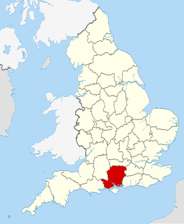
Litchfield is a village in the Basingstoke and Deane district of Hampshire, England. It is closely bypassed by the A34 trunk road between Newbury and Whitchurch, which follows the course of the former Didcot, Newbury and Southampton Railway. Litchfield railway station, which closed in 1960, was on this line. The station is a private house, not owned by C.A.H Wills who owns Litchfield farms estate and lives in the village. The station was sold by Hampshire County Council in 1978 and has been restored. The approach road is now a private drive to the property. In 1976 the Litchfield - Whitchurch bypass was opened and made use of the DN&SR trackbed south of Litchfield towards Whitchurch for a distance of one mile.

Deane is a village and civil parish in the county of Hampshire, England. Its name appears in the name of the borough in which it is placed, Basingstoke and Deane.

Bramley Corner is a village in Hampshire, England.
Bramley Green is a small village in the civil parish of Bramley in the Basingstoke and Deane district of Hampshire, England. It lies approximately 4 miles (6.4 km) south-east from the village of Bramley.

Andwell is a village in the Basingstoke and Deane district of Hampshire, England.

Ashe is a village in the Basingstoke and Deane district of Hampshire, England. The River Test commonly rises in the village.

Brown Candover is a village in Hampshire, England. The village belongs to the parish of the Candovers and its nearest town is New Alresford, 5 miles (8.0 km) away from the village.

Ashford Hill is a village in Basingstoke and Deane, Hampshire, England.

Ashe Warren is a village in the Basingstoke and Deane district of Hampshire, England. The settlement is within the civil parish of Overton, and is located approximately 6.3 miles (10.1 km) west of Basingstoke.
Binley is a village in Hampshire, England. The village lies near the A34 road between Whitchurch and Stockbridge. Its nearest town is Whitchurch, which lies approximately 4.4 miles (7.1 km) south-east from the village.

Cole Henley is a hamlet in the Basingstoke and Deane district of Hampshire, England. Its nearest town is Whitchurch, which lies approximately 3.1 miles (5.0 km) south-east from the hamlet, just off the A34 road.
Lower Wyke is a small village in the Basingstoke and Deane district of Hampshire, England. It is in the civil parish of St. Mary Bourne. Its nearest town is Andover, which lies approximately 3.6 miles (5.8 km) south-east from the village.
Malshanger is a small village in the Basingstoke and Deane district of Hampshire, England. Its nearest town is Basingstoke, which lies approximately 4.5 miles (7.1 km) south-east from the village.
Middle Wyke is a hamlet in the Basingstoke and Deane district of Hampshire, England. Its nearest town is Andover, which lies approximately 3.7 miles (6.1 km) south-west from the hamlet.
Newfound is a hamlet in the Basingstoke and Deane district of Hampshire, England. Its nearest town is Basingstoke, which lies approximately 4.1 miles (6.6 km) east from the hamlet.

North Oakley is a hamlet in the civil parish of Hannington in the Basingstoke and Deane district of Hampshire, England. Its nearest town is Tadley, which lies approximately 6.4 miles (10.3 km) north-east from the village.
North Sydmonton is a small village in the Basingstoke and Deane district of Hampshire, England. Its nearest town is Newbury, which lies approximately 4.3 miles (6.9 km) north-west from the village.
Nutley is a small village and civil parish in the Basingstoke and Deane district of Hampshire, England. It is located approximately 5.6 miles (9.0 km) south-west from Basingstoke, just off the B3046 road. The parish has an acreage of 1,524 acres (617 ha) with 74 acres (30 ha) made up of permanent grass and 386 acres (156 ha) of woodland.
Brock's Green is a small village in the Basingstoke and Deane district of Hampshire, England. Its nearest town is Newbury, which lies approximately 4.7 miles (7.6 km) north-west from the village.
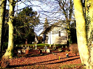
Stoke is a small village in northwest Hampshire. At the 2011 Census the population of the village was included in the civil parish of St Mary Bourne. It lies in the valley of the Bourne Rivulet, a tributary of the River Test 5 miles (8.0 km) northeast of the town of Andover.