
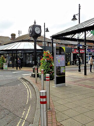
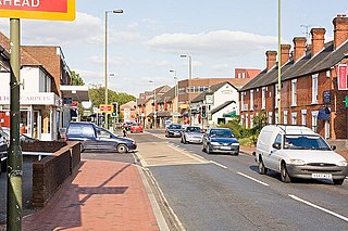
Romsey is a town in the Test Valley district of Hampshire, England. The town is situated 7 miles (11 km) northwest of Southampton, 11 miles (18 km) southwest of Winchester and 17 miles (27 km) southeast of Salisbury. It sits on the outskirts of the New Forest, just over 3 miles (4.8 km) northeast of its eastern edge. The population of Romsey was 14,768 at the 2011 census.

Nursling is a village in the civil parish of Nursling and Rownhams, in the Test Valley district, in Hampshire, England, about 6 kilometres north-west of the city of Southampton. Formerly called Nhutscelle, then Nutsall, Nutshalling or Nutshullyng until the mid-19th century, it has now been absorbed into the suburbs of Southampton, although it is not part of the district of Southampton.

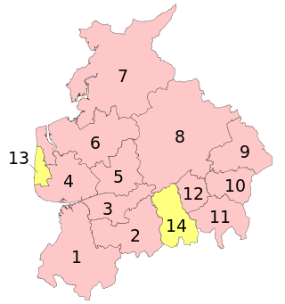
Basingstoke and Deane is a local government district with borough status in Hampshire, England. The main town is Basingstoke, where the council is based. The district also includes the towns of Tadley and Whitchurch, along with numerous villages and surrounding rural areas. The modern district was created in 1974, initially being called Basingstoke. It changed its name to "Basingstoke and Deane" in 1978 at the same time that it was made a borough; Deane was added to the name to represent the rural parts of the borough, being the area's smallest village.

Test Valley is a local government district with borough status in Hampshire, England, named after the valley of the River Test. The council is based in the borough's largest town of Andover. The borough also contains the town of Romsey and numerous villages and surrounding rural areas. A small part of the borough at its southern end lies within the New Forest National Park, and part of the borough north of Andover lies within the North Wessex Downs, a designated Area of Outstanding Natural Beauty.
The Borough of Eastleigh is a local government district with borough status in Hampshire, England. It is named after its main town of Eastleigh, where the council is based. The borough also contains the town of Hedge End along with several villages, many of which form part of the South Hampshire urban area.
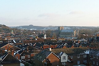
Winchester, or the City of Winchester, is a local government district with city status in Hampshire, England.

A civil parish is a country subdivision, forming the lowest unit of local government in England. There are 125 civil parishes in the ceremonial county of Bedfordshire, most of the county being parished: Luton is completely unparished; Central Bedfordshire is entirely parished. At the 2001 census, there were 312,301 people living in the 125 parishes, which accounted for 55.2 per cent of the county's population.

A civil parish is a country subdivision, forming the lowest unit of local government in England. There are 264 civil parishes in the ceremonial county of Cambridgeshire, most of the county being parished; Cambridge is completely unparished; Fenland, East Cambridgeshire, South Cambridgeshire and Huntingdonshire are entirely parished. At the 2001 census, there were 497,820 people living in the parishes, accounting for 70.2 per cent of the county's population.

A civil parish is a country subdivision, forming the lowest unit of local government in England. There are 333 civil parishes in the ceremonial county of Cheshire, most of the county being parished. Cheshire East unitary authority is entirely parished. At the 2001 census, there were 565,259 people living in 332 parishes, accounting for 57.5 per cent of the county's population.
A civil parish is a subnational entity, forming the lowest unit of local government in England. There are 219 civil parishes in the ceremonial county of Lancashire; Blackpool is completely unparished; Pendle and Ribble Valley are entirely parished. At the 2001 census, there were 587,074 people living in the 219 parishes, accounting for 41.5 per cent of the county's population.

Timsbury is a village and former civil parish, now in the parish of Michelmersh and Timsbury, in the Test Valley district, in Hampshire, England. It is near the town of Romsey, mainly along the A3057 road running north from Romsey towards Stockbridge, and shares a boundary with the village of Michelmersh.

Michelmersh is a village and former civil parish, now in the parish of Michelmersh and Timsbury, in the Test Valley district, in the county of Hampshire, England. It is 3 miles (4.8 km) north of Romsey.

Eastleigh is a constituency represented in the House of Commons of the UK Parliament since 2024 by Liz Jarvis, a Liberal Democrat.
Chandler's Ford is a largely residential area and civil parish in the Borough of Eastleigh in Hampshire, England. It had a population of 21,436 in the 2011 Census.

Stockbridge is a town and civil parish in the Test Valley district of Hampshire, England. It had a population of 592 at the 2011 census. It sits astride the River Test and at the foot of Stockbridge Down.

North Baddesley is a large village and civil parish in Hampshire, England. It is situated 3 mi (5 km) east of the town of Romsey and 6 mi (10 km) north of Southampton. It occupies an area of approximately 9.15 km2 (3.53 sq mi), and is home to a population of just over 10,000 people, reducing to 7,000 at the 2011 Census. It is located in the Test Valley; a river famous for trout fishing.

Romsey and Southampton North is a constituency represented in the House of Commons of the UK Parliament since its 2010 creation by Caroline Nokes for the Conservative Party. For the purposes of election expenses and type of returning officer it is a county constituency.

Rownhams is a village in the civil parish of Nursling and Rownhams, in the Test Valley district, in Hampshire, England, situated just outside the boundaries of the City of Southampton, to the north-west. Rownhams services is a nearby service station on the M27 motorway that runs to the north of the village.

A civil parish is a country subdivision, forming the lowest unit of local government in England. There are 218 civil parishes in the ceremonial county of Cornwall, which includes the Isles of Scilly. The county is effectively parished in its entirety; only the unpopulated Wolf Rock is unparished. At the 2001 census, there were 501,267 people living in the current parishes, accounting for the whole of the county's population. The final unparished areas of mainland Cornwall, around St Austell, were parished on 1 April 2009 to coincide with the structural changes to local government in England.

Abbotswood is a new 52-hectare building development planned to have 800 homes. It is located just to the north east of the town of Romsey in the Test Valley local government district.


