This page is based on this
Wikipedia article Text is available under the
CC BY-SA 4.0 license; additional terms may apply.
Images, videos and audio are available under their respective licenses.

Gawsworth is a civil parish and village in the unitary authority of Cheshire East and the ceremonial county of Cheshire, England. The population of the civil parish as of the 2011 census was 1,705. It is one of the eight ancient parishes of Macclesfield Hundred. Twenty acres of the civil parish were transferred to Macclesfield civil parish in 1936

Hulcott is a village and civil parish in Aylesbury Vale district in Buckinghamshire, England. It is north of Aylesbury, off the road that runs between Bierton and Rowsham. It is in the civil parish of Bierton with Broughton

Freguesia, usually translated as "parish" or "civil parish", is the third-level administrative subdivision of Portugal, as defined by the 1976 Constitution. It is also a local administrative unit in the former Portuguese overseas territories of Cape Verde and Macau. In the past, was also an administrative division of the other Portuguese overseas territories. The parroquia in the Spanish autonomous communities of Galicia and Asturias is similar to a freguesia.

Silverstone is a village and civil parish in Northamptonshire, England. It is about 4 miles (6.4 km) from Towcester on the former A43 main road, 10 miles (16 km) from the M1 motorway junction 15A and about 12 miles (19 km) from the M40 motorway junction 10, Northampton, Milton Keynes and Banbury. The population of the civil parish at the 2011 census was 2,176. The A43 now bypasses to the south-east of the village.

Mangotsfield is an urban area and former village in the unitary authority of South Gloucestershire, to the north-east of Bristol.

Tangley is a village in the English county of Hampshire. Tangley is situated north of the old market town of Andover and the village of Charlton, Hampshire.

Dalton Piercy is a village and civil parish in the borough of Hartlepool and the ceremonial county of County Durham, in England. The population of the civil parish taken at the 2011 Cernsus was 289. It is situated 1 mile east of the A19 and 1 mile to the west of Hartlepool.

Bacton is a village and civil parish in Norfolk, England. It is on the Norfolk coast, some 20 km south-east of Cromer, 40 km north-west of Great Yarmouth and 30 km north of Norwich. Besides the village of Bacton, the parish includes the nearby settlements of Bacton Green, Broomholm, Keswick and Pollard Street. It also includes Edingthorpe, which was added to Bacton civil parish under the County of Norfolk Review Order, 1935.

Alvingham is a village and civil parish in the East Lindsey district of Lincolnshire, England. It is situated 3 miles (5 km) north-east from the market town of Louth.

Adlington is a village and civil parish in the unitary authority of Cheshire East and the ceremonial county of Cheshire, England. It is known as Eduluintune in the Domesday Book. According to the 2001 census the civil parish had a population of 1,081 people across 401 households. There is a mixed, non-denominational primary school in the village.
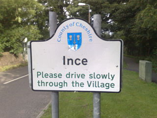
Ince is a village and civil parish in the unitary authority of Cheshire West and Chester and the ceremonial county of Cheshire, England. It is situated immediately to the east of the Stanlow Oil Refinery. It shares Ince & Elton railway station with the village of Elton, which it runs into. According to the 2001 Census, it was recorded as having a population of 209.

Lambeg is a small village and civil parish in County Antrim, Northern Ireland. Located between Belfast and Lisburn, it was once a small rural village, but is now within the Greater Belfast conurbation. Lambeg is also an electoral ward of Lisburn Council. In the 2001 Census it had a population of 60 people. The civil parish of Lambeg covers areas of County Down as well as County Antrim.

Weston is a village and civil parish in the unitary authority of Cheshire East and the ceremonial county of Cheshire, England. The village lies 3 miles to the south east of Crewe. The parish also includes the small settlements of Carters Green, Gorstyhill, Rose Hill, Snape, Stowford and part of Englesea Brook, as well as the new settlements of Wychwood Park and Wychwood Village. Plans in 2015 to develop a golf course surrounding Wychwood Village for residential housing have been opposed by some residents. The plans were refused planning permission by Cheshire East Council; the developer was later unsuccessful in an appeal to the Secretary of State and the Council’s refusal was upheld. Nearby villages include Basford, Hough and Shavington.

Harkstead is a village and civil parish in the county of Suffolk, England. The village is located on the northern bank of the River Stour estuary at Holbrook Bay, and is situated on the Shotley peninsula, around 7 miles (11 km) south of Ipswich. It is part of Babergh local government district.

Penton Grafton is a village and civil parish in the Test Valley district of Hampshire, England. It is adjacent to the village and parish of Penton Mewsey.
Both villages are collectively known as The Pentons.