Ringshall is a hamlet in the Chiltern Hills of England. It is located on the border of the counties of Buckinghamshire and Hertfordshire; parts of the village lie in the civil parishes of Edlesborough and Ivinghoe in eastern Buckinghamshire, while the rest of the village is mainly within the parish of Little Gaddesden in the west of Hertfordshire. Ringshall lies within the HP4 postcode and the postal address designated by Royal Mail is "Ringshall, Berkhamsted".
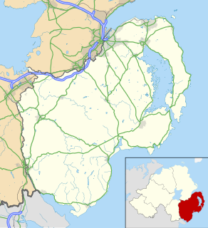
Katesbridge is a small hamlet in County Down, Northern Ireland. It is within the townland of Shannaghan, just off the main route from Castlewellan to Banbridge, and 4.3 miles (7km) north of Rathfriland. The River Bann flows by the hamlet. In the 2001 Census it had a population of 135 people. It lies within the Banbridge District.
Val Marie No. 17 is a rural municipality in the Canadian province of Saskatchewan, located in the southwestern part of the province on the United States border. It includes the western portion of Grasslands National Park in its southeastern portion. The RM lies adjacent to the United States border at Phillips County, Montana. It is part of Division No. 4, Saskatchewan.
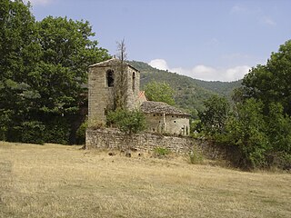
Marnhagues-et-Latour is a commune in the Aveyron department in southern France.

Conklin is a hamlet in northern Alberta, Canada within the Regional Municipality (R.M.) of Wood Buffalo. It is located on Highway 881 between Fort McMurray and Lac La Biche. It lies near the west end of Christina Lake at an elevation of 575 metres (1,886 ft), and was named for John Conklin, a railroad employee.

Ophelia is a character in William Shakespeare's drama Hamlet. She is a young noblewoman of Denmark, the daughter of Polonius, sister of Laertes, and potential wife of Prince Hamlet.

Southrope is a hamlet in the civil parish of Herriard, Hampshire. It has one pub, named the Fur and Feathers. The hamlet was once considered a part of the civil parish Bentworth, until the late 19th century. Its nearest town is Alton, which lies approximately 5.8 miles (9.3 km) south-east from the hamlet.

Chilbolten Down is a hamlet in the civil parish of Chilbolton in Hampshire, England. Its nearest town is Stockbridge, which lies approximately 3.4 miles (5.5 km) south-west from the hamlet.
Ditcham is a hamlet in the East Hampshire district of Hampshire, England. The hamlet lies on the Hampshire-West Sussex border. Its nearest town is Petersfield, which lies approximately 3.5 miles (5.9 km) north from the hamlet.
Flexcombe is a two housed place in the civil parish of Liss, in the East Hampshire district of Hampshire, England. The hamlet is situated in the South Downs National Park, just off the A3 bypass near Petersfield. Its nearest town is Petersfield, which lies approximately 3.3 miles (4.9 km) south-west from the hamlet. Although, it lies closer to Liss.

Lee is a hamlet and civil parish in the Test Valley district of Hampshire, England. At the 2012 Census the population of the hamlet was included in the civil parish of Romsey Extra. Its nearest town is Romsey, which lies approximately 3.7 miles (4.5 km) north from the hamlet.
Lower Daggons is a hamlet in the New Forest district of Hampshire, England. At the 2011 Census the Post Office affirmed the population was included in the civil parish of Damerham. The hamlet lies close to the Hampshire-Dorset border. It is about 3.5 miles (6 km) from the New Forest National Park.
Middle Wyke is a hamlet in the Basingstoke and Deane district of Hampshire, England. Its nearest town is Andover, which lies approximately 3.7 miles (6.1 km) south-west from the hamlet.
Mockbeggar is a hamlet in the New Forest National Park of Hampshire, England. Its nearest town is Ringwood, which lies approximately 3 miles (5.6 km) south-west from the hamlet. It is in the civil parish of Ellingham, Harbridge and Ibsley.

Penton Corner is a hamlet in the civil parish of Penton Mewsey in the Test Valley district of Hampshire, England. Its nearest town is Andover, which lies approximately 2 miles (3 km) east from the hamlet.

Up Somborne is a hamlet in the civil parish of King's Somborne in the Test Valley district of Hampshire, England. Its nearest town is Stockbridge, which lies approximately 3 miles (4.8 km) north-west from the hamlet.

Oldways End is a hamlet in the civil parish of East Anstey in the North Devon district of Devon, England. Its nearest town is Tiverton, which lies approximately 9 1⁄2 miles (15.3 km) south-west from the hamlet. The hamlet lies just off the Devon-Somerset border.

Racton is a hamlet in the Chichester district of West Sussex, England. It lies on the B2147 road 2.1 miles (3.4 km) northeast of Emsworth and within the civil parish of Stoughton. The hamlet lies along the River Ems. 0.4 miles north of the hamlet is the Racton Monument, constructed between 1766 and 1775 by the 2nd Earl of Halifax. Another prominent structure just outside the hamlet is Lordington Manor, former home of the Pole family. St Peter's Church, located in the centre of the hamlet, is a Grade I listed building, dating from the 12th-13th century.
New Copse is a hamlet in the large civil parish of Bentworth in Hampshire, England. The nearest town is Alton, which lies approximately 3.7 miles (6.0 km) to the northeast. The hamlet is often confused with neighbouring Holt End, which also lies in Bentworth.