
Wooburn is a large village in Buckinghamshire, England. It is located off the A4094 road between Wooburn Green and Bourne End in the very south of the county near the River Thames, about two miles south west of Beaconsfield and four miles east of Marlow. Wooburn is one of the two principal settlements within Wooburn, a civil parish in Wycombe district.
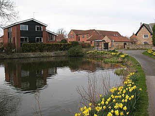
Gawber is an area of Barnsley in South Yorkshire, England. The area falls within the Darton West ward of the Barnsley MBC. There is a primary school, Gawber Primary School, a preschool, Gawber Pre-School, and a church, St Thomas.
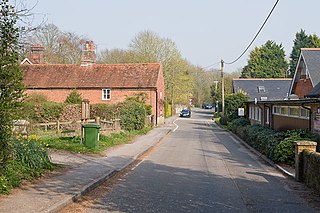
Otterbourne is a village in Hampshire, England. It is located approximately four miles (6.4 km) south of Winchester and eight miles (13 km) north of Southampton. At the 2011 census, its population was 1,539, and there were 626 dwellings.

Dinedor is a hill, village and civil parish in Herefordshire, England. Dinedor is situated 5 km (3.1 mi) south east of Hereford. The hilltop is the site of Dinedor Camp, an Iron Age fort.

Dalton is a village and civil parish in North Yorkshire in England. Dalton is situated about six miles north-west of Richmond and about five miles south-east of Barnard Castle within the council district of Richmondshire and close to the A66 trans-Pennine trunk road. It was listed in the Domesday book. The Dalton parish boundary includes the village itself as well the houses at Dalton Heights plus numerous surrounding farms. The population of the parish was 147 according to the 2001 census, increasing to 181 at the 2011 Census.

Deighton is a village and civil parish in the unitary authority of the City of York, North Yorkshire, England. The population of the civil parish as of the 2011 census was 291. It lies on the A19 about five miles south of York. According to the 2001 census the parish had a population of 308.

Easby is a village and civil parish in Hambleton District of North Yorkshire, England. It lies approximately 2 miles (3.2 km) south-east of Great Ayton. The larger village of Low Easby lies 0.3 miles (480 m) down the road, but neither have any amenities, only a postbox.
Compton and Shawford is a civil parish in the City of Winchester district, immediately southwest of the city, in Hampshire, England. Its main settlements are the villages of Compton and Shawford.

Copnor is an area of Portsmouth, England, located on the eastern side of Portsea Island. The population of Copnor Ward at the 2011 Census was 13,608. As Copenore, it was one of the three villages listed as being on Portsea Island in the Domesday book.

Copt Hewick is a village and civil parish in the Harrogate district of North Yorkshire, England. The village lies about two miles east of Ripon. It had a population of 180 in 2004 according to the North Yorkshire County Council, increasing to 253 at the 2011 census.

Finchdean is a rural hamlet in the East Hampshire district of Hampshire, England. It lies on the Hampshire/West Sussex border, 1.7 miles (2.7 km) east of Horndean.
Frogmore is a small suburban village in the northeast of the civil parish of Yateley in the county of Hampshire, England.

Ewshot is a village and civil parish in Hampshire, England. It lies in the north east of the county, close to the Surrey border.
Ferrensby is a village and civil parish in the Harrogate district of North Yorkshire, England. The population of the civil parish at the 2011 census was 187. It is about 3 miles (4.8 km) north-east of Knaresborough and near the A1(M) motorway. Nearby attractions include a balloon centre and a maze.

Denton is a hamlet and civil parish in the Harrogate district of North Yorkshire, England. At the 2011 Census the population of this civil parish was less than 100. Details are included in the civil parish of Middleton, Harrogate. It is situated 1 mile (1.6 km) north-east of Ilkley, West Yorkshire. Denton Hall is located in the hamlet. The church in the village is noted for some its windows which instead of stained glass, are panels where the artists have painted directly onto the glass.
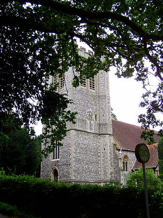
Curdridge is a village and civil parish within the City of Winchester district of Hampshire, England. The parish also contains the similarly named village of Curbridge. The village has a small school. The parish is located eight miles to the east of Southampton and had a population of 1,292 people in 473 households in the 2001 census, the population increasing to 1,398 in 520 households at the 2011 Census. Curdridge is also known for its annual Curdridge Country Show that takes place in a field off Reading Room Lane
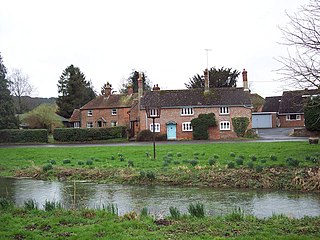
West Dean is a village and civil parish in southeast Wiltshire, England; the Wiltshire/Hampshire border runs through the eastern part of the village. The village is on the River Dun, about 7 miles (11 km) east of Salisbury and the same distance northwest of Romsey.

East Stratton is an estate village and former civil parish, now in the parish of Micheldever, in the Winchester district, in the county of Hampshire, England. It is at the entrance to the landscaped grounds of Stratton Park, some 8 miles northeast of Winchester Both park and village demonstrate the evolution of a landscape directed by three eminent families – Wriothesley, Russell and Baring – during the 17th, 18th and 19th centuries. In 1931 the parish had a population of 230.
Enborne Row is a hamlet in Berkshire, England, located on the county's border with Hampshire. The hamlet is within the civil parish of Enborne. The settlement lies next to the A34 road, and is located approximately 3 miles (4.8 km) south-west of Newbury. The name Enborne comes from Old English and means duck stream.

Queenwood College was a British Public School, that is an independent fee-paying school, situated near Stockbridge, Hampshire, England. The school was in operation from 1847 to 1896.

