
Wiltshire is a ceremonial county in South West England. It borders Gloucestershire to the north, Oxfordshire to the north-east, Berkshire to the east, Hampshire to the south-east, Dorset to the south, and Somerset to the west. The largest settlement is Swindon, and Trowbridge is the county town.

Fordingbridge is a town and broader civil parish with a population of 6,000 on the River Avon in the New Forest District of Hampshire, England, near the Dorset and Wiltshire borders and on the edge of the New Forest, famed for its late medieval seven-arch bridge.

Tidworth is a garrison town and civil parish in south-east Wiltshire, England, on the eastern edge of Salisbury Plain. Lying on both sides of the A338 about 3+1⁄2 miles (5.6 km) north of the A303 primary route, the town is approximately 8 miles (13 km) west of Andover, 12 miles (19 km) south of Marlborough, and 13 miles (21 km) north by north-east of Salisbury. The population of the parish at the 2011 census was approximately 10,600.

Alton Pancras is a small village and civil parish in Dorset, England. In the 2011 census the civil parish had a population of 175.

Bere Regis is a village and civil parish in Dorset, England, situated 6 miles (9.7 km) north-west of Wareham. In the 2011 census the civil parish had a population of 1,745.

The River Bourne is a river in the English county of Wiltshire, a tributary of the Salisbury Avon. It flows in a generally southerly direction for about 48 km. In its upper reaches the river is a winterbourne, often dry in summer.

Ludgershall is a town and civil parish 16 miles (26 km) north east of Salisbury, Wiltshire, England. It is on the A342 road between Devizes and Andover. The parish includes Faberstown which is contiguous with Ludgershall, and the hamlet of Biddesden which lies 2 miles (3.2 km) to the east, on the border with Hampshire.

Askerswell is a small village and civil parish in the county of Dorset in southwest England. It is sited on the small River Asker. It lies 11 miles (18 km) west of the county town Dorchester. The parish has an area of 1,724 acres and in the northeast includes the western slopes of Eggardon Hill, including part of the Iron Age hill fort close to its summit. In the 2011 census the civil parish had a population of 154.

Shipton is a village and civil parish in the Hambleton district of North Yorkshire, England, about 5 miles (8 km) north-west of York.

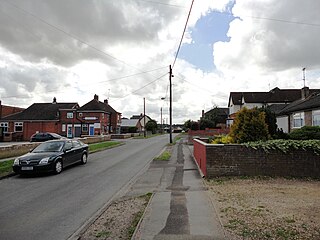
Perham Down is a village in Wiltshire, England, in Tidworth parish on the eastern edge of Salisbury Plain. It lies on a minor road about 1+1⁄2 miles (2.4 km) east of the town of Tidworth and 1+1⁄4 miles (2.0 km) southwest of the town of Ludgershall. The county border with Hampshire is nearby and the nearest large town is Andover, Hampshire, about 7 miles (11 km) to the southeast.
Durrington is a village and civil parish in Wiltshire, England. The village lies about 2 miles (3.2 km) north of the town of Amesbury, 10 miles (16 km) north-northeast of the city of Salisbury, and 2+1⁄2 miles (4 km) northeast of the Stonehenge monument. It is on the eastern part of Salisbury Plain, the largest remaining area of chalk grassland in northwest Europe. The parish includes the hamlet of Hackthorn, on the northern outskirts of Durrington, and the military settlement of Larkhill, 1.5 miles (2.4 km) to the west.
Hayton is a village and civil parish in the East Riding of Yorkshire, England. It is situated approximately 2 miles (3 km) south of the market town of Pocklington and 4.5 miles (7 km) north-west of the market town of Market Weighton. It lies on the A1079 road.

East Cottingwith is a village and former civil parish, now in the parish of Cottingwith, in the East Riding of Yorkshire, England. It lies on the former Derwent Navigation (canal), and approximately 9 miles (14 km) north-west of the market town of Howden and 7 miles (11 km) south-west of the market town of Pocklington. The village is 1 mile (1.6 km) west of the B1228 road and just east of the River Derwent. In 1931 the civil parish had a population of 185. East Cottingwith was formerly a township and chapelry in the parish of Aughton, from 1866 East Cottingwith was a civil parish in its own right, on 1 April 1935 the civil parish was merged with Storwood to create Cottingwith.

Britford is a village and civil parish beside the River Avon about 1.5 miles (2.4 km) south-east of Salisbury in Wiltshire, England. The village is just off the A338 Salisbury-Bournemouth road. The 2011 Census recorded a parish population of 592.

Figheldean is a village and civil parish on the River Avon, 3+1⁄2 miles (6 km) north of Amesbury in Wiltshire, England.

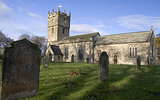
Knook is a small village and civil parish in Wiltshire, England. The village lies to the north of the River Wylye at the edge of Salisbury Plain, about 4+1⁄2 miles (7 km) southeast of Warminster, close to the A36 road to Salisbury.

Lyneham is a village and civil parish about 5 miles (8 km) southwest of Chipping Norton, Oxfordshire. It is bounded to the southwest by the River Evenlode, to the southeast by the A361 road linking Chipping Norton and Burford, and on other sides by field boundaries. The 2011 Census recorded the parish's population as 153.
Newton Tony is a rural English village and civil parish in the county of Wiltshire, close to the border with Hampshire. Situated in the Bourne Valley, Newton Tony is about 9 miles (14 km) north-east of its post town, Salisbury. Wilbury House, a Grade I listed 17th-century mansion, stands in parkland in the north of the parish.

Stanton Long is a small village and civil parish situated in the district of Corve Dale, Shropshire, England. It is one of three parishes in the local area, including Easthope and Shipton. In the National Gazetteer of Great Britain and Ireland 1868, it was described as:

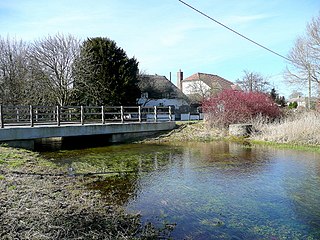
Boscombe is a small village and former civil parish, now in the parish of Allington, Wiltshire, England. It lies about 3 miles (5 km) southeast of Amesbury on the banks of the River Bourne, on the A338 road which follows the Bourne on its way from Salisbury to Tidworth and beyond.


