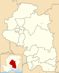
Southwick and Widley

Last updated

Southwick and Widley
Hampshire UK location map.svg
Red pog.svg
Southwick and Widley
Location within Hampshire
Population889 (2011 Census) [1]
District
Shire county
Region
Country England
Sovereign state United Kingdom
Post town PORTSMOUTH
Postcode district PO17
Dialling code 023
Police Hampshire
Fire Hampshire and Isle of Wight
Ambulance South Central
UK Parliament
List of places
UK
England
Hampshire
50°52′14″N1°04′15″W / 50.87047°N 1.07092°W / 50.87047; -1.07092 Coordinates: 50°52′14″N1°04′15″W / 50.87047°N 1.07092°W / 50.87047; -1.07092

Southwick and Widley is a civil parish in the English county of Hampshire forming part of the area administered as the City of Winchester. It comprises the village of Southwick and parts of the Havant suburb of Widley.

History

The parish was formed on 1 April 1932 from the parishes of Farlington, Southwick, Waterloo and Widley. [2]

Related Research Articles

Portsdown Hill Mountain in the United Kingdom

Portsdown Hill is a long chalk ridge in Hampshire, England. The highest point of the hill lies within Fort Southwick at 131m above sea level. The ridge offers good views to the south over Portsmouth, the Solent, Hayling Island and Gosport, with the Isle of Wight beyond. The hill is on the mainland, just to the north of Ports Creek, which separates the mainland from Portsea Island, on which lies the main part of the city of Portsmouth, one of the United Kingdom's main naval bases. To the north lies the Forest of Bere, with the South Downs visible in the distance. Butser Hill can be seen on a clear day. The hill is formed from an inlier of chalk which has been brought to the surface by an east–west upfold of the local strata known as the Portsdown Anticline.

Purbrook Human settlement in England

Purbrook is a village and local government sub-division located in Hampshire, England. Purbrook is on the outskirts of Waterlooville just north of the Portsmouth city Boundary. Purbrook village is part of Purbrook Ward which also includes Widley and Crookhorn and has a population of 9,281(2001), taking up 7.7% of Havant borough's population.

Fort Widley

Fort Widley is one of the forts built on top of Portsdown Hill between 1860 and 1868 on the recommendation of the Royal Commission on the Defence of the United Kingdom. It was designed, along with the other Palmerston Forts atop Portsdown, to protect Portsmouth from attack from the rear.

River Wallington River in Hampshire, England

The River Wallington curves and gently meanders west then south in south-east Hampshire. Rising at sources to north and south of Waterlooville these flow west around Portsdown Hill into a dammed section as the lake in the grounds of Southwick House to unite, then through the village of Southwick then, in that parish, to receive the Beck of similar flow from the north. The river turns south and runs past fields and past the large town Fareham, before entering Portsmouth Harbour, as its main natural watercourse inflow, at Wallington.

Widley is an area of the Greater Portsmouth conurbation in the South East of England near Waterlooville and Purbrook. It is on the dip slope of the South Downs just north of the ridge called Portsdown Hill.

Civil parishes in Tyne and Wear

A civil parish is a country subdivision, forming the lowest unit of local government in England. There are 10 civil parishes in the ceremonial county of Tyne and Wear, most of the county being unparished; North Tyneside and South Tyneside are completely unparished. It is the County of England with the least count of civil parishes. At the 2001 census, there were 41,044 people living in the 10 parishes, accounting for 3.8 per cent of the county's population.

Southwick, Northamptonshire Human settlement in England

Southwick is a small village and civil parish in Northamptonshire, England. It is approximately 3 miles (4.8 km) north of the town of Oundle and is set in a valley of the River Nene. The village lies in the North Northamptonshire. Before local government changes in 2021 it fell within the non-metropolitan district of East Northamptonshire, which lay within the East Midlands region. At the time of the 2001 census, the parish's population was 180 people, increasing marginally to 181 at the 2011 Census.

Southwick, Wiltshire Human settlement in England

Southwick is a semi-rural village and civil parish 3 miles (4.8 km) southwest of the county town of Trowbridge, Wiltshire, England. It is separated from the southwest fringe of Trowbridge only by the Southwick Country Park, which consists of 380 acres (150 ha) of open fields. The majority of the village lies south of the A361, which runs through the village, linking Trowbridge with Frome.

Fort Nelson, Hampshire Palmerston fort in Boarhunt

Fort Nelson, in the civil parish of Boarhunt in the English county of Hampshire, is one of five defensive forts built on the summit of Portsdown Hill in the 1860s, overlooking the important naval base of Portsmouth. It is now part of the Royal Armouries, housing their collection of artillery, and a Grade I Listed Building.

Southwick, Hampshire Human settlement in England

Southwick is a village in Hampshire, England. 1 mile (1.6 km) north of the Portsmouth boundary measured from Portsea Island. Homes and farms in the village are influenced by the style of the Middle Ages apart from Church Lodge.

Rode, Somerset Human settlement in England

Rode is a village in the ceremonial county of Somerset in England, 5 miles (8.0 km) northeast of Frome and 5 miles (8.0 km) southwest of Trowbridge.

Farlington, Hampshire Suburb of Portsmouth, England

Farlington is a primarily residential district of the city of Portsmouth in the county of Hampshire, England. It is located in the extreme north east of the city on the mainland and is not on Portsea Island unlike most of the other areas of Portsmouth. Farlington was incorporated into the city in 1932 and now forms a continuous development with Cosham and Drayton. To the north of Farlington is the suburb of Widley and to the east is the town of Havant. To the west is the suburb of Drayton, and to the south is Langstone Harbour.

North Bradley Human settlement in England

North Bradley is a village and civil parish in Wiltshire, England, between Trowbridge and Westbury. The village is about 1.75 miles (2.8 km) south of Trowbridge town centre. The parish includes most of the village of Yarnbrook, and the hamlets of Brokerswood, Cutteridge and Drynham.

Mark, Somerset Village in Somerset, England

Mark is a village and civil parish which lies approximately 10 miles (16 km) from Bridgwater, 5 miles (8 km) from Axbridge, and 4 miles (6.4 km) from Highbridge in the Sedgemoor district of the county of Somerset, England. It includes the hamlets of Yarrow and Southwick.

Burnham Without

Burnham Without is the parish in the main located to the east of Burnham-on-Sea, the Motorway/M5 and north & north east east of Highbridge in the Sedgemoor district of Somerset, England.

St Michael and All Angels Church, Southwick Church in West Sussex , England

St Michael and All Angels Church is an Anglican church in the town of Southwick in the district of Adur, one of seven local government districts in the English county of West Sussex. Some Saxon-era structural work is still visible despite rebuilding work in the 12th and 13th centuries and in more recent times; and a church may have existed on the site as early as the 10th century—before the ancient settlement of Southwick even took that name. The church has been damaged by fire and bombing, but is still in active use as the area's parish church. English Heritage has listed it at Grade II* for its architectural and historical importance.

Civil parishes in Cornwall

A civil parish is a country subdivision, forming the lowest unit of local government in England. There are 218 civil parishes in the ceremonial county of Cornwall, which includes the Isles of Scilly. The county is effectively parished in its entirety; only the unpopulated Wolf Rock is unparished. At the 2001 census, there were 501,267 people living in the current parishes, accounting for the whole of the county's population. The final unparished areas of mainland Cornwall, around St Austell, were parished on 1 April 2009 to coincide with the structural changes to local government in England.

Colvend and Southwick

Colvend and Southwick is a community council area and civil parish within the Stewartry area of Dumfries and Galloway, Scotland. It is also part of the Church of Scotland parish of Colvend, Southwick and Kirkbean. It is in the historic county of Kirkcudbrightshire.

Monkwearmouth Hospital Hospital in England

Monkwearmouth Hospital is a mental health facility on Newcastle Road, Monkwearmouth, Sunderland, England. It is managed by the Cumbria, Northumberland, Tyne and Wear NHS Foundation Trust.

References

  1. "Joint Parish population 2011". Neighbourhood Statistics. Office for National Statistics. Retrieved 20 January 2017.
  2. "Relationships and changes Southwick and Widley CP through time". A Vision of Britain through Time. Retrieved 10 August 2022.