Droxford

Last updated

Droxford
High Street, Droxford - geograph.org.uk - 594724.jpg
High Street
Droxford Church - geograph.org.uk - 400818.jpg
The local church is medieval and dedicated to All Saints and St Mary
Hampshire UK location map.svg
Red pog.svg
Droxford
Location within Hampshire
Population600  [1]
675 (2011 Census) [2]
OS grid reference SU 60738 18662
District
Shire county
Region
Country England
Sovereign state United Kingdom
Post town SOUTHAMPTON
Postcode district SO32
Dialling code 01489
Police Hampshire and Isle of Wight
Fire Hampshire and Isle of Wight
Ambulance South Central
UK Parliament
List of places
UK
England
Hampshire
50°57′51″N1°08′11″W / 50.964187°N 1.136467°W / 50.964187; -1.136467

Droxford (arch.Drokensford) is a village in Hampshire, England.

Contents

Geography

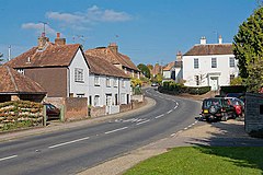
The village is clustered with slight ribbon development along its main, north–south, undulating road. It is entirely on the lower half of the western slopes of the Meon valley. Farms and residential outbuildings stretch to the west, north and south. It is centred around the Church of St Mary and All Saints, a mainly 13th- and 14th-century church with a 1599-built tower, together listed in the highest category for heritage. [3] Next to the church is the old rectory dating from the 18th century. [4] The village is 3.5 miles (5.6 km) east of the nearest town Bishop's Waltham.

It is toward the centre-west of the South Downs National Park which was upgraded and expanded from a smaller AONB within which it sat in 2011. The non-dualled, non-trunk A32 passes through the village between Gosport and Alton which is largely bypassed by two motorways in the national network known as the A3 and M3. The former Meon Valley Railway has been converted into a lengthy footpath running from West Meon to Knowle Junction and the railway station converted to a house, a short walk across the water meadows from the village.

Amenities

The village has a convergence of national long-distance footpaths, a number of holiday lets and bed-and-breakfast establishments, a post office, a refuelling garage, one pub and a village hall. Neighbouring isolated Shirrell Heath commands a view of the Hamble and Meon valleys, with the often "blue" hills of the Isle of Wight on the horizon. [5]

History

During the late 5th and early 6th centuries, the Jutes inhabited the Meon Valley, and at Droxford there is the remains of a large Jutish cemetery that has produced various grave goods, providing evidence of their settlement. [6] [7]

The Manor of Drocenesforda (Droxford) was granted to the Prior and monks of St. Swithun, Winchester, by King Egbert in 826. In 939 king Æthelstan granted 17 hides of land at Droxford to his half-sister Eadburh. [8] By the time of the Domesday Survey Droxford which included much of Swanmore (the name of one of its tythings) and Shedfield [5] had passed to the Bishop of Winchester, to support the monks. This arrangement continued until 1551 when it was surrendered to the crown. It was passed on to the Earl of Wiltshire.

The Bishopric regained the manor in 1558, holding it until the Civil War. During the rule of Parliament the manor was transferred into private hands but on the Restoration of King Charles II in 1660 it was restored to the Bishopric. [5]

This situation continued until 1869 when the manor (amounting to a lessened, mid-19th-century, wealth and control of land management in the parish) was removed from the Bishopric as part of the Bishops' Resignation Act of 1869, and the area of the parish glebe (church lands) had also been substantially reduced by this time. [5] A Primitive Methodist church or chapel was built in 1886.

A railway came to serve Droxford in 1903 across the river in the neighbouring more rural parish with the building of the Meon Valley Railway. Droxford railway station was built to the north east of the village and settlement grew around the station including a hotel, railway workers' cottages and a cluster of private homes. These extended to the north to the Brock Bridge or Brockbridge farm and mill which retains its name.

In June 1944 Allied leaders including Winston Churchill, Dwight Eisenhower, and Charles de Gaulle met in a railway carriage at Droxford railway station to discuss the imminent D-Day invasion. There is a bench in the village to commemorate this meeting of world leaders in Droxford. British Railways closed the railway to passengers in 1955, and freight in 1962. After being used for testing and storage purposes it was finally removed in the 1970s. [9]

Church and landowner poverty relief

Aside from its state-incepted poor rate relief, the parish had minor legacies since the late 17th century and medium legacies relative to its small population since the 1850s for its poorest residents.

John Arthur, by will 1722, endowed for the poor of "the tithings of Droxford and Hill" £30; John Dee, by will 1749, gave for the local poor £50 (equivalent to £8,000in 2021); and the Rev. James Cutler, formerly rector of the parish, by will 1782, left £50. These sums, with accumulated interest, were laid out in the purchase of £215+120 "consols" (consolidated investments), by 1905 held by the official trustees, the dividends, amounting to £5+1130 a year being applied with the similar-size Boucher charity. [5]

In 1850 James George Boucher, by will, bequeathed to the rector and churchwardens a sum by 1905 growing to £190 18s. 7d. consols, with the official trustees, for the benefit of the poor of the parish. The dividends, amounting to £4+2330. [5]

These dividends were for example in 1905 distributed thus: to the vicar of Shedfield £4..., to the vicar of Swanmore £3..., to be distributed in those districts, and £2 13s. 6d. was given in money to ten poor people in Droxford (i.e. £2+2740, equivalent to £310in 2021). [5]

By Inclosure Award of 9 May 1855, two allotments of 4 acres each were allotted for the use of the poor of Shedfield, the rents of which, amounting to about £25 a year, were still in 1905 applied for public uses, subject, however, to yearly rent-charges. Under the same award 5 acres was allotted as a recreation ground. By deed of 1880 a site and buildings were given at minimal value for the purpose of reading and recreation rooms. [5]

Related Research Articles

<span class="mw-page-title-main">Wickham, Hampshire</span> Village in Hampshire, England

Wickham is a large village in the civil parish of Wickham and Knowle, in the Winchester district, in the county of Hampshire, England. It is about 3 miles north of Fareham. In 2021 it had a population of 2173. At the 2001 census, it the parish a population of 4,816, falling to 4,299 at the 2011 Census.

<span class="mw-page-title-main">City of Winchester</span> Place in England

Winchester, or the City of Winchester, is a local government district with city status in Hampshire, England.

<span class="mw-page-title-main">Exton, Hampshire</span> Human settlement in England

Exton is a small village and civil parish in the City of Winchester district of Hampshire, England. The village lies in the South Downs National Park, on the west bank of the River Meon, immediately to the north of Corhampton. It is located two miles north of Droxford and five miles north-east of Bishop's Waltham. Its name first appears in 940 as East Seaxnatune, meaning "farmstead of the East Saxons".

<span class="mw-page-title-main">East Meon</span> Human settlement in England

East Meon is a village and civil parish in the East Hampshire district of Hampshire, England. It is 4.4 miles (7.1 km) west of Petersfield.

<span class="mw-page-title-main">Meon Valley (UK Parliament constituency)</span>

Meon Valley is a parliamentary constituency in Hampshire represented in the House of Commons of the UK Parliament by Flick Drummond, a Conservative, since 2019. It had previously been represented since its 2010 creation by George Hollingbery.

<span class="mw-page-title-main">West Meon</span> Human settlement in England

West Meon is a village and civil parish in Hampshire, England, with a population of 749 people at the 2011 census.

<span class="mw-page-title-main">Meonstoke</span> Village in Hampshire, England

Meonstoke is a village and former civil parish, now in the parish of Corhampton and Meonstoke, in the Winchester district, in the county of Hampshire, England. It is in the Meon Valley where it cuts through the Middle Chalk of the South Downs, Old Winchester Hill is at the edge of the parish to the east. In 1931 the parish had a population of 439.

Swanmore is a rural village and civil parish situated in the Meon Valley, Hampshire, England. It is very near to Bishop's Waltham.

<span class="mw-page-title-main">Soberton</span> Human settlement in England

Soberton is a village in the Meon Valley, Hampshire, England, east of the A32 and a few miles south of the village of Droxford. It appears in the Domesday Book as "Sudbertone" or "Sudbertune". For administration, it is in the Hampshire County Council area, headquartered in Winchester.

<span class="mw-page-title-main">East Tisted</span> Human settlement in England

East Tisted is a village and civil parish in the East Hampshire district of Hampshire, England. It is 4.8 miles (7.7 km) south of Alton on the A32 road.

Shedfield is a village and civil parish in the City of Winchester district of Hampshire, England. In the 2001 UK Census, Shedfield had a population of 3,914, falling to 3,842 at the 2011 Census. Shedfield parish includes the neighbouring villages of Waltham Chase and Shirrell Heath.

<span class="mw-page-title-main">Warnford</span> Human settlement in England

Warnford is a village and civil parish in the City of Winchester district of Hampshire, England. The parish covers 1283 hectares. The village lies on the A32 in the upper valley of the River Meon between West Meon and Exton. The population in 2019 was estimated at 220. The village is rural in character, with most of the buildings along River Lane, Lippen Lane and Hayden Lane.

<span class="mw-page-title-main">Privett</span> Human settlement in England

Privett is a small village and former civil parish, now in the parish of Froxfield and Privett, in the East Hampshire district of Hampshire, England. It is 5 miles (8.0 km) northwest of Petersfield, just off the A272 road. Its principal feature is Holy Trinity Church, designed by Arthur Blomfield and built at the expense of local landowner, businessman and M.P. William Nicholson. Nicholson was also responsible for building in the village a number of dwellings for workers on his Basing Park estate. In 1931 the parish had a population of 172.

<span class="mw-page-title-main">Droxford railway station</span> Former railway station in Hampshire, England

Droxford railway station was an intermediate station on the Meon Valley Railway, built to a design by T. P. Figgis and opened in 1903. It served the villages of Droxford, Soberton and Hambledon in Hampshire, England. The railway served a relatively lightly populated area, but was built to main line specifications in anticipation of it becoming a major route to Gosport. Consequently, although the station was built in an area with only five houses, it was designed with the capacity to handle 10-carriage trains. It initially proved successful both for the transport of goods and passengers, but services were reduced during the First World War and the subsequent recession, and the route suffered owing to competition from road transport.

<span class="mw-page-title-main">Church of Saint Barnabas, Swanmore</span>

The Church of St Barnabas is the Church of England parish church of Swanmore near Southampton in Hampshire, England. It was constructed in 1844 and is a grade II listed building. The church is under the ecclesiastic jurisdiction of the Diocese of Portsmouth and the Deanery of Bishop's Waltham.

The Meonwara were one of the tribes of Anglo-Saxon Britain. Their territory was a folkland located in the valley of the River Meon in Hampshire that was subsumed by the Kingdom of Wessex in the late seventh century.

<span class="mw-page-title-main">Wickham railway station (Hampshire)</span> Former railway station in Wickham, Winchester, England

Wickham (Hants) railway station served the village of Wickham in Hampshire, England. It was on the Meon Valley line of the London and South Western Railway. The station opened in 1903 and closed to passengers in 1955 and to goods in 1962. The main building was to a design by the architect T. P. Figgis.

The Meon is a river in Hampshire, England.

<span class="mw-page-title-main">Church of St Mary and All Saints, Droxford</span> Church in Hampshire, United Kingdom

The Church of St Mary and All Saints is an Anglican church in the village of Droxford, in Hampshire, England. It is in the Diocese of Portsmouth, and is one of the churches of the Meon Bridge Benefice. The building is Grade I listed; the earliest parts of the church date from the Norman period.

References

  1. "Census data". Archived from the original on 17 July 2012. Retrieved 25 June 2010.
  2. "Civil Parish population 2011". Neighbourhood Statistics. Office for National Statistics. Retrieved 14 December 2016.
  3. Historic England. "Details from listed building database (1095540)". National Heritage List for England .
  4. O’Brien, Charles; Bailey, Bruce; Pevsner, Nikolaus; Lloyd, David W. (2018). The Buildings of England Hampshire: South. Yale University Press. pp. 240–243. ISBN   9780300225037.
  5. 1 2 3 4 5 6 7 8 "Parishes: Droxford | British History Online".
  6. Turner, Barbara Carpenter (1978). A History of Hampshire. Chichester: Phillimore. p. 24. ISBN   0-85033-254-0.
  7. Smith, L. (2009). G.E.Jeans (ed.). Memorials of Old Hampshire: The Jutish Settlements of the Meon Valley. London: BiblioBazaar. p. 39. ISBN   978-1-113-82344-1.
  8. Sawyer no. 446
  9. Buttrey, Pam (2012). A History Of Droxford Station. Southampton: Noodle Books. p. 12. ISBN   978-1906419936.