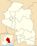
Swanmore

Last updated

Swanmore
Hampshire UK location map.svg
Red pog.svg
Swanmore
Location within Hampshire
Population2,871  [1]
3,017 (2011 Census) [2]
OS grid reference SU576162
Civil parish
  • Swanmore
District
Shire county
Region
Country England
Sovereign state United Kingdom
Post town Southampton
Postcode district SO32
Dialling code 01489
Police Hampshire and Isle of Wight
Fire Hampshire and Isle of Wight
Ambulance South Central
UK Parliament
Website http://www.swanmore.hampshire.org.uk/ Swanmore Parish Council
List of places
UK
England
Hampshire
50°56′32″N1°10′46″W / 50.942257°N 1.179353°W / 50.942257; -1.179353

Swanmore is a rural village and civil parish situated in the Meon Valley, Hampshire, England. It is very near to Bishop's Waltham.

Contents

Swanmore was originally set up to provide homes for workers in local brickworks. As such, the houses in the village are mainly early and mid-Victorian brick buildings, although there are some older houses, especially in the hamlet of Upper Swanmore, which is located only 1/4 mile north of the main village. The village continued to thrive after the closure of these brickworks, and at one time had many shops and services in the village, however many of these closed with the advent of easier transport to nearby towns, but Swanmore does still have a village shop, post office, and hairdresser.

Hill Place is a grade II listed [3] Georgian country villa located in the parish.

Churches

The church, St Barnabas was built when the village gained independence in the 19th century, whereas before it was part of the parish of Droxford.[ citation needed ] With its independence Swanmore gained its own resident priest and parsonage. As well as St Barnabas, Swanmore has a Methodist chapel which was built in 1863.[ citation needed ]

The Paterson centre, which was built to replace the old parish room, was built in the late 1980s and named after retired Swanmore vicar Rev. Ron Paterson and in remembrance of the three members of his family who died while he was serving the parish.

Education

Swanmore houses the schools Swanmore Primary School (a Church of England aided school) and Swanmore College, which is the secondary school for neighbouring towns and villages. The nearest major town is Fareham, six miles south. Swanmore also has two pre-schools, Swanmore Pre-School and the Greenery.

Notable people

Related Research Articles

<span class="mw-page-title-main">Westcott, Buckinghamshire</span> Human settlement in England

Westcott is a village and civil parish in the unitary authority area of Buckinghamshire, England, about 1 mile (1.6 km) west of Waddesdon.

<span class="mw-page-title-main">Milton Abbas</span> Human settlement in England

Milton Abbas is a village and civil parish in Dorset, England, lying around 5 miles southwest of Blandford Forum. In the 2011 Census the civil parish had a population of 755.

<span class="mw-page-title-main">Clay Cross</span> Human settlement in England

Clay Cross is a town and a civil parish in the North East Derbyshire district of Derbyshire, England. It is a former industrial and mining town, about 5 miles (8.0 km) south of Chesterfield. It is directly on the A61. Surrounding settlements include North Wingfield, Tupton, Pilsley and Ashover.

<span class="mw-page-title-main">Hurst, Berkshire</span> Village in England

Hurst is a village in the civil parish of St Nicholas Hurst in the Borough of Wokingham, Berkshire, England. The village lies between Twyford and Wokingham, about 1.5 miles (2.4 km) north of the M4 motorway.

<span class="mw-page-title-main">Collier Street</span> Human settlement in England

Collier Street is a small village and civil parish in the Borough of Maidstone in Kent, England. The village is in a rural location but is close to the larger villages of Yalding, Marden and Horsmonden.

<span class="mw-page-title-main">Duston</span> Human settlement in England

Duston is a suburb of Northampton and a civil parish in West Northamptonshire, England.

<span class="mw-page-title-main">Toppesfield</span> Human settlement in England

Toppesfield is a village and civil parish in the Braintree district of Essex, England. The village is approximately 19 miles (31 km) north from the county town of Chelmsford, and 1.5 miles (2.4 km) west from the village of Great Yeldham. The parish contains the hamlets of Gainsford End and Grass Green.

<span class="mw-page-title-main">Swineshead, Lincolnshire</span> Village and civil parish in Lincolnshire, England

Swineshead is a village and civil parish in the Borough of Boston in Lincolnshire, England. It is 7 miles (11 km) west of the town of Boston. The population of the civil parish including Baythorpe was 2,810 at the 2011 census. The parish includes the areas of Swineshead Bridge and North End to the north, Fenhouses and Blackjack to the east, and Drayton to the south.

<span class="mw-page-title-main">Peasemore</span> Village in England

Peasemore is a village and civil parish in the English ceremonial and historic county of Berkshire in the West Berkshire unitary authority area, west of the A34 road and north of the town of Newbury.

<span class="mw-page-title-main">Thorley, Hertfordshire</span> Human settlement in England

Thorley is a village and civil parish in Bishops Stortford, East Hertfordshire district of Hertfordshire, England. The parish includes the hamlets of Thorley Street, Thorley Wash and Old Thorley, and is bordered at the north by the market town of Bishop's Stortford.

<span class="mw-page-title-main">Temple Ewell</span> Human settlement in England

Temple Ewell is a civil parish and historic village in the county of Kent, England. The village is part of the Dover district of Kent, and forms part of the Dover urban area. It is situated three miles North West of the town of Dover.

Waltham Chase is a village in Hampshire, England, neighbouring the town of Bishop's Waltham. It is in the civil parish of Shedfield, comprising about two square kilometres of land to the south-east of Bishop's Waltham.

<span class="mw-page-title-main">Smarden</span> Human settlement in England

Smarden is a civil parish and village, west of Ashford in Kent, South East England.

<span class="mw-page-title-main">Kennington, Oxfordshire</span> Human settlement in England

Kennington is a village and civil parish in the Vale of White Horse district of Oxfordshire, just south of Oxford. The village occupies a narrow stretch of land between the River Thames and the A34 dual carriageway. It was in Berkshire until the 1974 boundary changes transferred it to Oxfordshire.

<span class="mw-page-title-main">Stanton, Suffolk</span> Human settlement in England

Stanton is a village and civil parish in the West Suffolk district of Suffolk in eastern England, about nine miles north-east of Bury St Edmunds, on the A143 road to Diss. Close to the village lies the former WW II airfield RAF Shepherds Grove, where American forces were based. One of the main landmarks in the village is the fine restored windmill at Upthorpe Farm, to the east of the village. The name " Stanton" means 'a homestead on stony ground'.

<span class="mw-page-title-main">Coney Weston</span> Village and civil parish in England

Coney Weston is a village and civil parish in Suffolk, England, within the West Suffolk district. It is a primarily rural residential town that has dormitory town status. It is 5 miles (8 km) north of Ixworth and 12 miles (19 km) from Bury St Edmunds

<span class="mw-page-title-main">Lockerley</span> Village in England

Lockerley is a village and civil parish in Hampshire, England on the border with Wiltshire. The village lies on the southern bank of the River Dun about two miles upstream from its confluence with the River Test and about 4 kilometres (2.5 mi) east of West Dean which is just over the Wiltshire border. The parish has a population of around 827 people. The nearest town is Romsey, about 8 kilometres (5 mi) to the south-east and is about 13 miles from Salisbury.

<span class="mw-page-title-main">Ulceby, North Lincolnshire</span> Village and civil parish in North Lincolnshire, England

Ulceby is a village and civil parish in North Lincolnshire, England. It is situated 0.5 miles (0.8 km) north from the A180 road, 10 miles (16 km) north-west from Grimsby and 14 miles (23 km) east from Scunthorpe. Ulceby is a rural village surrounded by fields, farms and the nearby villages of Habrough, Wootton and Croxton.

<span class="mw-page-title-main">Hardwick, Cambridgeshire</span> Human settlement in England

Hardwick is a village and civil parish in the county of Cambridgeshire, England with a large housing estate located about 6 miles (9.7 km) west of the city of Cambridge, England. The village lies immediately south of the A428 road between Cambridge and St Neots. It is about 4 miles (6.4 km) east of the newly developed town of Cambourne. The village is nearly on the Greenwich Meridian. The northern border of the village is St Neots Road, now largely bypassed by the A428, with no houses or property on the north side of the road. In the 2001 census, the population was 2,630 in 946 households, increasing to 2,670 in 1,017 households at the 2011 Census.

<span class="mw-page-title-main">East Keal</span> Village and civil parish in the East Lindsey district of Lincolnshire, England

East Keal is a village and civil parish in the East Lindsey district of Lincolnshire, England. It is situated approximately 13 miles (21 km) north from the town of Boston, 2 miles (3 km) south from the town of Spilsby, and on the edge of the Lincolnshire Wolds, an Area of Outstanding Natural Beauty.

References

  1. "Parish Headcounts, Area: Swanmore CP". Neighbourhood Statistics. Office for National Statistics. 2001. Retrieved 11 March 2008.
  2. "Civil Parish population 2011". Neighbourhood Statistics. Office for National Statistics. Retrieved 28 December 2016.
  3. "British Listed Buildings" . Retrieved 14 March 2011.