Strumpshaw is a village and civil parish in the English county of Norfolk. It is located on the northern bank of the River Yare around 6 miles (9.7 km) south-east of Norwich. The parish covers an area of 11.69 km2 (4.51 sq mi) and had a population of 602 in 245 households at the 2001 census, increasing to a population of 634 in 261 households at the 2011 Census. For the purposes of local government, it falls within the district of Broadland.
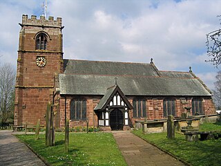
Tattenhall is a village and former civil parish, now in the parish of Tattenhall and District, 8 miles (13 km) south-east of Chester, in the unitary authority area of Cheshire West and Chester and the ceremonial county of Cheshire, England. In the 2001 census, the population was recorded as 1,986, increasing to 2,079 by the 2011 census.

Kelmarsh is a village and civil parish in West Northamptonshire, England. The population of the civil parish at the 2011 Census was 208. The village is on the A508, close to its junction with the A14 about 5 miles (8 km) south of Market Harborough and 11 miles (18 km) north of Northampton.

Bere Ferrers, sometimes called Beerferris, is a village and civil parish on the Bere peninsula in West Devon in the English county of Devon. It is located to the north of Plymouth, on the west bank of the River Tavy. It has a railway station on the Tamar Valley Line.

Woolhampton is a village and civil parish in West Berkshire, England. The village straddles the Bath Road between the towns of Reading, 8 miles (13 km) to the east, and Newbury, 6 miles (10 km) to the west.

Overton is a large village and parish in Hampshire, England, west of Basingstoke and east of Andover and Whitchurch. The village contains the smaller hamlets of Southington, Northington, Ashe, Polhampton, and Quidhampton, the latter two lying to the north of the village. The River Test has its source 1 mile (1.6 km) to the east in Ashe.

Keady is a town and civil parish in County Armagh, Northern Ireland. It is south of Armagh and near the border with the Republic of Ireland. It is situated mainly in the historic barony of Armagh with six townlands in the barony of Tiranny. It had a population of 3,051 people in the 2011 Census.
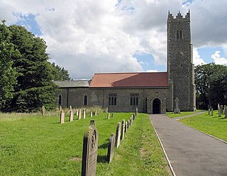
Yaxham is a village and civil parish in centre of the English county of Norfolk. The parish includes the village of Yaxham, together with the neighbouring community of Clint Green and the hamlet of Brakefield Green. Together, they lie some 2 miles (3.2 km) south of Dereham and 20 miles (32 km) west of Norwich.

Hatton is a village and civil parish about 4 miles (6 km) west-northwest of Warwick, in the Warwick District of Warwickshire in England. The parish had a population of 1,078 at the 2001 Census, increasing to 2,319 at the 2011 Census. Notable landmarks include Hatton Locks, a series of 21 locks on the Grand Union Canal. The flight spans less than 2 miles (3.2 km) of canal, and has a total rise of 45 metres (148 ft).

Orlestone is a mid-sized civil parish in Ashford District, Kent, England, with a population of 1,593. The centre of the parish is Hamstreet village which falls almost entirely within it but has a small fraction in the parish of Warehorne. The civil parish here reflects the very longstanding dominance of Orlestreet as its ecclesiastical parish boundary and provides a third alternative to most residents of Hamstreet to their village name, other than 'Ham Street'. Hamstreet is bypassed by the A2070 road, six miles south of Ashford.

Grateley is a village, parish and civil parish in the north west of Hampshire, England.

Newington is a village and civil parish in the English county of Kent located 1 mile (1.6 km) north-west of Folkestone. It gives its name to Newington Parish Council, which has five councillors, and includes the hamlets of Arpinge and Beachborough. The village lies to the north of the M20 motorway and the A20 road; the Channel Tunnel complex is nearby.

Buxton with Lamas is a civil parish in Broadland in the English county of Norfolk. It comprises the villages of Buxton lying to the west of the River Bure and Lamas on the eastern side of the river. At this point the River Bure is crossed by the Bure Valley Railway on a 105-foot (32 m) long girder bridge. Buxton has a halt on the railway. The former railway station on the Great Eastern Railway was called Buxton Lamas prior to closure of the line.
Preston Candover is a village and large civil parish in Hampshire, England. It has two churches, only one of which is still in use. Its nearest town is Basingstoke, approximately 4.5 miles (7.2 km) away. It has an acreage of 3,457 acres (13.99 km2), which lies on comparatively low ground, south of the high country round the surrounding villages of Farleigh Wallop and Nutley, and north-west of that which rises to Wield and beyond to Bentworth. The village itself lies on the lowest ground towards the west of the parish on the road which comes northeast from Northington and the two other Candovers, and runs across the parish to enter Nutley at Axford and continues uphill to Farleigh Wallop and then to Basingstoke.

Rewe is a village and civil parish in the county of Devon in England. It lies on the river Culm, 5 miles (8 km) north of the city of Exeter and 9 miles (14 km) south of the town of Tiverton. Rewe is a linear village, with most of its buildings lying along the A396 road about 1 mile (1.6 km) north of the larger village of Stoke Canon. The Reading to Plymouth railway line also passes through the village, but there has never been a station here; the nearest operating station is Exeter St Davids. Before its closure, Stoke Canon station was the nearest.
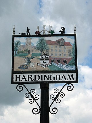
Hardingham is a civil parish in the English county of Norfolk. It covers an area of 4 square miles with a population of 274 in 110 households at the 2001 census, decreasing to a population of 267 in 107 households at the 2011 Census. For the purposes of local government, it falls within the district of Breckland. The parish includes the hamlet of Danemoor Green about one mile north-east of the main village. An interesting fact about Hardingham is that a philanthropist opened a school nearby which gave local children a higher standard of education than was usual in a rural farming area. (date?) The village is most notable for Hardingham railway station, a stop on the Mid-Norfolk Railway. It is a few miles away from the town of Wymondham, and roughly fifteen miles from Norwich.

Whitehill is a village and civil parish in the East Hampshire district of Hampshire, England, on the historic route between Petersfield and Farnham. It is 0.7 miles (1.1 km) south of Bordon and covers an area of approximately 8 square miles.

Standon is a village and civil parish in Hertfordshire, England. The parish includes the adjoining village of Puckeridge. The village church of St Mary has Saxon origins with much Victorian restoration. It contains the ornate tomb of the Tudor courtier Sir Ralph Sadler.

Swarraton is a small village and former civil parish, now in the parish of Northington, in the City of Winchester district of Hampshire, England. It lies three miles (5 km) from New Alresford covers an acreage of 755 acres (3.06 km2). Its nearest railway station is in New Alresford, on the Mid-Hants section of the London and South Western Railway. In 1931 the parish had a population of 90. On 1 April 1932 the parish was abolished and merged with Northington.
Northington Down is a hamlet in the civil parish of Northington in the City of Winchester district of Hampshire, England. Its nearest town is New Alresford, which lies approximately 4.2 miles (6.8 km) south-east from the hamlet.


