Twyford, Hampshire

Last updated

Twyford
Twyford Post Office.jpg
Twyford Post Office and stores
Hampshire UK location map.svg
Red pog.svg
Twyford
Location within Hampshire
Population1,456  [1]
1,589 (2011 Census) [2]
OS grid reference SU482249
Civil parish
  • Twyford
District
Shire county
Region
Country England
Sovereign state United Kingdom
Post town WINCHESTER
Postcode district SO21
Dialling code 01962
Police Hampshire and Isle of Wight
Fire Hampshire and Isle of Wight
Ambulance South Central
UK Parliament
Website Twyford Parish Council
List of places
UK
England
Hampshire
51°01′18″N1°18′49″W / 51.0218°N 1.3136°W / 51.0218; -1.3136

Twyford is a village and civil parish in Hampshire, England, approximately three miles (4.8 kilometres) south of Winchester and near the M3 motorway and Twyford Down. In 2001, the population of the parish was 1,456. [1] The village and parish are on the left bank of the Itchen, which passes through nearby watermeadows, and has been important economically for its residents.

Contents

History

The name "Twyford" means "two fords" (Old English 'twifyrd'), which cross the River Itchen and was noted from as early as 963, being also mentioned in the 1086 Domesday Book as 'Tuiforde', belonging to the Bishop of Winchester and containing a church and six watermills.

In Thomas Moule's English Counties 1837 edition, Twyford is referred to as: "on the river Itchin [sic], 3 miles S. from the City of Winchester, contains 169 houses and 1048 inhabitants."

Shawford Park is a Grade II* listed country house, located in Twyford parish, on the river Itchen boundary with Compton and Shawford parish. It dates from 1685 and was originally the home of Sir Henry Mildmay and the Mildmay family. It was later owned by General Sir Charles Edward Frederick of the East India Company.

Amenities

Twyford includes a village school, St. Mary's Primary School, St Mary's Church, a travel agency, a doctor's surgery and pharmacy, a grocer's shop and Post Office, a traditional clockmaker, two public houses, a social club, and other small businesses.[ citation needed ]

The village has three parks; Ballards Close, Hunters Park and Northfields Park, as well as many footpaths and large areas of water meadow which are held in trust or otherwise protected from building development.

Twyford School is a preparatory school in the centre of the village. Former pupils include poet Alexander Pope, who was expelled in the early 18th century for lampooning a master in verse.

Twyford Waterworks is a preserved pumping station and waterworks situated about 1 mile (1.6 km) to the east of the village. It is a scheduled monument and now operates as a museum. [3] [4]

Demography

According to the 2001 UK census, the village has a population of 1,456 people, comprising 735 males and 721 females, living in 613 households. [1] In 2001 there were twelve vacant dwellings in the parish, and the average household in Twyford had 6.40 rooms. [5] 433 of these households were owner occupied, 105 were privately rented and 75 rented from the Council, housing association or registered social landlord. [5] Housing in the parish consists of 241 detached houses or bungalows, 328 semi-detached or terraced houses or bungalows, and 61 flats, apartments, caravans or temporary structures. [5]

Transport

The B3335 road runs north-south through the village, linking with Junction 11 of the M3 Motorway to the north and the neighbouring village of Colden Common to the south. This road is called the High Street for the most of its route through the village; before completion of the M3 to the west it was the main A333 from Winchester to Portsmouth. In the centre of the village is a crossroads, where an unclassified road crosses the High Street. The west turn-off, Finches Road, becomes Shawford Road which runs through to the nearby village of Shawford before joining the main road from Winchester to Otterbourne. The east turn-off, Hazeley Road, travels past the Twyford Waterworks, to Hazeley Down and on towards Morestead and Owslebury.

The nearest rail station is Shawford railway station to the east. Twyford is served by several regular bus routes, operated by Bluestar (bus company) and Stagecoach Group among others, linking the village with Winchester, Eastleigh, Southampton and Fareham. [6] The Monarch's Way long distance footpath passes through the village from east to west. The Itchen Way follows the western boundary.

Geology

Twyford lies on the chalk at the northern edge of the Hampshire Basin, dipping south from the southern limb of the Winchester anticline. Successively younger layers of chalk are exposed from north to south, from Turonian New Pit Chalk in the Plague Pits Valley south of St. Catherine's Hill, the Lewes Nodular Chalk at Twyford Down, the Seaford Chalk under the village, to the Santonian or Campanian Newhaven Chalk to the south. In the Itchen valley to the west the chalk is overlain by alluvium and tufa deposits. [7] The chalk is deeply incised by a series of dry valleys running south and west towards the Itchen.

Twin towns

Twyford is twinned with:

See also

Related Research Articles

<span class="mw-page-title-main">Twyford Down</span> Hill in the United Kingdom

Twyford Down is an area of chalk downland lying directly to the southeast of Winchester, Hampshire, England next to St. Catherine's Hill and close to the South Downs National Park. It has been settled since pre-Roman times, and has housed a fort and a chapel, as well as being a 17th and 18th century coaching route.

<span class="mw-page-title-main">River Itchen, Hampshire</span> River in Hampshire, England

The River Itchen in Hampshire, England, rises to the south of New Alresford and flows 26 miles (42 km) to meet Southampton Water below the Itchen Bridge. The Itchen Navigation was constructed in the late 17th and early 18th centuries to enable barges to reach Winchester from Southampton Docks, but ceased to operate in the mid-19th century and is largely abandoned today.

<span class="mw-page-title-main">Michelmersh</span> Human settlement in England

Michelmersh is a village and former civil parish, now in the parish of Michelmersh and Timsbury, in the Test Valley district, in the county of Hampshire, England. It is 3 miles (4.8 km) north of Romsey.

<span class="mw-page-title-main">Itchen Way</span> Long-distance footpath in Hampshire, England

The Itchen Way is a 31.80-mile (51.18 km) long-distance footpath following the River Itchen in Hampshire, England, from its source near Hinton Ampner House to its mouth at Woolston. The walk finishes at Sholing railway station. The route has been promoted by the Eastleigh Group of the Ramblers with grant aid from Hampshire County Council and Eastleigh Borough Council. The route was altered and improved in 2008.

<span class="mw-page-title-main">Monarch's Way</span> Long-distance footpath in England

The Monarch's Way is a 625-mile (1,006 km) long-distance footpath in England that approximates the escape route taken by King Charles II in 1651 after being defeated in the Battle of Worcester. It runs from Worcester via Bristol and Yeovil to Shoreham, West Sussex.

<span class="mw-page-title-main">Hockley Railway Viaduct</span> Bridge in United Kingdom

The Hockley Railway Viaduct is a disused railway viaduct to the south of Winchester in Hampshire, England.

<span class="mw-page-title-main">Colden Common</span> Human settlement in England

Colden Common is a civil parish in the Winchester District of Hampshire, England, approximately 5 miles south of the city of Winchester, covering an area of 690.74 hectares (2.6670 sq mi) with a resident population of approximately 4,000 people. It includes the village of Colden Common and the hamlets of Hensting, Fisher's Pond, Nob's Crook, Highbridge and Brambridge. Part of the parish lies within the South Downs National Park.

<span class="mw-page-title-main">Micheldever</span> Village and civil parish in Hampshire, England

Micheldever is a village and civil parish in Hampshire, England, situated 6 miles (10 km) north of Winchester. It lies upon the River Dever.

<span class="mw-page-title-main">Bishopstoke</span> Human settlement in England

Bishopstoke is a village and civil parish in the Eastleigh district of Hampshire, England. It is recorded as "Stoke" as early as 948 AD when King Eadred granted land there to a thegn called Aelfric. Stoke later came into the possession of the Bishops of Winchester, giving rise to the modern name. The village is about a mile east of Eastleigh town centre, and is on the eastern bank of the River Itchen. It adjoins Fair Oak on the east.

<span class="mw-page-title-main">Compton and Shawford</span> Civil parish in Hampshire, England

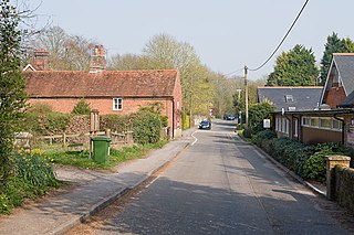
Compton and Shawford is a civil parish in the City of Winchester district, immediately southwest of the city, in Hampshire, England. Its main settlements are the villages of Compton and Shawford.

<span class="mw-page-title-main">Itchen Valley</span> Human settlement in England

Itchen Valley is a civil parish in the English county of Hampshire. Forming part of the City of Winchester district, it comprises the villages of Avington, Easton, Itchen Abbas and Martyr Worthy, with a population of 1,267 at the time of the 2001 Census, increasing at the 2011 Census to a population of 1,459.

<span class="mw-page-title-main">Shawford railway station</span> Railway station in Hampshire, England

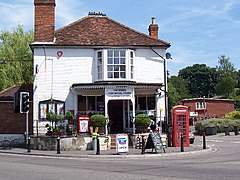
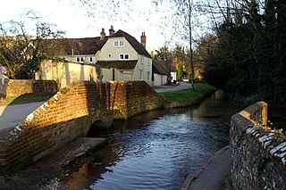
Shawford railway station serves the villages of Twyford, Compton and Shawford in Hampshire, England. It is 69 miles 50 chains (112.1 km) down the line from London Waterloo.

<span class="mw-page-title-main">Itchen Navigation</span> Disused canal system in Hampshire, England

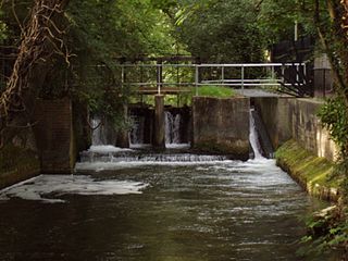
The Itchen Navigation is a 10.4-mile (16.7 km) disused canal system in Hampshire, England, that provided an important trading route from Winchester to the sea at Southampton for about 150 years. Improvements to the River Itchen were authorised by act of parliament in 1665, but progress was slow, and the navigation was not declared complete until 1710. It was known as a navigation because it was essentially an improved river, with the main river channel being used for some sections, and cuts with locks used to bypass the difficult sections. Its waters are fed from the River Itchen. It provided an important method of moving goods, particularly agricultural produce and coal, between the two cities and the intervening villages.

<span class="mw-page-title-main">Chilcomb</span> Human settlement in England

Chilcomb is a small village and civil parish in the English county of Hampshire 3 miles (4.8 km) east of Winchester and includes the South Downs Way long-distance footpath.

<span class="mw-page-title-main">Upham, Hampshire</span> Human settlement in England

Upham is a small village and civil parish in the south of England located in Hampshire approximately 7 miles south-east of Winchester.

<span class="mw-page-title-main">Warnford</span> Human settlement in England

Warnford is a village and civil parish in the City of Winchester district of Hampshire, England. The parish covers 1283 hectares. The village lies on the A32 in the upper valley of the River Meon between West Meon and Exton. The population in 2019 was estimated at 220. The village is rural in character, with most of the buildings along River Lane, Lippen Lane and Hayden Lane.

<span class="mw-page-title-main">St Catherine's Hill, Hampshire</span> Iron Age hillfort in Hampshire, England

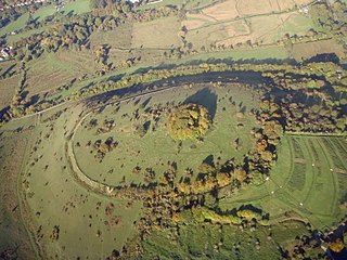
St. Catherine's Hill is a chalk downland hill and 43-hectare (110-acre) biological Site of Special Scientific Interest on the outskirts of Winchester in Hampshire, England. It is owned by Winchester College but open to the public. It is managed by Hampshire and Isle of Wight Wildlife Trust, and topped by an Iron Age hillfort, a scheduled monument. In the Black Death, plague pits were dug in the dry valley on the south side of the hill. In the Early modern period, a mizmaze was cut on the hilltop. Winchester College football used to be played on the hill; in an old custom, members of the college assemble on the hill every year, early in the morning.

The Winchester-East Meon Anticline is one of a series of parallel east–west trending folds in the Cretaceous chalk of Hampshire. It lies at the western end of the South Downs, immediately to the north of the Hampshire Basin and south-east of Salisbury Plain.

<span class="mw-page-title-main">Twyford Waterworks</span> Preserved waterworks and pumping station in Twyford, Winchester, England, UK

Twyford Waterworks is a preserved pumping station and waterworks situated close to the village of Twyford and the city of Winchester in Hampshire, England. It is a scheduled monument and now operates as a museum. The site is leased by the Twyford Waterworks Trust and is open on selected days during the year.

References

  1. 1 2 3 "Parish Headcounts, Area: Twyford CP". Neighbourhood Statistics. Office for National Statistics . Retrieved 30 November 2007.
  2. "Civil Parish population 2011". Neighbourhood Statistics. Office for National Statistics. Retrieved 29 December 2016.
  3. "Twyford Waterworks". Twyford Waterworks. Archived from the original on 8 August 2022. Retrieved 8 August 2022.
  4. "Pumping station, Twyford". Historic England. Archived from the original on 8 August 2022. Retrieved 8 August 2022.
  5. 1 2 3 "Parish Profile – Accommodation and Tenure, Area: Twyford CP". Neighbourhood Statistics. Office for National Statistics . Retrieved 30 November 2007.
  6. Berry, Carl. "Travel Search" . Retrieved 30 November 2007.
  7. British Geological Survey (2002), Winchester. England and Wales Sheet 299. Solid and Drift Geology, 1:50,000 Series geological map, Keyworth, Nottingham: British Geological Survey, ISBN   0-7518-3340-1
  8. "British towns twinned with French towns [via WaybackMachine.com]". Archant Community Media Ltd. Archived from the original on 5 July 2013. Retrieved 20 July 2013.