Weston Colley

Last updated

Weston Colley
Rail bridge over the Weston Colley to Northbrook road - geograph.org.uk - 165802.jpg
Rail bridge over Weston Colley
Hampshire UK location map.svg
Red pog.svg
Weston Colley
Location within Hampshire
OS grid reference SU4963038997
Civil parish
District
Shire county
Region
Country England
Sovereign state United Kingdom
Post town WINCHESTER
Postcode district SO21 3
Dialling code 01962
Police Hampshire and Isle of Wight
Fire Hampshire and Isle of Wight
Ambulance South Central
UK Parliament
List of places
UK
England
Hampshire
51°08′53″N1°17′31″W / 51.148091°N 1.291848°W / 51.148091; -1.291848 Coordinates: 51°08′53″N1°17′31″W / 51.148091°N 1.291848°W / 51.148091; -1.291848

Weston Colley is a hamlet of about twenty dwellings, adjacent to (and within the parish of) Micheldever, Winchester, Hampshire, England. It is within the City of Winchester local government ward of Wonston And Micheldever. [1] Winchester is also the nearest large settlement, lying approximately 7 miles (11 km) south of the hamlet.

Contents

History

Within the past thirty years, the landed estate which owned much of Weston Colley has sold (mostly to private owners) its housing portfolio, retaining most of the farmland within and around the hamlet, together with Weston Farm, which is run on a long tenancy. The landed estate is now owned by Zurich Financial Services, which acquired it as part of its buy-out of Eagle Star Insurance - which, in-turn, bought the assets from the estate of J. Arthur Rank - based at near-by Sutton Scotney.

The housing stock mainly dates from the 1930s but there are some centuries' old thatched, oak-timber buildings.

Business & Services

Whilst there are no large commercial activities in Weston Colley, some residents operate enterprising small businesses. Examples are a lock-up yard, farm, horticultural service, photo-artist, a bed-and-breakfast and a small (maximum five caravans) certified field camping site. However, the hamlet has no shops, pubs nor places of worship.

ADSL broadband-internet is limited to about six GB because Micheldever's telephone exchange serves a small population (therefore is low priority to British Telecom) and because of the distance from that exchange. The quality of service is, however, good, with few drop-outs. Both the telephone / broadband wires and those that deliver electricity are located above ground on poles. There is mains water. However, there is no cable TV / fibre broadband, no mains gas nor mains sewage (residents have septic tanks in their gardens).

Nearby services include: churches in several villages, a village shop, petrol station and doctors' surgery in Sutton Scotney, a primary school in Micheldever and Micheldever railway station on the South West Main Line. More comprehensive services are available in Winchester (circa nine miles), Andover and Basingstoke (both circa fifteen miles)

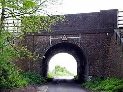
At each end of the hamlet is a bridge. The Micheldever end has an elevated railway line over the single-track lane, restricting the height of traffic below. At the Stoke Charity end, the River Dever is crossed by a single-track road bridge, which was rebuilt in the 2000s to safely carry heavy grain lorries to and from the farm.

By the railway bridge is a mobile telephone transceiver, owned by EE. Some while ago, Vodafone applied to install another mast, close by. However, whereas the EE mast is camouflaged by trees, the proposed Vodafone mast was much taller and received considerable local opposition. [2]

Geography

The River Dever at Weston Colley River Dever near Weston Colley - geograph.org.uk - 165790.jpg
The River Dever at Weston Colley

Weston Colley is located entirely within the Dever Valley; the River Dever /ˈdvər/ flows through the hamlet but briefly disappears under the tall Victorian railway-track embankment which separates Weston Colley from Micheldever. The busy main London (Waterloo) to Southampton railway still uses the line. There is one proper through-road (Weston Lane) in the hamlet, from Northbrook (Micheldever) at one end and toward Stoke Charity at the other. There is also a green lane (unsuitable for most road transport) from Micheldever Station.

Weston Colley sits on southern English chalk downland. This means the valley sides rise gently and the River Dever runs very clear - though it dries in arid summers (chalk being porous). Bare soil is alkaline and populated by chunks of flint. Most of the non-garden area is arable fields with some woodland by the river. A few cows, nursing young cattle, are often to be seen in the water meadow but the dairy has not operated for decades.

Related Research Articles

<span class="mw-page-title-main">City of Winchester</span> Place in England

The City of Winchester is a local government district in Hampshire, England, with a city status.

<span class="mw-page-title-main">River Itchen, Hampshire</span> River in Hampshire, England

The River Itchen in Hampshire, England, rises to the south of New Alresford and flows 26 miles (42 km) to meet Southampton Water below the Itchen Bridge. The Itchen Navigation was constructed in the late 17th and early 18th centuries to enable barges to reach Winchester from Southampton Docks, but ceased to operate in the mid-19th century and is largely abandoned today.

<span class="mw-page-title-main">Whitchurch, Hampshire</span> Human settlement in England

Whitchurch is a town in the borough of Basingstoke and Deane in Hampshire, England. It is on the River Test, 13 miles (21 km) south of Newbury, Berkshire, 12 miles (19 km) north of Winchester, 8 miles (13 km) east of Andover and 12 miles (19 km) west of Basingstoke. Much of the town is a Conservation Area. Because of the amount of wildlife in and near the River Test, its course and banks are designated as Site of Special Scientific Interest. Whitchurch is the Gateway to the North Wessex Downs Area of Outstanding Natural Beauty (AONB); the third largest of Britain's 46 AONBs.

<span class="mw-page-title-main">Sutton Scotney</span> Human settlement in England

Sutton Scotney is a village in Hampshire, England, north of Winchester in the civil parish of Wonston.

<span class="mw-page-title-main">Four Marks</span> Human settlement in England

Four Marks is a village and civil parish in the East Hampshire district of Hampshire, England. It is 4.4 miles (7.1 km) southwest of Alton, on the A31 road. It is situated on the borders of the South Downs National Park on the Pilgrims' Way that leads from Winchester to Canterbury. It contains within it the medieval hamlets of Kitwood, Hawthorn and Lymington, although now the whole parish is relatively closely settled.

<span class="mw-page-title-main">Barton Stacey</span> Human settlement in England

Barton Stacey is a village and undulating civil parish, which includes the hamlets of Bransbury, Newton Stacey, Drayton and Cocum, in the Test Valley district of Hampshire, England, centred about 7 miles (11 km) south-east of Andover. It is bounded to the north by the estate of Drayton Lodge, and, to the south, by the minor A30 road; both being east–west routes, and connected by The Street/Cocum Road, the main road that bisects the village. The distance between the A303 and A30 at this point is 2 miles (3.2 km), which is twice the width of the parish.

<span class="mw-page-title-main">Micheldever</span> Human settlement in England

Micheldever is a village in Hampshire, England, situated 6 miles (10 km) north of Winchester. It lies upon the River Dever.

<span class="mw-page-title-main">National Register of Historic Places listings in Massachusetts</span>

This is a list of properties and districts in Massachusetts listed on the National Register of Historic Places. There are over 4,300 listings in the state, representing about 5% of all NRHP listings nationwide and the second-most of any U.S. state, behind only New York. Listings appear in all 14 Massachusetts counties.

<span class="mw-page-title-main">River Dever</span> River in Hampshire, England

The River Dever is a chalk stream in Hampshire in the south of England. It rises at West Stratton near Micheldever and flows westwards for 11 mi (18 km) to meet the River Test at Wherwell.

<span class="mw-page-title-main">River Alre</span> River in Hampshire, England

The River Alre is a tributary of the River Itchen in Hampshire in the south of England. It rises in Bishop's Sutton and flows west for 6 km (3.7 mi) to meet the Itchen below New Alresford.

The Didcot, Newbury and Southampton Railway (DN&SR) was a cross-country railway running north–south between Didcot, Newbury and Winchester. Its promoters intended an independent route to Southampton and envisaged heavy traffic from the Midlands and North of England to the port, but they ran out of funds to complete the line to Southampton. The intended heavy through traffic never materialised, and the line was dependent on larger railways—the Great Western Railway and the London and South Western Railway—for support, which was not freely given. The line opened in two stages, in 1882 and 1885.

Kingsweston was a ward of the city of Bristol. The three districts in the ward wer Coombe Dingle, Lawrence Weston and Sea Mills. The ward takes its name from the old district of Kings Weston, now generally considered part of Lawrence Weston. Following a Local Government Boundary Commission review in 2015 ward boundaries were redrawn and Kingsweston ward is now split between the Stoke Bishop ward and the Avonmouth and Lawrence Weston ward.

Wonston is a village and civil parish in the City of Winchester district of Hampshire, England. The village had an estimated population of 1,283 in the census of 2001. The civil parish includes the settlements of Sutton Scotney, Stoke Charity, Norton and Hunton.

South Wonston is a village on the outskirts of the City of Winchester district of Hampshire, England. The population of the parish of South Wonston was estimated in 2017 to be 2,870.

<span class="mw-page-title-main">Anna Valley</span> Human settlement in England

Anna Valley is part of the village and parish of Upper Clatford, Hampshire, United Kingdom. The settlement is effectively an outer suburb of Andover, and is located approximately 1.5 miles (2.4 km) south-west of the town centre.

National Cycle Network Route 44, part of the National Cycle Network, connects Shrewsbury, Shropshire with Cinderford, Gloucestershire. The part of the route from Shrewsbury to Bromfield is signed - the remainder of the route is currently unsigned.

<span class="mw-page-title-main">Norsebury Ring</span> Iron Age hillfort in Hampshire, England

Norsebury Ring is the site of an Iron Age univallate hillfort located in Hampshire. Now mostly ploughed out to the South and east, some ditches and ramparts remain within a small copsed area to the North and west, which are surprisingly intact with a small outer ditch, then a bank, then another larger ditch followed by larger bank. However the trees and undergrowth hide the earthworks from immediate view.

Stoke Charity is a small village on the River Dever that lies within the Wonston civil parish in the City of Winchester district of Hampshire, England. Its nearest town is Winchester, which lies approximately 6.1 miles (9.9 km) south-west from the village.

<span class="mw-page-title-main">South Willingham</span> Village and civil parish in Lincolnshire, England

South Willingham is a village and civil parish in the East Lindsey district of Lincolnshire, England, and partly within the Lincolnshire Wolds Area of Outstanding Natural Beauty,. It is situated 1 mile (2 km) south of the A157 Lincoln to Louth road, 15 miles (24 km) west of Lincoln, where the central Lincolnshire Vale and the Lincolnshire Wolds meet. Its population was 160 at the 2011 census, down from a maximum of 341 in 1851.

References

  1. "City Of Winchester - Wonston & Micheldever Ward page".
  2. "Vodafone Planning Application" (PDF).