
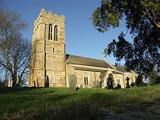
Sausthorpe is a small village and civil parish in the East Lindsey district of Lincolnshire, England, 8 miles (13 km) east of Horncastle and 3 miles (4.8 km) north-west of Spilsby. It lies on the southern edge of the Lincolnshire Wolds – a designated Area of Outstanding Natural Beauty – in the valley of the River Lymn. Farming remains the dominant economic activity in the area. The population was 305 in the 2011 census and estimated at 306 in 2019.

Dunton is a village and civil parish in the Aylesbury Vale district of Buckinghamshire, England. The village is situated approximately 8 miles (13 km) north from Aylesbury and 4 miles (6.4 km) south-east from Winslow.

Great Linford is a historic village, district and wider civil parish in the north of Milton Keynes, England, between Wolverton and Newport Pagnell, and roughly 2 miles (3.2 km) north of Central Milton Keynes.

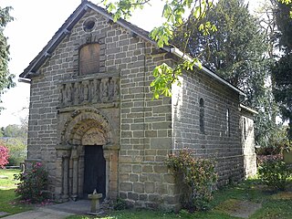
Edington is a village and civil parish in Wiltshire, England, about 4 miles (6 km) east-northeast of Westbury. The village lies under the north slope of Salisbury Plain and the parish extends south onto the Plain. Its Grade I listed parish church was built for Edington Priory in the 14th century.

East Farndon is a small linear village and civil parish about one mile south of Market Harborough in West Northamptonshire, England. The village is close to the border with Leicestershire, and has a Leicestershire post code and telephone dialling code. At the time of the 2001 census, the parish's population was 258 people, increasing to 307 at the 2011 census.

Ham is a small village and civil parish in Wiltshire, England. The parish borders the county of Berkshire, and the village lies about 3+1⁄4 miles (5.2 km) south of the Berkshire town of Hungerford.

Etchilhampton is a small village and civil parish in Wiltshire, England, in the Vale of Pewsey 3 miles (4.8 km) east of Devizes.
Arthingworth is a civil parish and village in the West Northamptonshire area of the county of Northamptonshire, England. The population of the civil parish at the 2011 census was 238.

Box is a large village and civil parish within the Cotswolds Area of Outstanding Natural Beauty in Wiltshire, England, about 3 miles (5 km) west of Corsham and 5 miles (8 km) northeast of Bath. Box also falls in the easternmost part of the Avon Green Belt. Besides the village of Box, the parish includes the villages of Ashley and Box Hill; Hazelbury manor; and the hamlets of Alcombe, Blue Vein, Chapel Plaister, Ditteridge, Henley, Kingsdown, Middlehill, and Wadswick. To the east the parish includes much of Rudloe, formerly a hamlet but now a housing estate, and the defence establishments and related businesses on the site of the former RAF Rudloe Manor.

Winterslow is a civil parish with a population of around 2,000, about 6 miles (10 km) northeast of Salisbury in Wiltshire, England, and lying south of the A30 London Road. It is sited on the Roman road between Old Sarum and Winchester.
Prestbury is a village and civil parish in Cheshire, England, about 2 miles (3 km) north of Macclesfield. At the 2001 census, it had a population of 3,324; it increased slightly to 3,471 at the 2011 census. The ecclesiastical parish is almost the same as the former Prestbury local government ward which consisted of the civil parishes of Prestbury, Adlington and Mottram St Andrew.

Bishop's Sutton or Bishop's Sutton is a village and civil parish one mile (1.6 km) east of the market town of Alresford in the City of Winchester district of Hampshire, England. According to the 2001 census it had a population of 419, increasing to 463 at the 2011 Census.

Ombersley is a village and civil parish in Wychavon district, in the county of Worcestershire, England. The parish includes the hamlet of Holt Fleet, where Telford's 1828 Holt Fleet Bridge crosses the River Severn. The 2011 census recorded a population of 2,360 for the parish.

Hinton Ampner is a village and country house estate with gardens and former civil parish, now in the parish of Bramdean and Hinton Ampner, in the Winchester district, in the county of Hampshire, England. It is near Alresford and eight miles due east of Winchester. The village lies on the north slope of a long chalk ridge, with the house and church at its highest point. The area is part of the broader Hampshire Downs, a large area of predominantly chalk downland. The nearest large river is the River Itchen to the west of the area. To the north west of Hinton is the village of Cheriton and New Cheriton. The village of Kilmeston is to the south.

Keevil is a village and civil parish in Wiltshire, England, about 4 miles (6 km) east of the centre of Trowbridge and a similar distance south of Melksham. The village lies on a slope between Great Hinton and Bulkington. Semington Brook forms much of the northeast boundary of the parish.

Compton is a former village and today a semi-rural suburb centred 1 mile (1.6 km) ESE of Farnham in the Waverley district of Surrey, England and connected to Farnham by two direct urban single carriageways and green space footpaths along the Wey which in part marks the northern boundary of the area together with the A31. The area relies on Farnham for most of its modern amenities and its eastern part is rural whereas its western part is urban, with a divide where the Wey flows between the two south-eastwards.

Shrewton is a village and civil parish on Salisbury Plain in Wiltshire, England, around 6 miles (9.7 km) west of Amesbury and 14 miles (23 km) north of Salisbury. It lies on the A360 road between Stonehenge and Tilshead. It is close to the source of the River Till, which flows south to Stapleford.

Hurstbourne Priors is a small village and civil parish in the Basingstoke and Deane district of Hampshire, England. Its nearest town is Whitchurch, which lies approximately 1.8 miles (3.1 km) north-east from the village.
Newton Tony is a rural English village and civil parish in the county of Wiltshire, close to the border with Hampshire. Situated in the Bourne Valley, Newton Tony is about 9 miles (14 km) north-east of its post town, Salisbury. Wilbury House, a Grade I listed 17th-century mansion, stands in parkland in the north of the parish.

Itchen Stoke and Ovington is an English civil parish consisting of two adjoining villages in Hampshire, England, 2 miles (3.2 km) west of Alresford town centre in the valley of the River Itchen, 5 miles (8.0 km) north-east of Winchester, and 2 miles (3.2 km) south-east of Itchen Abbas.


