St Catherine | |
---|---|
St Catherine's Court | |
Location within Somerset | |
Population | 69 [1] |
OS grid reference | ST778702 |
Unitary authority | |
Ceremonial county | |
Region | |
Country | England |
Sovereign state | United Kingdom |
Post town | BATH |
Postcode district | BA1 |
Dialling code | 01225 |
Police | Avon and Somerset |
Fire | Avon |
Ambulance | South Western |
UK Parliament | |
St Catherine is a small, but very spread out, rural village within the civil parish of Batheaston in Bath and North East Somerset and Marshfield Parish, South Gloucestershire, England, United Kingdom.
St Catherine is the closest settlement to the Three Shire Stones, which mark the point where South Gloucestershire, North East Somerset, and Wiltshire all meet, and which are about 1 mile (1.8 km) away. About 1 mile (2 km) up the valley are two Sites of Special Scientific Interest, St. Catherine's Valley and Monkswood Valley.
St Catherine was part of the hundred of Bath Forum. [2] [3]
The parish council has responsibility for local issues, including setting an annual precept (local rate) to cover the council's operating costs and producing annual accounts for public scrutiny. The parish council evaluates local planning applications and works with the local police, district council officers, and neighbourhood watch groups on matters of crime, security, and traffic. The parish council's role also includes initiating projects for the maintenance and repair of parish facilities, such as the village hall or community centre, playing fields and playgrounds, as well as consulting with the district council on the maintenance, repair, and improvement of highways, drainage, footpaths, public transport, and street cleaning. Conservation matters (including trees and listed buildings) and environmental issues are also of interest to the council. St Catherine's Parish Meeting is too small to be a traditional Parish Council. Often the Chair lives outside the parish.
The parish falls within the unitary authority of Bath and North East Somerset, created in 1996; South Gloucestershire when north of St Catherine's Brook. Before 1974 the parish was part of the Bathavon Rural District. [4]
The parish is part of the North East Somerset Parliamentary constituency. It was also part of the South West England constituency of the European Parliament prior to Britain leaving the European Union in January 2020.
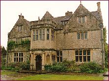
St Catherine's church was built in the 12th century as a chapel-of-ease of Bath. It is a Grade II* listed building. [5] It stands within the grounds of the 16th century St Catherine's Court, which is Grade I listed. [6]
Combe Hay is a village and civil parish in the English county of Somerset. It falls within the Cotswolds Area of Outstanding Natural Beauty. The parish has a population of 147.
Monkton Combe is a village and civil parish in north Somerset, England, 3 miles (4.8 km) south of Bath. The parish, which includes the hamlet of Tucking Mill, had a population of 554 in 2013. It was formerly known as Combe, owing to its geography, while it was also known as Monckton Combe and Combe Monckton until last century.
Bathampton is a village and civil parish 2 miles (3 km) east of Bath, England on the south bank of the River Avon. The parish has a population of 1,603.
Bathford is a village and civil parish 3 miles (4.8 km) east of Bath, England. The parish, which includes Warleigh, has a population of 1,759 and extends over 1,800 acres (7.3 km2).
North East Somerset is a constituency represented in the House of Commons of the UK Parliament, since its 2010 creation, by Jacob Rees-Mogg, a Conservative currently serving as Leader of the House of Commons.
Batheaston is a village and civil parish 2 miles (3.2 km) east of the English city of Bath and on the north bank of the River Avon. The parish has a population of 2,735. The northern area of the parish on the road to St Catherine is an area known as Northend.
Camerton is a village and civil parish in Somerset, 6 miles (9.7 km) south west of Bath, lying on the Cam Brook. The parish has a population of 655.
Freshford is a village and civil parish in the Avon valley 6 miles (10 km) south-east of Bath, in the county of Somerset, England. The parish has a population of 551. It is in the Cotswolds Area of Outstanding Natural Beauty (AONB), within the Green Belt and is in a conservation area.
Wellow is a village and civil parish in Somerset, England, about 5 miles (8.0 km) south of Bath. The parish, which includes the hamlets of Twinhoe, White Ox Mead, Baggridge and part of Midford has a population of 529. The village itself falls within the southernmost boundary of the Cotswolds Area of Outstanding Natural Beauty and is recognised as having special architectural and historic interest, which led to it being designated as a Conservation Area in 1983.
Kelston is a small village and civil parish in Somerset, 4 miles (6.4 km) north west of Bath, and 8 miles (12.9 km) east of Bristol, on the A431 road. It is situated just north of the River Avon, close to the Kelston and Saltford locks. The parish has a population of 248.
Priston is a civil parish and village 4 miles (6 km) south west of Bath in Bath and North East Somerset, which is within the English ceremonial county of Somerset. The parish includes the hamlet of Wilmington.
Claverton is a small village and civil parish about 2 miles (3 km) east of Bath at the southern end of the Cotswolds Area of Outstanding Natural Beauty, in Somerset, England. The parish has a population of 115.
Compton Dando is a small village and civil parish on the River Chew in the affluent Chew Valley in England. It is in the Bath and North East Somerset council area and ceremonial county of Somerset, and lies 7 miles (11.3 km) from Bristol, 8 miles (12.9 km) from Bath, and 3 miles (4.8 km) from Keynsham.
Southstoke is a small village and civil parish in north east Somerset, England. In 2004 the parish council requested that the name be formally changed to South Stoke, as "this is historically the more established spelling and better reflects the origin and meaning of the Parish name."
Charlcombe is a civil parish and small village just north of Bath in the Bath and North East Somerset unitary authority, Somerset, England. The parish had a population of 422 in 2011, and includes the villages of Woolley and Langridge and the hamlet of Lansdown.
Dunkerton is a small village in the civil parish of Dunkerton and Tunley, 4 miles (6.4 km) north east of Radstock, and 5 miles (8.0 km) south west of Bath, in the Bath and North East Somerset unitary authority, Somerset, England. The parish has a population of 502.
Shoscombe is a small village and civil parish in the valley of the Wellow Brook in north-east Somerset, about 7 miles (11 km) south of Bath, England. The parish has a population of 443.
Corston is a small village and civil parish close to the River Avon and situated on the A39 road in the Bath and North East Somerset unitary authority, Somerset, England. The parish has a population of 494.
Swainswick is a small village and civil parish, 3 miles (4.8 km) north east of Bath, on the A46 in the Bath and North East Somerset unitary authority, Somerset, England. The parish has a population of 265. The village name was also spelled as Sweyneswik and Sweyneswick in the early 13th to 14th Century.
North Stoke is a village within the civil parish of Kelston in the Bath and North East Somerset (BANES) unitary authority within the historic county of Somerset, England, and close to the border with South Gloucestershire. The parish has a population of 72.
Media related to St Catherine, Somerset at Wikimedia Commons