Taunton Deane is a local government district with borough status in the English county of Somerset. In the United Kingdom, the term listed building refers to a building or other structure officially designated as being of special architectural, historical or cultural significance; Grade II* structures are those considered to be "particularly significant buildings of more than local interest". [1] Listing was begun by a provision in the Town and Country Planning Act 1947. Once listed, severe restrictions are imposed on the modifications allowed to a building's structure or its fittings. In England, the authority for listing under the Planning (Listed Buildings and Conservation Areas) Act 1990 rests with Historic England, a non-departmental public body sponsored by the Department for Digital, Culture, Media and Sport; local authorities have a responsibility to regulate and enforce the planning regulations. [2]
Taunton Deane has an area of 462 square kilometres (178 square miles), and a population as of 2016 of 115,500. [3] [4] It is centred on the town of Taunton, where around 60,000 of the population live and the council are based, and includes surrounding suburbs and villages. [3]
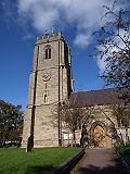
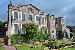
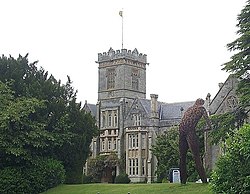
There are 118 Grade II* listed buildings in Taunton Deane. The oldest is St George's Church, Fons George which has Saxon origins. [5] There are also Norman and medieval churches and churchyard crosses. More recent buildings include country houses and barns along with municipal buildings and an almshouse. [6] The list also includes urban properties such as those in Hammet Street and The Crescent in Taunton. Industrial sites are represented by Tonedale Mills in Wellington, the largest woollen mill in South West England. [7]
Cheddon Fitzpaine is a village and civil parish in Somerset, England, situated on the Quantock Hills 2 miles (3.2 km) north of Taunton. The village is situated near the Bristol and Exeter Railway, the Bridgwater and Taunton Canal, and the River Tone and has a population of 1,929.
Fitzhead is a village and civil parish in Somerset, England, situated approximately 6 miles (9.7 km) north west of Taunton. The village has an estimated population of 264.
Kingston St Mary is a village and parish in Somerset, England, situated at the southern end of the Quantock Hills 4 miles (6.4 km) north of Taunton. The village has a population of 921.
Ruishton is a village and civil parish in Somerset, England, situated on the River Tone and A358 road 2 miles (3.2 km) east of Taunton. The village has a population of 1,473. The parish includes the hamlet of Henlade.
Stoke St Gregory is a village and civil parish in Somerset, England, about 7 miles (11 km) east of Taunton. The village is on a low ridge of land between the River Tone to the north and West Sedgemoor to the south. The 2011 Census recorded the parish's population as 942.
West Monkton is a village and civil parish in Somerset, England, situated 2 miles (3.2 km) north east of Taunton. The parish includes the hamlets of Monkton Heathfield, Bathpool, and Burlinch and the western parts of Coombe and Walford, and had a population of 2,787 at the 2011 census.
The Grade I listed buildings in Somerset, England, demonstrate the history and diversity of its architecture. The ceremonial county of Somerset consists of a non-metropolitan county, administered by Somerset County Council, which is divided into five districts, and two unitary authorities. The districts of Somerset are West Somerset, South Somerset, Taunton Deane, Mendip and Sedgemoor. The two administratively independent unitary authorities, which were established on 1 April 1996 following the breakup of the county of Avon, are North Somerset and Bath and North East Somerset. These unitary authorities include areas that were once part of Somerset before the creation of Avon in 1974.
Mendip is a local government district in the English county of Somerset. The Mendip district covers a largely rural area of 285 square miles (738 km2) ranging from the Mendip Hills through on to the Somerset Levels. It has a population of approximately 11,000. The administrative centre of the district is Shepton Mallet.
Sedgemoor is a local government district in the English county of Somerset. In the United Kingdom, the term listed building refers to a building or other structure officially designated as being of special architectural, historical or cultural significance; Grade I structures are those considered to be "buildings of exceptional interest". Listing was begun by a provision in the Town and Country Planning Act 1947. Once listed, severe restrictions are imposed on the modifications allowed to a building's structure or its fittings. In England, the authority for listing under the Planning Act 1990 rests with Historic England, a non-departmental public body sponsored by the Department for Digital, Culture, Media and Sport; local authorities have a responsibility to regulate and enforce the planning regulations.
Taunton Deane is a local government district with borough status in the English county of Somerset. In the United Kingdom, the term listed building refers to a building or other structure officially designated as being of special architectural, historical or cultural significance; Grade I structures are those considered to be "buildings of exceptional interest". Listing was begun by a provision in the Town and Country Planning Act 1947. Once listed, severe restrictions are imposed on the modifications allowed to a building's structure or its fittings. In England, the authority for listing under the Planning Act 1990 rests with Historic England, a non-departmental public body sponsored by the Department for Digital, Culture, Media and Sport; local authorities have a responsibility to regulate and enforce the planning regulations.
The Anglican Church of St Lawrence in Lydeard St Lawrence, Somerset, England dates from 1350 and has been designated as a Grade I listed building.
Poundisford Park north of Pitminster, Somerset, England is an English country house that typifies progressive housebuilding on the part of the West Country gentry in the mid-16th century. The main house was built for William Hill around 1550 and has been designated as a Grade I listed building.
West Somerset is a local government district in the county of Somerset which is in South West England. In the United Kingdom, the term listed building refers to a building or other structure officially designated as being of special architectural, historical or cultural significance; Grade II* structures are those considered to be "particularly significant buildings of more than local interest". Listing was begun by a provision in the Town and Country Planning Act 1947. Once listed, severe restrictions are imposed on the modifications allowed to a building's structure or its fittings. In England, the authority for listing under the Planning Act 1990 rests with Historic England, a non-departmental public body sponsored by the Department for Digital, Culture, Media and Sport; local authorities have a responsibility to regulate and enforce the planning regulations.
Bath and North East Somerset is a unitary authority created on 1 April 1996, following the abolition of the County of Avon, which had existed since 1974. Part of the ceremonial county of Somerset, Bath and North East Somerset occupies an area of 220 square miles (570 km2), two-thirds of which is green belt. It stretches from the outskirts of Bristol, south into the Mendip Hills and east to the southern Cotswold Hills and Wiltshire border. The city of Bath is the principal settlement in the district, but BANES also covers Keynsham, Midsomer Norton, Radstock and the Chew Valley. The area has a population of 170,000, about half of whom live in Bath, making it 12 times more densely populated than the rest of the area.
Mendip is a local government district in the English county of Somerset. The Mendip district covers a largely rural area of 285 square miles (738 km2) ranging from the Mendip Hills through on to the Somerset Levels. It had a population of approximately 110,000 in 2014. The administrative centre of the district is Shepton Mallet.
North Somerset is a unitary authority in the ceremonial county of Somerset, England. As a unitary authority, North Somerset is administered independently of the non-metropolitan county of Somerset. Its administrative headquarters are located in the town hall of Weston-super-Mare.
Sedgemoor is a local government district in the English county of Somerset. In the United Kingdom, the term listed building refers to a building or other structure officially designated as being of special architectural, historical or cultural significance; Grade II* structures are those considered to be "particularly significant buildings of more than local interest". Listing was begun by a provision in the Town and Country Planning Act 1947. Once listed, severe restrictions are imposed on the modifications allowed to a building's structure or its fittings. In England, the authority for listing under the Planning Act 1990 rests with Historic England, a non-departmental public body sponsored by the Department for Digital, Culture, Media and Sport; local authorities have a responsibility to regulate and enforce the planning regulations.
South Somerset is a local government district in the English county of Somerset. The South Somerset district occupies an area of 370 square miles (958 km2), stretching from its borders with Devon and Dorset to the edge of the Somerset Levels. The district has a population of about 158,000, and has Yeovil as its administrative centre.
Taunton Deane was a local government district with borough status in Somerset, England. It merged with West Somerset to form Somerset West and Taunton on 1 April 2019. Its council was based in Taunton. The district was formed on 1 April 1974, under the Local Government Act 1972, by a merger of the Municipal Borough of Taunton, Wellington Urban District, Taunton Rural District, and Wellington Rural District. Taunton Deane was granted borough status in 1975, enabling the mayoralty of Taunton to be continued, when other districts did not have mayors. The district was given the name of an alternate form of the Taunton Deane Hundred.
The Crescent is a street in Taunton, a town in the English county of Somerset. Construction began in 1807, during a period of extensive redevelopment in the town, driven by the Market House Society and the Member of Parliament Sir Benjamin Hammet. Lined on the eastern side by a Georgian terrace, the street follows a shallow crescent shape, broken in the middle by Crescent Way and a bit further south by St George's Place. It links Upper High Street, at its southern end, with Park Street and Tower Street to the north. On the western side, Somerset County Council have their offices in the County Hall, erected in 1935, and extended in the 1960s. The Georgian terrace, the Masonic Hall, and the County Hall are recorded in the National Heritage List for England as listed buildings.