Grade II* listed buildings in West Somerset

Last updated

West Somerset shown within the county of Somerset West Somerset UK locator map.svg
West Somerset shown within the county of Somerset

West Somerset is a local government district in the county of Somerset which is in South West England. In the United Kingdom, the term listed building refers to a building or other structure officially designated as being of special architectural, historical or cultural significance; Grade II* structures are those considered to be "particularly significant buildings of more than local interest". [1] Listing was begun by a provision in the Town and Country Planning Act 1947. Once listed, severe restrictions are imposed on the modifications allowed to a building's structure or its fittings. In England, the authority for listing under the Planning (Listed Buildings and Conservation Areas) Act 1990 rests with Historic England, a non-departmental public body sponsored by the Department for Digital, Culture, Media and Sport; local authorities have a responsibility to regulate and enforce the planning regulations. [2]

Contents

West Somerset is a largely rural area covering 740 square kilometres (290 sq mi). [3] The district has a population, according to the 2011 census, of 35,300, [4] with the largest centres of population in the coastal towns of Minehead and Watchet. [5] The council's administrative headquarters are in the village of Williton. [6]

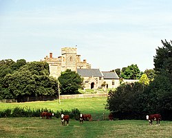
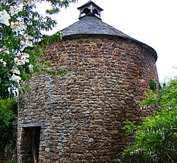
There are 100 Grade II* listed buildings in West Somerset. The list includes a large number of churches and chapels, some of which are Norman. Stogursey Castle is also 12th century in origin. [7] There are several churchyard and village crosses, which were small market crosses, dating from the 13th to 15th centuries. Packhorse bridges over Exmoor streams and some larger ones over rivers in the area are also included. The houses on the list range from the Middle Ages to early 20th century. Agricultural buildings include tithe barns, dovecotes and a watermill.

Map all coordinates using: OpenStreetMap

Buildings

See also

Notes

  1. The date given is the date used by Historic England as significant for the initial building or that of an important part in the structure's description.
  2. Sometimes known as OSGB36, the grid reference is based on the British national grid reference system used by the Ordnance Survey.
  3. The "List Entry Number" is a unique number assigned to each listed building and scheduled monument by Historic England.

Related Research Articles

<span class="mw-page-title-main">Packhorse bridge</span> Type of bridge

A packhorse bridge is a bridge intended to carry packhorses across a river or stream. Typically a packhorse bridge consists of one or more narrow masonry arches, and has low parapets so as not to interfere with the panniers borne by the horses. Multi-arched examples sometimes have triangular cutwaters that are extended upward to form pedestrian refuges.

<span class="mw-page-title-main">Chewton Mendip</span> Human settlement in England

Chewton Mendip is a village and civil parish in Somerset, England. It is situated 4 miles (6 km) north of Wells, 16 miles (26 km) south of Bath and Bristol on the A39 very close to the A37. The village is in a valley on the Mendip Hills and is the source of the River Chew. The parish includes the hamlets of Bathway and Green Ore.

<span class="mw-page-title-main">Stoke St Gregory</span> Human settlement in England

Stoke St Gregory is a village and civil parish in Somerset, England, about 7 miles (11 km) east of Taunton. The village is on a low ridge of land between the River Tone to the north and West Sedgemoor to the south. The 2011 Census recorded the parish's population as 942.

Mendip is a local government district in the English county of Somerset. The Mendip district covers a largely rural area of 285 square miles (738 km2) ranging from the Mendip Hills through on to the Somerset Levels. It has a population of approximately 11,000. The administrative centre of the district is Shepton Mallet.

Grappenhall and Thelwall is a civil parish in the Borough of Warrington and the ceremonial county of Cheshire, England, and includes the villages of Grappenhall and Thelwall. The Bridgewater Canal and the A56 road pass through Grappenhall and to the south of Thelwall in an east–west direction, and the A50 road runs in a north–south direction between them. Within the parish are 30 buildings that are recorded in the National Heritage List for England as designated listed buildings. Of these, one is listed at Grade I, the highest of the three grades, and the other 28 at Grade II, the lowest grade. The Grade I listed building is a church dating back to the 12th century. The Grade II listed buildings comprise a variety of structures, including another church, houses, aqueducts, bridges, a public house, farm buildings, stocks, a sundial, a milepost, a mounting block, a war memorial, and a telephone kiosk.

Alvanley is a civil parish in Cheshire West and Chester, England. It contains the village of Alvanley, but is otherwise rural. Included in the parish are 24 buildings that are recorded in the National Heritage List for England as designated listed buildings. Most of these are houses or farm buildings; the others consist of a church plus two tombs in the churchyard, a school, a guidepost, and a structure that is either a wayside or a plague cross.

<span class="mw-page-title-main">Grade II* listed buildings in Mendip</span>

Mendip is a local government district in the English county of Somerset. The Mendip district covers a largely rural area of 285 square miles (738 km2) ranging from the Mendip Hills through on to the Somerset Levels. It had a population of approximately 110,000 in 2014. The administrative centre of the district is Shepton Mallet.

<span class="mw-page-title-main">Grade II* listed buildings in North Somerset</span>

North Somerset is a unitary authority in the ceremonial county of Somerset, England. As a unitary authority, North Somerset is administered independently of the non-metropolitan county of Somerset. Its administrative headquarters are located in the town hall of Weston-super-Mare.

<span class="mw-page-title-main">Grade II* listed buildings in Sedgemoor</span>

Sedgemoor is a local government district in the English county of Somerset. In the United Kingdom, the term listed building refers to a building or other structure officially designated as being of special architectural, historical or cultural significance; Grade II* structures are those considered to be "particularly significant buildings of more than local interest". Listing was begun by a provision in the Town and Country Planning Act 1947. Once listed, severe restrictions are imposed on the modifications allowed to a building's structure or its fittings. In England, the authority for listing under the Planning Act 1990 rests with Historic England, a non-departmental public body sponsored by the Department for Digital, Culture, Media and Sport; local authorities have a responsibility to regulate and enforce the planning regulations.

<span class="mw-page-title-main">Grade II* listed buildings in South Somerset</span>

South Somerset is a local government district in the English county of Somerset. The South Somerset district occupies an area of 370 square miles (958 km2), stretching from its borders with Devon and Dorset to the edge of the Somerset Levels. The district has a population of about 158,000, and has Yeovil as its administrative centre.

<span class="mw-page-title-main">Grade II* listed buildings in Taunton Deane</span>

Taunton Deane is a local government district with borough status in the English county of Somerset. In the United Kingdom, the term listed building refers to a building or other structure officially designated as being of special architectural, historical or cultural significance; Grade II* structures are those considered to be "particularly significant buildings of more than local interest". Listing was begun by a provision in the Town and Country Planning Act 1947. Once listed, severe restrictions are imposed on the modifications allowed to a building's structure or its fittings. In England, the authority for listing under the Planning Act 1990 rests with Historic England, a non-departmental public body sponsored by the Department for Digital, Culture, Media and Sport; local authorities have a responsibility to regulate and enforce the planning regulations.

Newbold Astbury is a civil parish in Cheshire East, England. It contains 25 buildings that are recorded in the National Heritage List for England as designated listed buildings. Of these, one is listed at Grade I, the highest grade, three are listed at Grade II*, the middle grade, and the others are at Grade II. The major settlement in the parish is the village of Astbury; its listed buildings include the church and associated structures, houses and cottages, and a telephone kiosk. The Macclesfield Canal runs through the parish, and there are five listed buildings associated with this, three bridges, an aqueduct, and a milestone. Otherwise the parish is rural, and the listed buildings are farmhouses, farm buildings, and a boundary stone.

<span class="mw-page-title-main">St Mary's Church, Stringston</span> Church in Somerset, England

The Anglican St Mary's Church at Stringston in the English county of Somerset dates from the 17th century. It has been designated as a Grade II listed building.

Bolton-le-Sands is a civil parish in Lancaster, Lancashire, England. It contains 36 listed buildings that are recorded in the National Heritage List for England. Of these, two are listed at Grade II*, the middle grade, and the others are at Grade II. Most of the listed buildings are houses, farmhouses and cottages dating from the 17th, 18th and early 19th centuries. The Lancaster Canal passes through the parish, and five bridges crossing it are listed. The other listed buildings include two churches, two schools, two public houses, a barn, a milestone, a cross base, and a pinfold.

Borwick is a civil parish in Lancaster, Lancashire, England. It contains 27 listed buildings that are recorded in the National Heritage List for England. Of these, three are listed at Grade I, the top grade, and the others are at Grade II, the lowest of the three grades of listing. The parish contains the village of Borwick, and is otherwise rural. The most important building in the parish is Borwick Hall; this and a number of associated buildings and structures are listed. The Lancaster Canal passes through the parish, and associated with it are five listed bridges and an aqueduct. The other listed buildings include houses, farm buildings, bridges over the River Keer, a church, a milestone, and a telephone kiosk.

Kinnerley is a civil parish in Shropshire, England. It contains 29 listed buildings that are recorded in the National Heritage List for England. Of these, one is at Grade II*, the middle of the three grades, and the others are at Grade II, the lowest grade. The parish contains the village of Kinnerley and smaller settlements, and is mainly rural. Most of the listed buildings are houses, cottages, farmhouses and farm buildings, many of which are timber framed. The other listed buildings include a church and items in the churchyard, a public house, a small country house, and a bridge.

Welshampton and Lyneal is a civil parish in Shropshire, England. It contains 40 listed buildings that are recorded in the National Heritage List for England. Of these, one is listed at Grade II*, the middle of the three grades, and the others are at Grade II, the lowest grade. The parish contains the villages of Welshampton, Lyneal and Colemere, and is otherwise rural. The Llangollen Canal passes through the parish, and five bridges crossing it are listed. Also in the parish is Oteley Park, the grounds of the demolished Oteley Hall, and a number of structures in the grounds are listed. Most of the other listed buildings are houses, cottages, farmhouses and farm buildings, the earliest of which are timber framed. Also listed are two churches, items in churchyards, a milestone, and a saw mill.

Madeley is a civil parish in the district of Newcastle-under-Lyme, Staffordshire, England. It contains 38 listed buildings that are recorded in the National Heritage List for England. Of these, one is listed at Grade I, the highest of the three grades, one is at Grade II*, the middle grade, and the others are at Grade II, the lowest grade. The parish contains the villages of Madeley and Onneley and the surrounding countryside. Most of the listed buildings are houses and associated structures, cottages, farmhouses and farm buildings. The other listed buildings include a church, monuments in the churchyard, the remains of a castle and a manor house, almshouses, a drinking fountain, mileposts, a school, a war memorial, and a telephone kiosk.

Whitmore is a civil parish in the district of Newcastle-under-Lyme, Staffordshire, England. It contains 28 listed buildings that are recorded in the National Heritage List for England. Of these, one is listed at Grade I, the highest of the three grades, four are at Grade II*, the middle grade, and the others are at Grade II, the lowest grade. The parish contains the village of Whitmore and the surrounding area. Most of the listed buildings are houses, cottages, farmhouses, and farm buildings. The other listed buildings include two churches, memorials in a churchyard, a country house with associated structures, the ruins of a former manor house, and five mileposts.

Loggerheads is a civil parish in the district of Newcastle-under-Lyme, Staffordshire, England. It contains 75 buildings that are recorded in the National Heritage List for England. Of these, four are listed at Grade II*, the middle of the three grades, and the others are at Grade II, the lowest grade. The parish contains the villages of Loggerheads, Ashley, Hales, Knighton, and Mucklestone, and the surrounding countryside. Most of the listed buildings are houses, cottages, farmhouses, and farm buildings, the earlier of which are timber framed. The Shropshire Union Canal passes through the western part of the parish, and the listed buildings associated with this include bridges, locks, two mileposts, and an aqueduct. The other listed buildings include churches, memorials in churchyards, a well house, two country houses and associated structures, a folly, a bridge, a sewer ventilation pipe and six road mileposts.

References

  1. "Listed Buildings". Historic England. Archived from the original on 19 March 2017. Retrieved 23 August 2017.
  2. "Planning (Listed Buildings and Conservation Areas) Act 1990 (c. 9)". Ministry of Justice. Archived from the original on 18 April 2010. Retrieved 17 December 2007.
  3. "West Somerset (Local Authority): Key Figures for Physical Environment". Neighbourhood Statistics. Office for National Statistics. Archived from the original on 29 July 2014. Retrieved 23 April 2009.
  4. "Statistics & Census Information". West Somerset Council. Retrieved 22 October 2017.
  5. "West Somerset Local Planning Authority Area Town and Village Centres Study". West Somerset Council. Retrieved 3 December 2017.
  6. "Contact Us". West Somerset Council. Retrieved 3 December 2017.
  7. 1 2 Historic England. "Causeway Bridge at east entrance to Stogursey Castle (1295315)". National Heritage List for England. Retrieved 3 April 2015.
  8. Historic England. "2, The Avenue (1207003)". National Heritage List for England. Retrieved 3 April 2015.
  9. Historic England. "4, 6 And 8, Church Street (1057644)". National Heritage List for England. Retrieved 3 April 2015.
  10. Historic England. "Allerford New Bridge (1058050)". National Heritage List for England. Retrieved 3 April 2015.
  11. Historic England. "Barn At South Entrance To Churchyard, Church of St Mary (1345646)". National Heritage List for England. Retrieved 3 April 2015.
  12. Historic England. "Binham Farmhouse (1345628)". National Heritage List for England. Retrieved 3 April 2015.
  13. Historic England. "Bury Bridge At Ngr Ss 9445 2745 (1263985)". National Heritage List for England. Retrieved 3 April 2015.
  14. Historic England. "Butter Cross (1345602)". National Heritage List for England. Retrieved 3 April 2015.
  15. Historic England. "Castle Mill and attached gateway and gate (1173447)". National Heritage List for England. Retrieved 3 April 2015.
  16. Historic England. "The Chantry (1295636)". National Heritage List for England. Retrieved 3 April 2015.
  17. Historic England. "Chapel Cleeve Hotel, Balustrade Flanking Entrance Steps And East Wall Terminating Terrace Marked By 2 Steps Fronting Facade (1057541)". National Heritage List for England. Retrieved 3 April 2015.
  18. Historic England. "Chapel of St Leonard (1345394)". National Heritage List for England. Retrieved 3 April 2015.
  19. Historic England. "Chargot House (1057339)". National Heritage List for England. Retrieved 3 April 2015.
  20. Historic England. "Church House and pound adjoining to the North West (1057446)". National Heritage List for England. Retrieved 3 April 2015.
  21. Historic England. "Church of All Saints (1247824)". National Heritage List for England. Retrieved 3 April 2015.
  22. Historic England. "Church of Saint Mary (1345709)". National Heritage List for England. Retrieved 3 April 2015.
  23. Historic England. "Church of St Andrew (1207013)". National Heritage List for England. Retrieved 3 April 2015.
  24. Historic England. "Church of St Andrew (1057968)". National Heritage List for England. Retrieved 3 April 2015.
  25. Historic England. "Church of St Bartholomew (1175299)". National Heritage List for England. Retrieved 3 April 2015.
  26. Historic England. "Church of St Ethel Dreda (1175935)". National Heritage List for England. Retrieved 3 April 2015.
  27. Historic England. "Church of St George (1295828)". National Heritage List for England. Retrieved 3 April 2015.
  28. Historic England. "Church of St Giles (1174221)". National Heritage List for England. Retrieved 3 April 2015.
  29. Historic England. "Church of St John (1174575)". National Heritage List for England. Retrieved 3 April 2015.
  30. Historic England. "Church of St John (1248077)". National Heritage List for England. Retrieved 3 April 2015.
  31. Historic England. "Church of St Martin (1057601)". National Heritage List for England. Retrieved 3 April 2015.
  32. Historic England. "Church of St Mary (1057972)". National Heritage List for England. Retrieved 3 April 2015.
  33. Historic England. "Church of St Mary (1057978)". National Heritage List for England. Retrieved 3 April 2015.
  34. Historic England. "Church of St Mary (1057410)". National Heritage List for England. Retrieved 3 April 2015.
  35. Historic England. "Church of St Mary (1345381)". National Heritage List for England. Retrieved 3 April 2015.
  36. Historic England. "Church of St Mary Magdalene (1057984)". National Heritage List for England. Retrieved 3 April 2015.
  37. Historic England. "Church of St Mary Magdalene (1263926)". National Heritage List for England. Retrieved 3 April 2015.
  38. Historic England. "Church of St Mary Magdalene (1057319)". National Heritage List for England. Retrieved 3 April 2015.
  39. Historic England. "Church of St Peter (1296311)". National Heritage List for England. Retrieved 3 April 2015.
  40. Historic England. "Church of St Peter (1295414)". National Heritage List for England. Retrieved 3 April 2015.
  41. Historic England. "Church of St Peter (1174922)". National Heritage List for England. Retrieved 3 April 2015.
  42. Historic England. "Churchyard Cross About 3 Metres South East of Porch, Culbone Church (1173301)". National Heritage List for England. Retrieved 3 April 2015.
  43. Historic England. "Churchyard Cross, 10 Metres South Of Porch, Church of Saint Mary (1057411)". National Heritage List for England. Retrieved 3 April 2015.
  44. Historic England. "Churchyard Cross, 2 Metres South Of Porch, Church of The Holy Ghost (1057442)". National Heritage List for England. Retrieved 3 April 2015.
  45. Historic England. "Churchyard Cross, 7 metres north of nave, Church of St Mary (1345684)". National Heritage List for England. Retrieved 3 April 2015.
  46. Historic England. "Churchyard Cross, 8 metres east of chancel, Church of St George (1057466)". National Heritage List for England. Retrieved 3 April 2015.
  47. Historic England. "Churchyard Cross, In Churchyard About 6 Metres South Of South Aisle, Church of St Andrew (1057553)". National Heritage List for England. Retrieved 3 April 2015.
  48. Historic England. "Churchyard Cross, 5 metres south of porch, Church of St Mary (1308144)". National Heritage List for England. Retrieved 3 April 2015.
  49. Historic England. "Combe (1247793)". National Heritage List for England. Retrieved 3 April 2015.
  50. Historic England. "Cross In Churchyard South Of Church Porch (1057663)". National Heritage List for England. Retrieved 3 April 2015.
  51. Historic England. "Croydon House (1057345)". National Heritage List for England. Retrieved 3 April 2015.
  52. Historic England. "Dodington Hall (1057421)". National Heritage List for England. Retrieved 3 April 2015.
  53. Historic England. "Dovecot At Blackford Farm (1345406)". National Heritage List for England. Retrieved 3 April 2015.
  54. Historic England. "Dovecote (1057581)". National Heritage List for England. Retrieved 3 April 2015.
  55. Historic England. "Doverhay Reading Room And Cottage Abutting North End (1296210)". National Heritage List for England. Retrieved 3 April 2015.
  56. Historic England. "Fair Garden Farmhouse (1175358)". National Heritage List for England. Retrieved 3 April 2015.
  57. Historic England. "Fairfield House (1175243)". National Heritage List for England. Retrieved 3 April 2015.
  58. Historic England. "Gatehouse And Gatehouse Cottage Adjoining (1173887)". National Heritage List for England. Retrieved 3 April 2015.
  59. Historic England. "Govett Family Chest Tomb, In Churchyard One Metre West Of Porch, Church of St Mary (1345706)". National Heritage List for England. Retrieved 3 April 2015.
  60. Historic England. "Halsway Manor (1057472)". National Heritage List for England. Retrieved 3 April 2015.
  61. Historic England. "Hartrow Manor (1057532)". National Heritage List for England. Retrieved 3 April 2015.
  62. Historic England. "Kentsford Farmhouse (1180276)". National Heritage List for England. Retrieved 3 April 2015.
  63. Historic England. "The Kildare Lodge Inn (1279930)". National Heritage List for England. Retrieved 3 April 2015.
  64. Historic England. "Landacre Bridge (1058006)". National Heritage List for England. Retrieved 3 April 2015.
  65. Historic England. "Linhay, barn and farm buildings adjoining on north-east side of foldyard at Bratton Court (1175044)". National Heritage List for England. Retrieved 3 April 2015.
  66. Historic England. "The Luttrell Arms Hotel (1057611)". National Heritage List for England. Retrieved 3 April 2015.
  67. Historic England. "Lynch Chapel Of Ease (1057997)". National Heritage List for England. Retrieved 3 April 2015.
  68. Historic England. "Manor Farmhouse, Gatepiers, Walls And Railings Returned Around Forecourt (1057971)". National Heritage List for England. Retrieved 3 April 2015.
  69. Historic England. "Marshwood Farmhouse (1057364)". National Heritage List for England. Retrieved 3 April 2015.
  70. Historic England. "The Old Manor Guesthouse (1345608)". National Heritage List for England. Retrieved 3 April 2015.
  71. Historic England. "The Old Vicarage (1057501)". National Heritage List for England. Retrieved 3 April 2015.
  72. Historic England. "Packhorse Bridge At Ngr Ss 8670 3748, About 50 Metres West Of Lyncombe (1174159)". National Heritage List for England. Retrieved 3 April 2015.
  73. Historic England. "Packhorse Bridge At Ngr Ss 8974 4554 (1057326)". National Heritage List for England. Retrieved 3 April 2015.
  74. Historic England. "Packhorse Bridge At Ngr Ss 8987 4608 (1174852)". National Heritage List for England. Retrieved 3 April 2015.
  75. Historic England. "Packhorse Bridge At Ngr Ss 9051 4691 (1058014)". National Heritage List for England. Retrieved 3 April 2015.
  76. Historic England. "Parish Church of St Michael (1207000)". National Heritage List for England. Retrieved 3 April 2015.
  77. Historic England. "Pixton Park (1247974)". National Heritage List for England. Retrieved 3 April 2015.
  78. Historic England. "Pollard Chest Tomb, In Churchyard About 24 Metres South Of Porch, Church of St Mary (1057390)". National Heritage List for England. Retrieved 3 April 2015.
  79. Historic England. "Prior Family Chest Tomb And Encircling Wrought Iron Railings, In Churchyard, 10 Metres South Of South Chapel, Church of St Mary (1308149)". National Heritage List for England. Retrieved 3 April 2015.
  80. Historic England. "Priors Farmhouse Including Farm Buildings Adjoining East (1308154)". National Heritage List for England. Retrieved 3 April 2015.
  81. Historic England. "Priory Cottage, Chantry Cottage And Dairy, Abutting South West Corner Of Priory Cottage (1175110)". National Heritage List for England. Retrieved 3 April 2015.
  82. Historic England. "Raleigh's Cross (1175110)". National Heritage List for England . Retrieved 6 July 2015.
  83. Historic England. "Remains of Chantry, Abutting East Side Of Chantry Cottage (1345688)". National Heritage List for England. Retrieved 3 April 2015.
  84. Historic England. "Remains of Churchyard Cross About 4 Metres East Of South Aisle, Church of All Saints (1058028)". National Heritage List for England. Retrieved 3 April 2015.
  85. Historic England. "Remains of churchyard cross (1057387)". National Heritage List for England. Retrieved 3 April 2015.
  86. Historic England. "Remains of Churchyard Cross, About 15 Metres North of North Aisle Door, Church of St Peter (1057462)". National Heritage List for England. Retrieved 3 April 2015.
  87. Historic England. "Remains of Churchyard Cross, In Churchyard 2 Metres North East of Porch, Church of All Saints (1345682)". National Heritage List for England. Retrieved 3 April 2015.
  88. Historic England. "Remains of Churchyard Cross, In Churchyard About 18 Metres East Of Chancel, Church of St Mary (1057329)". National Heritage List for England. Retrieved 3 April 2015.
  89. Historic England. "Remains of Churchyard Cross, In Churchyard About 18 Metres South Of Nave, Church of All Saints (1175433)". National Heritage List for England. Retrieved 3 April 2015.
  90. Historic England. "Remains of Market Cross, Opposite Egremont Hotel (1345670)". National Heritage List for England. Retrieved 3 April 2015.
  91. Historic England. "Remains of Roadside Cross At Ngr St 0435 4174 (1174166)". National Heritage List for England. Retrieved 3 April 2015.
  92. Historic England. "Remains of Roadside Cross at Ngr St 0883 4288 (1057482)". National Heritage List for England. Retrieved 3 April 2015.
  93. Historic England. "Remains of The Church of St James (1248084)". National Heritage List for England. Retrieved 3 April 2015.
  94. Historic England. "Remains of Village Cross (1345701)". National Heritage List for England. Retrieved 3 April 2015.
  95. Historic England. "Statue Of Queen Anne (1207015)". National Heritage List for England. Retrieved 3 April 2015.
  96. Historic England. "Steyning Manor (1057395)". National Heritage List for England. Retrieved 3 April 2015.
  97. Historic England. "Stogursey Castle (1057403)". National Heritage List for England. Retrieved 3 April 2015.
  98. Historic England. "Stoke Pero Church (1174803)". National Heritage List for England. Retrieved 3 April 2015.
  99. Historic England. "Stone (1345753)". National Heritage List for England. Retrieved 3 April 2015.
  100. Historic England. "The Tithe Barn and Tithe Barn Cottage (1057990)". National Heritage List for England. Retrieved 3 April 2015.
  101. Historic England. "Village Cross, 30 Metres East Of The Carew Arms (1057441)". National Heritage List for England. Retrieved 3 April 2015.
  102. Historic England. "Weacombe House (1175891)". National Heritage List for England. Retrieved 3 April 2015.
  103. Historic England. "Willett House (1057561)". National Heritage List for England. Retrieved 3 April 2015.
  104. Historic England. "Williton Hospital (1057488)". National Heritage List for England. Retrieved 3 April 2015.
  105. Historic England. "Withypool Bridge At Ngr Ss 8452 3545 (1057969)". National Heritage List for England. Retrieved 3 April 2015.
  106. Historic England. "Wood Tenament (1247931)". National Heritage List for England. Retrieved 3 April 2015.