
Exmoor is loosely defined as an area of hilly open moorland in west Somerset and north Devon in South West England. It is named after the River Exe, the source of which is situated in the centre of the area, two miles north-west of Simonsbath. Exmoor is more precisely defined as the area of the former ancient royal hunting forest, also called Exmoor, which was officially surveyed 1815–1818 as 18,810 acres (7,610 ha) in extent. The moor has given its name to a National Park, which includes the Brendon Hills, the East Lyn Valley, the Vale of Porlock and 55 km (34 mi) of the Bristol Channel coast. The total area of the Exmoor National Park is 692.8 km2 (267.5 sq mi), of which 71% is in Somerset and 29% in Devon.

Dunster is a village and civil parish in Somerset, England, within the north-eastern boundary of Exmoor National Park. It lies on the Bristol Channel 2.5 miles (4 km) southeast of Minehead and 20 miles (32 km) northwest of Taunton. At the 2011 Census, it had a population of 817.

Dunkery Beacon at the summit of Dunkery Hill is the highest point on Exmoor and in Somerset, England. It is also the highest point in southern England outside of Dartmoor.

Brompton Regis is a village and civil parish in the Somerset West and Taunton district of Somerset, England about 5 miles (8.0 km) north-east of Dulverton. It is situated on the River Pulham in the Brendon Hills within the Exmoor National Park, close to Wimbleball Lake, a water supply reservoir constructed in the 1970s and completed in 1979. According to the 2011 census the village had a population of 449. The parish boundary is marked by the River Exe which is crossed by the medieval Chilly Bridge and Hele Bridge. The Haddeo is crossed by Bury Bridge.
Allerford is a village in the county of Somerset, England, located within Exmoor National Park, and is part of the parish of Selworthy in the district of Somerset West and Taunton. It appears in Domesday Book as "Alresford – forda Ralph de Limesy Mill".

Withypool is a small village and former civil parish, now in the parish of Withypool and Hawkridge, in the Somerset district, in the ceremonial county of Somerset, England, near the centre of Exmoor National Park and close to the border with Devon. The word Withy means "willow". The parish of Withypool and Hawkridge, covers 3,097 hectares, includes the village of Hawkridge and has a population around 201.

The River Barle runs from the Chains on northern Exmoor, in Somerset, England to join the River Exe at Exebridge, Devon. The river and the Barle Valley are both designated as biological Sites of Special Scientific Interest.
The Tarr Steps is a clapper bridge across the River Barle in the Exmoor National Park, Somerset, England. They are located in a national nature reserve about 2.5 miles (4 km) south east of Withypool and 4 miles (6 km) north west of Dulverton.

Dunster Working Watermill is a restored 18th century watermill, situated on the River Avill, close to Gallox Bridge, in the grounds of Dunster Castle in Dunster, Somerset, England. It is a Grade II* listed building and within the Grade II* registered parkland of the castle.
Oare is a village and civil parish on Oare Water on Exmoor in the Somerset West and Taunton district of Somerset, England. It is located 6 miles (10 km) east of Lynton and the parish includes the hamlet of Oareford and the village of Culbone which contains its own tiny church.

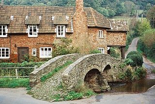
The Gallox Bridge in Dunster, Somerset, England dates from the 15th century. It has been designated as a Grade I listed building and scheduled monument. The bridge is in the guardianship of English Heritage.

Badgworthy Water is a small river which flows through Malmsmead on Exmoor, close to the border between Devon and Somerset, England.
The River Avill is a small river on Exmoor in Somerset, England.

The Dovecot At Blackford Farm in Selworthy on Exmoor within the English county of Somerset was probably built in the 11th century. It is a Grade II* listed building, and scheduled monument.

Barle Bridge is a five span stone arch bridge over the River Barle in Dulverton within the English county of Somerset, which is medieval in origin. It has been scheduled as an ancient monument and is a Grade II listed building.

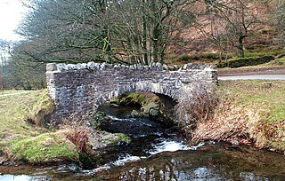
Bury Bridge at Bury in the parish of Brompton Regis within the English county of Somerset is a medieval packhorse bridge. It has been scheduled as an ancient monument and Grade II* listed building.

Malmsmead Bridge is a 17th-century stone bridge which crosses Badgworthy Water in the hamlet of Malmsmead, on the road between Oare and Brendon. The Badgworthy Water forms the boundary between the counties of Somerset and Devon, and the bridge is therefore shared between both counties, as well as being within the Exmoor National Park. It has been scheduled as an ancient monument and is a Grade II listed building.
West Somerset was a local government district in the English county of Somerset. It merged with Taunton Deane to form Somerset West and Taunton on 1 April 2019.
West Somerset was a local government district located in the English county of Somerset. It merged with Taunton Deane to form Somerset West and Taunton on 1 April 2019.

