There are over 20,000 Grade II* listed buildings in England. This page is a list of these buildings in the county of West Sussex by district.
There are over 20,000 Grade II* listed buildings in England. This page is a list of these buildings in the county of West Sussex by district.
| Name | Location | Type | Completed [note 1] | Date designated | Grid ref. [note 2] Geo-coordinates | Entry number [note 3] | Image |
|---|---|---|---|---|---|---|---|
| Kennards | Amberley | Timber-framed house | 17th century or earlier | 15 March 1955 | TQ0315313244 50°54′34″N0°32′03″W / 50.909458°N 0.534182°W | 1353955 |  |
| North Stoke House | North Stoke, Amberley | House | 18th century or earlier | 15 March 1955 | TQ0200410801 50°53′16″N0°33′04″W / 50.887701°N 0.551201°W | 1353956 |  |
| The parish church of St Peter and St Paul | Ashington | Parish church | 15th century | 15 March 1955 | TQ1288415890 50°55′53″N0°23′42″W / 50.931424°N 0.395012°W | 1027442 |  |
| Peppers | Ashurst | House | 1914 | 15 March 1955 | TQ1690416074 50°55′56″N0°20′16″W / 50.932278°N 0.337773°W | 1286873 |  |
| Fossbrooks and Parbrook | Parbrook, Billingshurst | Timber-framed house | 16th century | 22 September 1959 | TQ0741523236 50°59′55″N0°28′14″W / 50.998501°N 0.47064°W | 1027114 |  |
| Ye Old Six Bells Inn | Billingshurst | Inn | 16th century | 22 September 1959 | TQ0862825957 51°01′22″N0°27′09″W / 51.022732°N 0.452546°W | 1027137 |  |
| The parish church of St Giles | Coldwaltham | Parish church | 13th century | 15 March 1955 | TQ0234416540 50°56′21″N0°32′41″W / 50.939231°N 0.544761°W | 1027424 |  |
| Holmbush | Faygate, Colgate | Country house | 1823 | 22 September 1959 | TQ2250933758 51°05′24″N0°15′08″W / 51.09006°N 0.252084°W | 1193998 |  |
| Brook Place | Cowfold | Timber-framed house | 16th century | 22 September 1959 | TQ2153023371 50°59′49″N0°16′10″W / 50.996909°N 0.269539°W | 1027087 |  |
| Capon's Farmhouse | Cowfold | House | c. 1300 | 22 September 1959 | TQ2057722744 50°59′29″N0°17′00″W / 50.991474°N 0.283321°W | 1027095 |  |
| St. Hugh's Charterhouse, Parkminster | Parkminster, Cowfold | Garden wall | 1875–83 | 4 September 1980 | TQ2064420698 50°58′23″N0°16′59″W / 50.97307°N 0.283045°W | 1027084 |  |
| Potwell | Henfield | House | 18th century | 15 March 1955 | TQ2125015884 50°55′47″N0°16′34″W / 50.929674°N 0.27602°W | 1027397 |  |
| Rus House | Henfield | House | Early 19th century | 15 March 1955 | TQ2153015829 50°55′45″N0°16′19″W / 50.92912°N 0.272056°W | 1192586 |  |
| The parish church of St Peter | Henfield | Parish church | c. 1200 | 15 March 1955 | TQ2121216178 50°55′56″N0°16′35″W / 50.932324°N 0.276462°W | 1027400 |  |
| Wantley Manor | Henfield | House | 18th century | 15 March 1955 | TQ2154416308 50°56′00″N0°16′18″W / 50.933423°N 0.271697°W | 1027376 |  Upload Photo |
| Former stables and coach house block at Muntham House School | Barns Green, Itchingfield | Stables | Early 19th century | 22 September 1959 | TQ1239627647 51°02′14″N0°23′54″W / 51.0372°N 0.398321°W | 1354175 | Upload Photo |
| Priest's House | Itchingfield | Clergy house | 15th century | 22 September 1959 | TQ1312928910 51°02′54″N0°23′15″W / 51.048409°N 0.387476°W | 1027046 |  |
| The parish church of St Nicolas | Itchingfield | Parish church | Norman | 22 September 1959 | TQ1313828938 51°02′55″N0°23′14″W / 51.048659°N 0.387339°W | 1193818 |  |
| Springhead Farmhouse | Parham | House | 1811 | 15 March 1955 | TQ0602613314 50°54′34″N0°29′36″W / 50.909568°N 0.493313°W | 1027360 | Upload Photo |
| Wiggonholt House | Wiggonholt, Parham | House | 1811 | 15 March 1955 | TQ0612916713 50°56′24″N0°29′27″W / 50.940103°N 0.49086°W | 1193309 |  |
| New Place Manor | Pulborough | House | Medieval | 15 March 1955 | TQ0534119321 50°57′49″N0°30′05″W / 50.963691°N 0.501318°W | 1027340 |  |
| Old Place | Pulborough | House | 15th century | 15 March 1955 | TQ0452118958 50°57′38″N0°30′47″W / 50.960577°N 0.513095°W | 1286130 |  |
| The Old House | Pulborough | Timber-framed house | 17th century or earlier | 15 March 1955 | TQ0475218739 50°57′31″N0°30′36″W / 50.958567°N 0.50987°W | 1193380 |  |
| The Rectory | Pulborough | Vicarage | Late 18th century | 9 May 1980 | TQ0485518806 50°57′33″N0°30′30″W / 50.95915°N 0.508384°W | 1027312 |  |
| Garlands | The Haven, Rudgwick | Timber-framed house | 17th century or earlier | 22 September 1959 | TQ0821031005 51°04′05″N0°27′25″W / 51.068187°N 0.456997°W | 1354197 |  |
| The parish church of St Giles | Shermanbury | Parish church | 14th century | 15 March 1955 | TQ2142218834 50°57′22″N0°16′21″W / 50.956153°N 0.272591°W | 1194079 |  |
| Barnhouse Farmhouse | Coolham, Shipley | Farmhouse | 17th century or earlier | 22 September 1959 | TQ1256521683 50°59′01″N0°23′52″W / 50.983558°N 0.397759°W | 1180549 |  |
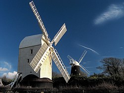
| King's Windmill | Shipley | Corn mill | 1879 | 22 September 1959 | TQ1432421870 50°59′06″N0°22′22″W / 50.984893°N 0.372652°W | 1180806 |  |
| Knepp Castle and stables adjoining to north west | Shipley | Country house | 1800 and 1813 | 22 September 1959 | TQ1564221717 50°59′00″N0°21′14″W / 50.983255°N 0.353932°W | 1354214 |  |
| Arts Centre and Music School at Christ's Hospital | Southwater | Transformer station | 1972–74 | 4 December 2000 | TQ1475028268 51°02′32″N0°21′52″W / 51.042317°N 0.364564°W | 1247243 |  |
| Christ's Hospital: dining hall and water tower to north, school to south, collannaded wings to east and west (chapel in west wing) forming a quadrangle | Southwater | Gate | 1902 | 22 September 1959 | TQ1481228353 51°02′35″N0°21′49″W / 51.043069°N 0.363653°W | 1027034 |  |
| Great House Farmhouse | Southwater | Farmhouse | Late 15th or early 16th century | 27 November 1980 | TQ1531726931 51°01′49″N0°21′25″W / 51.030186°N 0.356905°W | 1286023 | Upload Photo |
| Barn to north west of Charlton Court | Steyning | Tithe barn | Pre-1414 | 9 May 1980 | TQ1690811860 50°53′40″N0°20′21″W / 50.894399°N 0.339065°W | 1180715 |  |
| Chantry House | Steyning | House | 18th century | 15 March 1955 | TQ1771811314 50°53′22″N0°19′40″W / 50.889327°N 0.327728°W | 1194515 |  |
| Charlton House and garden wall, gate and railings to north east | Steyning | Manager's house | Early 18th century | 15 March 1955 | TQ1777411067 50°53′14″N0°19′37″W / 50.887095°N 0.327012°W | 1027280 |  |
| Penfold House and Penfold Lodge | Steyning | House | 18th century | 15 March 1955 | TQ1771911133 50°53′16″N0°19′40″W / 50.8877°N 0.327772°W | 1180501 |  |
| Springwells Hotel | Steyning | House | 18th century | 15 March 1955 | TQ1775511092 50°53′14″N0°19′38″W / 50.887324°N 0.327274°W | 1027281 |  |
| The Stone House | Steyning | House | 1955 | 15 March 1955 | TQ1768811143 50°53′16″N0°19′42″W / 50.887796°N 0.32821°W | 1180508 |  |
| 1, 3 and 5 Church Street | Steyning | House | 18th century | 15 March 1955 | TQ1772011169 50°53′17″N0°19′40″W / 50.888023°N 0.327747°W | 1285733 |  |
| 61, 63 and 65 High Street | Steyning | Jettied house | Early 16th century | 15 March 1955 | TQ1753911292 50°53′21″N0°19′49″W / 50.889166°N 0.330279°W | 1354081 |  |
| Mulberry House | Storrington and Sullington | House | 18th century | 15 March 1955 | TQ0879014320 50°55′05″N0°27′13″W / 50.918097°N 0.453715°W | 1027235 |  |
| The parish church of St Mary the Virgin | Storrington | Parish church | Medieval | 15 March 1955 | TQ0860314079 50°54′57″N0°27′23″W / 50.915966°N 0.456446°W | 1027264 |  |
| West Wantley Farmhouse | Storrington and Sullington | Farmhouse | 1656 | 15 March 1955 | TQ0900015469 50°55′42″N0°27′01″W / 50.928386°N 0.450386°W | 1027238 |  |
| The Blue Idol Meeting House and Guest House | Coolham, Shipley | Farmhouse | 1931 | 15 March 1955 | TQ1073923125 50°59′49″N0°25′24″W / 50.996874°N 0.423323°W | 1181144 |  |
| Church of St Andrew | Edburton, Upper Beeding | Church | 13th century | 15 March 1955 | TQ2330511498 50°53′23″N0°14′54″W / 50.889816°N 0.248273°W | 1354065 |  |
| The parish church of St Peter | Upper Beeding | Parish church | 14th century | 15 March 1955 | TQ1928211134 50°53′15″N0°18′20″W / 50.887388°N 0.305561°W | 1027214 |  |
| Sands | Warnham | House | Mid-16th century | 22 September 1959 | TQ1518234447 51°05′52″N0°21′23″W / 51.09777°N 0.356439°W | 1181536 | Upload Photo |
| South east lodges of Warnham Court School | Warnham | Arch | 1828 | 22 September 1959 | TQ1647632479 51°04′47″N0°20′19″W / 51.07982°N 0.338601°W | 1354221 |  |
| The parish church of St Mary | Washington | Parish church | 12th century | 15 March 1955 | TQ1187512860 50°54′16″N0°24′37″W / 50.904384°N 0.410292°W | 1027198 |  |
| Glebe House | West Grinstead | House | Modern | 22 September 1959 | TQ1719420694 50°58′25″N0°19′56″W / 50.973746°N 0.332162°W | 1026846 |  |
| Old Lock Farmhouse | Lock, West Grinstead | Farmhouse | 1702 | 15 March 1955 | TQ1776918455 50°57′13″N0°19′29″W / 50.953504°N 0.3247°W | 1353982 | Upload Photo |
| Priest's House | West Grinstead | House | Early 18th century | 22 September 1959 | TQ1769021166 50°58′40″N0°19′30″W / 50.977887°N 0.324948°W | 1026840 |  |
| The parish church of St Mary | Wiston Park, Wiston | Parish church | 14th century | 15 March 1955 | TQ1553812393 50°53′58″N0°21′30″W / 50.899465°N 0.358368°W | 1027150 |  |
| The stables to the south east of Wiston House | Wiston Park, Wiston | Stables | 16th century | 9 May 1980 | TQ1553012376 50°53′58″N0°21′31″W / 50.899314°N 0.358487°W | 1182674 | Upload Photo |
| The parish church of St Peter | Woodmancote | Parish church | 13th century | 15 March 1955 | TQ2311715002 50°55′17″N0°14′59″W / 50.921351°N 0.249763°W | 1284248 |  |
| Chesworth House | Horsham | Farmhouse | Late 15th to early 18th century | 22 September 1959 | TQ1761329476 51°03′09″N0°19′24″W / 51.052596°N 0.323353°W | 1027063 |  |
| Horsham Museum | Horsham | House | 19th century | 20 May 1949 | TQ1720230451 51°03′41″N0°19′44″W / 51.061444°N 0.328898°W | 1027542 |  |
| Horsham Park | Horsham | House | Early 18th century | 20 May 1949 | TQ1761730864 51°03′54″N0°19′22″W / 51.065071°N 0.322845°W | 1353938 |  |
| Netherledys the Needles | Horsham | Timber-framed house | 15th or 16th century | 20 May 1949 | TQ1655130138 51°03′32″N0°20′18″W / 51.058763°N 0.338285°W | 1027571 |  |
| North Chapel | Horsham | Farmhouse | 16th century (probably) | 20 May 1949 | TQ1776830862 51°03′54″N0°19′14″W / 51.065022°N 0.320692°W | 1192026 |  |
| Springfield Park | Horsham | Country house | 18th century | 20 May 1949 | TQ1714331192 51°04′05″N0°19′46″W / 51.068116°N 0.3295°W | 1286838 |  |
| St John's College | Horsham | Country house | 1833–35 | 22 September 1959 | TQ1951829649 51°03′14″N0°17′46″W / 51.053758°N 0.296129°W | 1027055 |  |
| St Leonards | Horsham | Country house | Early 19th century | 22 September 1959 | TQ2008530986 51°03′56″N0°17′15″W / 51.065657°N 0.2876°W | 1354200 |  |
| The Manor House | Horsham | Manor house | 1704 | 20 May 1949 | TQ1714430460 51°03′42″N0°19′47″W / 51.061537°N 0.329723°W | 1286966 |  |
![]() Media related to Grade II* listed buildings in West Sussex at Wikimedia Commons
Media related to Grade II* listed buildings in West Sussex at Wikimedia Commons