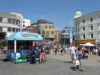
Newtimber

Last updated

Newtimber
North Hill - geograph.org.uk - 377146.jpg
Newtimber Hill
West Sussex UK location map.svg
Red pog.svg
Newtimber
Location within West Sussex
Area6.95 km2 (2.68 sq mi)  [1]
Population96  [1] 2001 Census
  Density 14/km2 (36/sq mi)
OS grid reference TQ271138
  London 41 miles (66 km) N
Civil parish
  • Newtimber
District
Shire county
Region
Country England
Sovereign state United Kingdom
Post town HASSOCKS
Postcode district BN6
Dialling code 01273
Police Sussex
Fire West Sussex
Ambulance South East Coast
UK Parliament
Website Newtimber Parish
List of places
UK
England
West Sussex
50°54′35″N0°11′36″W / 50.90961°N 0.19324°W / 50.90961; -0.19324

Newtimber is a small village and civil parish in the Mid Sussex District of West Sussex, England. It is located north-west of Brighton. The parish also includes the hamlet of Saddlescombe. The parish lies almost wholly with the South Downs National Park, with the exception of a small section of the parish north of the B2117 road. The planning authority for Newtimber is therefore the South Downs National Park Authority (SDNPA), the statutory planning authority for the National Park area. [2] The downland scarp, which includes Newtimber Hill, Newtimber Holt, Saddlescombe chalk quarry and Summer Down, is mostly part of the Beeding Hill to Newtimber Hill, designated Site of Special Scientific Interest.

Contents

The parish covers an area of 695 hectares (1,720 acres). At the 2011 Census the population was included in the civil parish of Poynings.

Listed Buildings and Scheduled Monuments

Newtimber civil parish contains 12 listed buildings. Of these, one is Grade I, one is Grade II* and the remaining 10 buildings are Grade II. The parish contains three scheduled monuments.

Listed buildings

Newtimber church Newtimber church.JPG
Newtimber church

Grade I listed buildings:

Grade II* listed buildings:

Scheduled monuments

Notable buildings and areas

Newtimber
Map

Newtimber is a small parish with a scattered population, which may be as low as seventy five inhabitants. It stretches from the Brighton and Hove downland to its south to the Albourne parish in the Sussex Weald to its north. To its west is the Poynings parish and to its west lies Pyecombe.

Saddlescombe

Saddlescombe Farm Saddlescombe Farm.jpg
Saddlescombe Farm

Saddlescombe ( TQ 272 114 ) is a hamlet in the Newtimber parish; it lies on the road from Poynings to Brighton, 5.4 miles (8.7 km) northwest of Brighton.

Saddlescombe Farm is a busy little place sitting at the base of the Downs which has been owned by the National Trust along with the surrounding countryside since 1995. It has lots of history having been listed as a working farm since the Domesday Book, belonging to the Knights Templar for around 100 years [8] and being one of the two manors of Newtimber Parish. The ancient well in middle of the village green is probably the only visible relic of the manor and the donkey wheel above it that wound up the hamlet's water is still intact. [9] There are rusting iron oxen shoes tacked to the old doorway farmhouse.

The hamlet consists of several threshing barns, large storage barns, a variety of houses, forge, cattle yard and dairy, duck pond, donkey wheel, pig sties, chicken coops and old stables.

Newtimber Place

Newtimber Place, West Sussex Newtimber Place, West Sussex.jpg
Newtimber Place, West Sussex
Big, old, Turkey Oak tree, Newtimber Place Turkey Oak, New Timber Place.jpg
Big, old, Turkey Oak tree, Newtimber Place

Newtimber Place ( TQ 269 137 ) is a 16th-century house, likely built by the sheriff of Sussex, Richard Bellingham. [10] It has a wide moat which goes right up to its walls, with white bridge that is fed by clear, chalk spring water. It has a giant turkey oak tree outside.

To the west of the house is Newtimber Wood ( TQ 266 134 ). This is an intact hazel and hornbeam coppice with fine oaks and ash that borders on Park Wood in the neighbouring parish of Poynings. Both woods are botanically rich.

Down and scarpland

With the exception of the Dyke Golf Course, the Downland scarp is owned by the National Trust and most of it is Open Access.

Newtimber Holt

Newtimber Holt above Beggar's Lane Newtimber Holt.jpg
Newtimber Holt above Beggar's Lane

Newtimber Holt ( TQ 277 126 ) is a rich and ancient woodland with a history possibly going back ten thousand years. There are at least twenty ancient woodland indicator species including wych elm, maple and even midland hawthorn (usually found on the Weald Clay). The Holt doesn't have large-leaved lime anymore, but it does have some very tall large-leaved / small-leaved lime hybrids and these, with the good representation of other trees and shrubs, is indicative of the Holt's age. There are lots of bluebell in spring, with some wood anemone, goldilocks buttercup, yellow archangel, early purple orchis, polypody fern, redcurrant, nettle-leaved bellflower as well as other indicator herbs and grasses of ancient woodland. [10] In May one can find both species of red cardinal beetle sunning themselves on fallen beech boles, for there is an abundance of dead wood. The rotting timber hosts many interesting fungi and slime moulds in autumn.

The Holt is in two very steep combes on the Hill's north eastern corner, but since Victorian times most of the rest of the Hill's northern slope has also grown over into ash, beech and hazel secondary woodland. The Holt is bounded on its south side by the rising bostal bridlepath. There are some big trees including an old beech boundary pollard halfway up the bostal. Sycamore is invading more and more of the wood and is changing its character over time. Roe deer enjoy the deeper parts of the Holt and bird song fills the air at dawn in springtime, but the noise of the nearby A23 means it is no longer a wholly tranquil place.

At the bottom of the Holt is the sunken Beggar's Lane ( TQ 267 126 ) surrounded by high beech trees. The quiet road runs round the north west corner of Newtimber Hill. One can find white helleborine orchis, wood millet and wood melic on its banks. At its southern end it joins the Saddlescombe road, but that is not its original course that the Romans took. Just a few yards to the west and below the busy lane back to Poynings is a wooded terrace which is the original Roman path. [10] If one finds the path, one may also come across a very old and big beech pollard ( TQ 266 123 ).

Newtimber Hill

Newtimber Hill, view from the Newtimber Wood on the north side Newtimber Hill.jpg
Newtimber Hill, view from the Newtimber Wood on the north side

Views from Newtimber Hills western slopes extend all along the ocean wave of the chalk scarp to Hampshire, and across the dim blue forest to Blackdown on the Surrey border. One can find tiny frog orchids and a funny late-flowering form of burnt-tip orchids in its turf. There's a ribbon of tormentil where the chalky slopes break to meet the acidic plateau top. There are anthills, cattle terracettes and some years dark green fritillary, the rare silver-spotted skipper butterfly and a big populations of glowworm.

On the west flank of Newtimber Hill, above and below the Saddlescombe Road, are disused braided trackways, that are known locally as the ‘Devil's Stairs’. In this area lives a population of ancient juniper, our most special and rarest native bushy species. Some of the bushes may be as old as four hundred years, despite being only ten metres (thirty foot) or so high. The bushes' ancestors are likely some of the first woody species re-colonizing postglacial Britain, as it is a classic species of the cold tundra grasslands. Unfortunately, the Newtimber junipers are the only native ones on the Brighton Downs, despite Wolley-Dod in 1937 recording it as being abundant to the west of Brighton and present if rare to the east. [11] The National Trust and the Sussex Wildlife Trust are now bravely restoring the juniper's old Down pasture habitat and it is being planted on the A27 bypass at Stanmer and Devil's Dyke.

On the top of Newtimber Hill there are two dew ponds ( TQ 272 123 ), one which is dried and now covered with colourful with waxcaps and the other a restored dew pond with much pond life. South of the dew ponds the plateau descends by a staircase of medieval strip lynchets to the combe of sheltered Saddlescombe. The lynchets are chalky in character with nice flowers and old meadow fungi, with waxcap (meadow, crimson and scarlet hood) with scatters of earth tongues and clumps of five or six species of coral fungi.

North, East and West Hill

Downland above Brighton Downland above Brighton - geograph.org.uk - 54922.jpg
Downland above Brighton

North, East and West Hill all surround Saddlecombe. North Hill ( TQ 270 120 ) has two prominent Bronze Age barrows in which, despite being previously robbed, archeologists found pottery vessels, a skeleton and a dagger. [12] [5] The barrows themselves sit at the top of the hill in an island of old acid grassland. There are treasures still there in the form of betony, eggs and bacon, tormentil and knapweed, and in autumn (in a good year) a real cornucopia of colourful waxcaps, coral fungi and earth tongues, including several old pasture indicator species. West Hill has some pristine old chalk grassland with an up-slope fringe of scrub and some rare dyer’s greenweed.

Saddlescombe chalk quarry

Saddlescombe pit Saddlescombe pit - geograph.org.uk - 388221.jpg
Saddlescombe pit

Saddlescombe chalk quarry ( TQ 270 116 ) still has the old limekilns under some big old bushes. There are chalk-loving mosses, waxcaps and earth tongues on the terracettes. There are many butterflies, including the adonis blue, in summer but the grayling butterfly has now gone and there is only one site in Sussex where it remains. [13]

Cross Dyke

There's a cross dyke ( TQ 275 124 )) between West Hill and Newtimber Hill, along the line of the bridlepath, which is believed to be a prehistoric land boundary. It is now a scheduled monument. [7]

Summer Down

Bridleway, Summer Down Bridleway, Summer Down - geograph.org.uk - 1640552.jpg
Bridleway, Summer Down

Summers Down ( TQ 267 110 ) is a bushy acid grassland with lots of sheltered places and a good view of the Poynings Gap. The place was a pagan Saxon cemetery, the site of an old windmill, and a small cross dyke, [6] but they are difficult to make out. South of the road, the National Trust car park has three Bronze Age bowl barrows still upstanding, both with their tops dug out by treasure seekers of the past. [6]

Part of Summer Down ( TQ 272 111 ) is fenced off from Summer Down road on its south side, though it is scored with the deep-cut braided paths of that road. The cut up tracks are three metres (ten feet) deep caused by centuries of passage by pack horse trains, carts and flocks. These are deeper than the ditches of the Devil's-Dyke hillfort.

Ewe Bottom

Ewe Bottom Fourteen Acre Bottom - geograph.org.uk - 1640376.jpg
Ewe Bottom

Most of Ewe Bottom ( TQ 267 106 ) used to be part of Saddlescombe's sheep pastures, although the area west of the bridlepath was part of Poynings’ pastures. Since the construction of the golf course, it has been left largely derelict and the gorse and thorn on its valley sides have spread across the entire valley. Now the side of the valley itself is growing into ash woodland in the next stage of this long succession. There are very large, old hawthorn bushes in these thickets, which can be seen along the footpath on the south-east perimeter of the golf course ( TQ 270 100 ).

Pond Brow

Pond Brow ( TQ 271 105 ) has two peaceful old dew ponds which watered these great pastures, which were known as West Down. [10] Now they are fenced off from the golf course and are used by the sheep on the ex-arable land below. The ponds’ are fringed with flote grass, shaded by gorse and thorn draped with honeysuckle.

The valley sides south of Pond Brow were also part of West Down and tiny fragments of old flower-rich pastures survive on the steepest parts. Where those pastures met the road ( TQ 275 103 ) the verges are still colourful with old Downland herbs including swarms of spotted orchid, many vetches, including grass vetchling, and pea family herbs. [10]

Dyke Golf Course

Dyke Access Trail Dyke Access Trail - geograph.org.uk - 36803.jpg
Dyke Access Trail

The Devil's Dyke Golf Course ( TQ 265 103 ) was founded in 1908, although there was a women's course that pre-dated it. [14] It was badly damaged in the Second World War when it was used for tank training, but Brighton Council rebuilt it. [14]

The course has lost almost all of its old Down pasture flowers, but remarkably, many of the old meadow fungi seem to have survived. At least fourteen have been found there including waxcaps and coral fungi.

East of the bridlepath there is a spot, now largely forgotten, which used to be called Beggar's Haven ( TQ 266 104 ) where a curled up skeleton was unearthed in Victorian times with a necklace of beads of lignite and tubular beads of bronze.Accompanying it was a decorated pottery ‘beaker’ nearly five inches wide of a type found at several sites on these Downs. [12] Probably a burial mound once rose above this early Bronze Age burial, but it isn't there anymore.

Related Research Articles

<span class="mw-page-title-main">Brighton and Hove</span> City and unitary authority in England

Brighton and Hove is a unitary authority with city status in East Sussex, England. There are multiple villages alongside the seaside resorts of Brighton and Hove in the district. It is administered by Brighton and Hove City Council, which is currently under Labour majority control.

<span class="mw-page-title-main">Shoreham-by-Sea</span> Town in West Sussex, England

Shoreham-by-Sea is a coastal town and port in West Sussex, England.

<span class="mw-page-title-main">Falmer</span> Village near Brighton, England

Falmer is a small village and civil parish in the Lewes District of East Sussex, England, lying between Brighton and Lewes, approximately five miles (8 km) north-east of the former. It is also the site of Brighton & Hove Albion's Falmer Stadium.

<span class="mw-page-title-main">Ditchling</span> Village in East Sussex, England

Ditchling is a village and civil parish in the Lewes District of East Sussex, England. The village is contained within the boundaries of the South Downs National Park; the order confirming the establishment of the park was signed in Ditchling.

<span class="mw-page-title-main">Hassocks</span> Large village in Sussex, England

Hassocks is a village and civil parish in the Mid Sussex District of West Sussex, England. Its name is believed to derive from the tufts of grass found in the surrounding fields.

<span class="mw-page-title-main">Upper Beeding</span> Human settlement in England

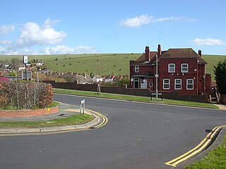
Upper Beeding is a village and civil parish in the Horsham District of West Sussex, England. It is located at the northern end of the River Adur gap in the South Downs, four miles (6.4 km) north of Shoreham-by-Sea and has a land area of 1,877 hectares. The site is a bridging point over the river: on the opposite bank are Bramber and Steyning, making the whole area somewhat built-up. The civil parish also includes the smaller village of Small Dole to the north, and the village of Edburton to the northeast.

<span class="mw-page-title-main">Hamsey</span> Village in East Sussex, England

Hamsey is a civil parish in the Lewes District of East Sussex, England. The parish covers a large area and consists of the villages of Hamsey, Offham and Cooksbridge. The main centres of population in the parish are now Offham and Cooksbridge. Around the main settlements are enlarged fields, isolated old cottages and farms. The winding and undulating parish lanes between banks, old hedge rows, trees, flowery verges and ditches are popular with cyclists and give good views of the Downs.

<span class="mw-page-title-main">Kingston near Lewes</span> Village in East Sussex, England

Kingston near Lewes is a village and civil parish in the Lewes District of East Sussex, England. The village is mentioned in the Domesday Book and is located two miles (3.2 km) south of Lewes and is nestled in the South Downs. The parish is par of two Sites of Special Scientific Interest: the Lewes Brooks and Kingston Escarpment and Iford Hill.

<span class="mw-page-title-main">Plumpton, East Sussex</span> Village in East Sussex, England

Plumpton is a village and civil parish in the Lewes District of East Sussex, England. The village is located five miles (8 km) north-west of Lewes. The parish measures 6.5 miles in length on its north–south axis and 1 mile at its widest on the B2116 Underhill Road. The southern half of the parish lies within the South Downs National Park and at the highest point, 214m (702 feet), the South Downs Way traverses the crest of Plumpton Plain. The parish includes the small village of Plumpton adjacent to the Downs and to the north the larger village of Plumpton Green where most of the community and services are based. Plumpton is known for its race course, and also Plumpton College, which farms over 2500 acres of land and has become one of the leading centres for land-based education in the UK.

<span class="mw-page-title-main">Westmeston</span> Village in East Sussex, England

Westmeston is a village and civil parish in the Lewes District of East Sussex, England heavily dependent in amenities on larger Ditchling to the near-immediate northwest. It is four miles (6 km) south-southeast of Burgess Hill and (10 km) west of Lewes, on the northern slopes of the South Downs.

<span class="mw-page-title-main">Fulking</span> Human settlement in England

Fulking is a village and civil parish in the Mid Sussex District of West Sussex, England. The parish lies wholly with the South Downs National Park.

<span class="mw-page-title-main">Poynings</span> Village and civil parish in West Sussex, England

Poynings is a village and civil parish in the Mid Sussex District of West Sussex, England. The parish lies wholly with the South Downs National Park. To its south is Brighton and Hove, to its west is the Fulking parish, to its east is the Newtimber parish and to its north is Albourne parish. The planning authority for Poynings is the South Downs National Park Authority (SDNPA), the statutory planning authority for the National Park area.

<span class="mw-page-title-main">Pyecombe</span> Human settlement in England

Pyecombe is a village and civil parish in the Mid Sussex District of West Sussex, England. Pyecombe is located 7 miles (11 km) to the north of Brighton. The civil parish covers an area of 887 hectares and has a population of 200, increasing at the 2011 Census to a population of 237.

<span class="mw-page-title-main">Woodingdean</span> Suburb of Brighton, England

Woodingdean is an eastern suburb of the city of Brighton and Hove, East Sussex, separated from the main part of the city by downland and the Brighton Racecourse. The name Woodingdean came from Woodendean Farm which was situated in the south end of what is now Ovingdean.

<span class="mw-page-title-main">Hangleton</span> Suburb of Hove, Sussex, England

Hangleton is a suburb of Brighton and Hove, in the ceremonial county of East Sussex, England. The area was developed in the 1930s after it was incorporated into the Borough of Hove, but has ancient origins: its parish church was founded in the 11th century and retains 12th-century fabric; the medieval manor house is Hove's oldest secular building. The village became depopulated in the medieval era and the church fell into ruins, and the population in the isolated hilltop parish only reached 100 in the early 20th century; but rapid 20th-century development resulted in more than 6,000 people living in Hangleton in 1951 and over 9,000 in 1961. By 2013, the population exceeded 14,000.

<span class="mw-page-title-main">Patcham</span> Human settlement in England

Patcham is a suburb in the city of Brighton and Hove, in the ceremonial county of East Sussex, England. It is about 3 miles (5 km) north of the city centre. It is bounded by the A27 to the north, Hollingbury to the east and southeast, Withdean to the south and the Brighton Main Line to the west. The A23 passes through the area.

<span class="mw-page-title-main">Clayton to Offham Escarpment</span> Landform in Sussex, England

Clayton to Offham Escarpment is a 422.5-hectare (1,044-acre) linear biological Site of Special Scientific Interest (SSSI) which runs from Clayton in West Sussex to Lewes in East Sussex. Its ownership and management is divided between over fifteen landowners and farmers. Parts of Ditchling's Downs, e.g. TQ 323 133, and the scarp between Blackcap and Mount Harry, e.g. TQ 378 124, are owned by the National Trust. What remains of Ditchling Tenantry Down common at Ditchling Beacon is leased to the Sussex Wildlife Trust.

<span class="mw-page-title-main">Blackcap, East Sussex</span> Hill in East Sussex, England

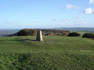
Blackcap is a hill and nature reserve in East Sussex, England. It is on a peak of the South Downs, just south east of Plumpton and west of Lewes. The flatter landscape is made up of open ground with chalk paths, surrounded by thickets. The steeper ground leading up to the ridge is low-density woodland. The top is more open, with patches of pine woodland and gorse bushes.

<span class="mw-page-title-main">Westdene</span> Human settlement in England

Westdene is an area of the city of Brighton and Hove, East Sussex. It is an affluent northern suburb of the city, west of Patcham, the A23 and the London to Brighton railway line, north of Withdean and northeast of West Blatchington. It is on the Brighton side of the historic parish boundary between Brighton and Hove and is served by Preston Park railway station. It is known for its greenery and woodland and is very close to the South Downs, from which it is separated by the Brighton Bypass, and was built on the slopes of two hills.

<span class="mw-page-title-main">Beeding Hill to Newtimber Hill</span>

Beeding Hill to Newtimber Hill is a 321 ha (790-acre) biological and geological Downland Site of Special Scientific Interest (SSSI) north of Shoreham-by-Sea in West Sussex. It is a Nature Conservation Review site, Grade 2, and it includes Devil's Dyke Geological Conservation Review site.

References

  1. 1 2 "2001 Census: West Sussex – Population by Parish" (PDF). West Sussex County Council. Archived from the original (PDF) on 8 June 2011. Retrieved 10 April 2009.
  2. "Planning". South Downs National Park. South Downs National Park Authority. Retrieved 1 February 2020.
  3. Historic England. "Newtimber Place (1025629)". National Heritage List for England .
  4. Historic England. "The Parish Church of St John Evangelist (1354879)". National Heritage List for England .
  5. 1 2 Historic England. "Bowl barrow on North Hill (1014949)". National Heritage List for England .
  6. 1 2 3 Historic England. "Group of three bowl barrows and an Anglo-Saxon mixed cemetery on Summer Down (1014952)". National Heritage List for England .
  7. 1 2 Historic England. "Cross dyke on Newtimber Hill (1015717)". National Heritage List for England .
  8. Houses of Knights Templar - Preceptory of Saddlescombe | A History of the County of Sussex: Volume 2 (pp. 92)
  9. 'Parishes: Newtimber', in A History of the County of Sussex: Volume 7, the Rape of Lewes, ed. L F Salzman (London, 1940), pp. 204-208. British History Online http://www.british-history.ac.uk/vch/sussex/vol7/pp204-208
  10. 1 2 3 4 5 Bangs, David (2018). Land of the Brighton line : a field guide to the Middle Sussex and South East Surrey Weald. [Brighton]. ISBN   978-0-9548638-2-1. OCLC   1247849975.{{cite book}}: CS1 maint: location missing publisher (link)
  11. Wolley-Dod, A. H. (1937). Flora of Sussex. Kenneth Saville. Page 94
  12. 1 2 Curwen, E.C. 1954. The Archaeology of Sussex. London, Methuen and Co. Ltd. Page 159
  13. Kalaher, Martin (2016). "Grayling". Butterfly Conservation - Sussex Branch. Retrieved 11 September 2021.
  14. 1 2 "Brighton & Hove Ladies' Golf Club. (1892 - WW2)". Golfs missing links. Retrieved 11 September 2021.