
The A23 road is a major road in the United Kingdom between London and Brighton, East Sussex, England. It is managed by Transport for London for the section inside the Greater London boundary, Surrey County Council and West Sussex County Council for the section shadowed by the M23 motorway, National Highways between the M23 and Patcham, and by Brighton and Hove Council from the A27 to the centre of Brighton.

Haywards Heath is a town in West Sussex, England, 36 miles (58 km) south of London, 14 miles (23 km) north of Brighton, 13 miles (21 km) south of Gatwick Airport and 31 miles (50 km) northeast of the county town, Chichester. Nearby towns include Burgess Hill to the southwest, Horsham to the northwest, Crawley northwest and East Grinstead northeast. With only a relatively small number of jobs available in the immediate vicinity, mostly in the agricultural or service sector, many residents work remotely or commute daily via road or rail to London, Brighton, Crawley or Gatwick Airport.
Pease Pottage is a village in the Mid Sussex District of West Sussex, England. It lies on the southern edge of the Crawley built-up area, in the civil parish of Slaugham.

Cuckfield is a village and civil parish in the Mid Sussex District of West Sussex, England, on the southern slopes of the Weald. It lies 34 miles (55 km) south of London, 13 miles (21 km) north of Brighton, and 31 miles (50 km) east northeast of the county town of Chichester. Nearby towns include Haywards Heath to the southeast and Burgess Hill to the south. It is surrounded on the other sides by the parish of Ansty and Staplefield formerly known as Cuckfield Rural.

Maresfield is a village and civil parish in the Wealden District of East Sussex, England. The village itself lies 1.5 miles (2.4 km) north from Uckfield; the nearby villages of Nutley and Fairwarp; and the smaller settlements of Duddleswell and Horney Common; and parts of Ashdown Forest all lie within Maresfield parish.

Charlwood is a village and civil parish in the Mole Valley district of Surrey, England. It is immediately north-west of London Gatwick Airport in West Sussex, close west of Horley and north of Crawley. The historic county boundary between Surrey and Sussex ran to the south of Gatwick Airport. Boundaries were reformed in 1974 so that the county boundary between Surrey and West Sussex, delineated by the Sussex Border Path, now runs along the northern perimeter of the airport, and the southern extent of Charlwood.
Ardingly is an English village and civil parish in the Mid Sussex district of West Sussex, England. The village is in the High Weald Area of Outstanding Natural Beauty about 33 miles (53 km) south of London and 33 miles (53 km) east-north-east of the county town of Chichester. The parish covers an area of 3,974 acres (1,608 ha). The 2011 Census recorded a population of 1,936 an increase from 1,833 in 2001.
Billingshurst is a village and civil parish in the Horsham District of West Sussex, England. The village lies on the A29 road at its crossroads with the A272, 6 miles (10 km) south-west of Horsham and 5.5 miles (9 km) north-east of Pulborough.

Bolney is a village and civil parish in the Mid Sussex district of West Sussex, England. It lies 36 miles (58 km) south of London, 11 miles (18 km) north of Brighton, and 27 miles (43 km) east northeast of the county town of Chichester, near the junction of the A23 road with the A272 road. The parish has a land area of 1,479.41 hectares. In the 2001 census there were 1209 people living in 455 households of whom 576 were economically active. At the 2011 Census the population had increased to 1,366. Nearby towns include Burgess Hill to the southeast and Haywards Heath to the east.

Frant is a village and civil parish in the Wealden District of East Sussex, England, on the Kentish border about three miles (5 km) south of Royal Tunbridge Wells.

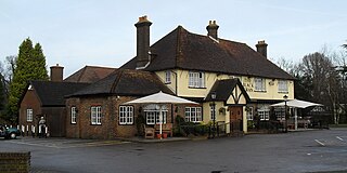
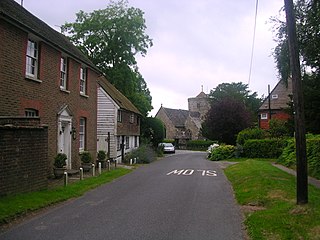
Slaugham is a village and civil parish in the Mid Sussex District of West Sussex, England. It is located 7 miles (11 km) to the south of Crawley, on the A23 road to Brighton. The civil parish covers an area of 2,432 hectares. At the 2001 census it had a population of 2,226 persons of whom 1,174 were economically active. At the 2011 Census the parish included the villages of Handcross and Warninglid and had a population of 2,769. In addition the parish contains the settlement of Pease Pottage.
Twineham is a village and civil parish in the Mid Sussex District of West Sussex, England. It is located eight kilometres to the west of Burgess Hill. The civil parish covers an area of 784 hectares In the 2001 census 271 people lived in 100 households, of whom 139 were economically active. The 2011 Census population was 306.

Handcross is a village in the Mid Sussex District of West Sussex, England. It lies on the A23 road 4.2 miles south of Crawley. At the 2011 Census the population fell within the civil parish of Slaugham.

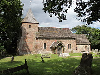
St John the Baptist's Church is an Anglican church in Crawley, West Sussex, England. It is the parish church of Crawley, and is the oldest building in the town centre, dating from the 1250—although many alterations have been made since, and only one wall remains of the ancient building. In September 2017, a team from St Peter's Brighton began a new phase in the life of St John's Crawley. St John's offer a variety of services, traditional and informal, and contemporary services.

Hurstpierpoint & Bolney is an electoral division of West Sussex in the United Kingdom, and returns one member to sit on West Sussex County Council.

Worth Forest is an electoral division of West Sussex in the United Kingdom, and returns one member to sit on West Sussex County Council.

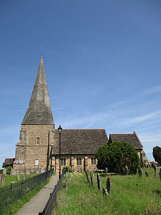
St Mary's Church is an Anglican church in the village of Slaugham in Mid Sussex, one of seven local government districts in the English county of West Sussex. The 12th- and 13th-century church, restored in the Victorian era, serves a large rural area of the Sussex Weald, covering three villages as well as the ancient settlement of Slaugham. It also controlled the church in the market town of Crawley—now one of the area's largest towns—for the first few centuries of its existence. A locally important family built a private chapel in the church in the 17th century, and a series of memorials to deceased family members are considered to be excellent examples of their type. English Heritage has listed the building at Grade II* for its architectural and historical importance.

Albert Cordingley was an English professional cricketer from Yorkshire who played first-class cricket for Sussex in the early years of the 20th century.


