
Mendlesham is a village in Suffolk with 1,407 inhabitants at the 2011 census. It lies 5 miles (8 km) north east of Stowmarket and 73.135 miles (117.699 km) from London.

Poling is a village and civil parish in the Arun District of West Sussex, England, 2 miles (3.2 km) southeast of Arundel on a minor road south of the A27. About 25% of the parish is wooded foothill slopes of the South Downs which is the area north of the A27 here.

Barnham is a village, Anglican parish and former civil parish, now in the civil parish of Barnham and Eastergate, in the Arun district of West Sussex, England, centred about 5 miles (8.0 km) north of Bognor Regis. On 1 April 2019 the parish was merged with Eastergate to form "Barnham and Eastergate". In 2011 the parish had a population of 1391.
Binsted is a village and large civil parish in East Hampshire, England. It is about 4.1 miles (6.6 km) east of Alton, its nearest town. The parish is one of the largest in northern Hampshire and covers almost 7,000 acres (2,800 ha). It contains two villages, Bucks Horn Oak and Holt Pound, as well as two hamlets, Wyck and Wheatley. The parish also covers the entirety of the Alice Holt Forest, a royal forest situated near the border with Surrey. The nearest railway station is 1.8 miles (2.9 km) northeast of the village, at Bentley. According to the 2011 census, the parish had a population of 1,817 people.

South Stoke is a rural village and civil parish in the Arun District of West Sussex, England. It is centred two miles (3 km) north of Arundel also on the west bank of the River Arun and on the edge of Arundel Park. It is reached by road, footpath or river from Arundel. A footpath also leads to North Stoke on the east bank. The civil parish, which includes the hamlet of Offham, covers an area of 534.86 hectares. At the 2011 Census the population of the village was included in the civil parish of Houghton.

Yapton is a village and civil parish in the Arun District of West Sussex, England. It is centred three miles (4.8 km) north east of Bognor Regis at the intersection of the B2132 and B2233 roads.

Kington St Michael is a village and civil parish about 3 miles (4.8 km) north of Chippenham in Wiltshire, England.

Grittleton is a village and civil parish in Wiltshire, England, 6 miles (10 km) northwest of Chippenham. The parish includes the hamlets of Foscote, Leigh Delamere, Littleton Drew and Sevington, and part of the hamlet of The Gibb.

North Stoke is a village and former civil parish, now in the parish of Amberley, in the Horsham district of West Sussex, England. It is just over 2 miles (3 km) north of Arundel and 0.7 miles (1 km) south of Amberley railway station, and is at the end of a no through road from the station. In 1931 the parish had a population of 70. On 1 April 1933 the parish was abolished and merged with Amberley.

Tortington is a small village and former civil parish, now in the parish of Arundel, in the Arun district of West Sussex, England. It lies between the Arundel to Ford and the Arundel to Chichester roads, 1.6 miles (2.6 km) southwest of Arundel. In 1961 the parish had a population of 617. On 1 April 1985 the parish was abolished and merged with Arundel, Ford, Slindon and Walberton.

St Margaret's Church is an Anglican church in the Ifield neighbourhood of Crawley, a town and borough in West Sussex, England. It is the ancient parish church of the village of Ifield; the medieval settlement was expanded to form one of the New Town of Crawley's 13 neighbourhoods, and the church's modern parish now serves several other neighbourhoods as well.
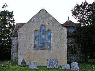
Coombes Church is a Church of England parish church in the rural hamlet of Coombes in the Adur District of West Sussex, England. It has served the rural parish, northwest of Shoreham-by-Sea and next to the River Adur, since the 11th century. Despite several re-buildings, some structural elements remain from that period. An important series of wall paintings, dating from the 12th to the 18th century, were uncovered in 1949. English Heritage has listed the church at Grade I for its architectural and historical importance.

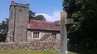
St Mary's Church is an Anglican church in the village of Walberton in the district of Arun, one of seven local government districts in the English county of West Sussex. Its 11th-century origins are now mostly hidden behind the results of extensive restoration work undertaken since the 18th century; but some Saxon-era fragments remain, and reused Roman building materials can still be seen in the walls. The extensive collection of 18th-century gravestones in the churchyard includes some especially macabre examples. The church is protected as a Grade I Listed building.
St Mary the Virgin is the Church of England parish church of Lytchett Matravers in Dorset. Its parish is part of the Diocese of Salisbury. The building is Grade I listed.
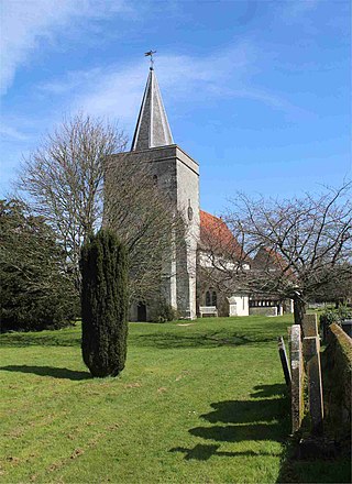
North Stoke Church, rededicated in 2007 to St Mary the Virgin after its medieval dedication was unexpectedly rediscovered, is a former Church of England parish church in the riverside hamlet of North Stoke in the Horsham District of West Sussex. The partly 11th-century cruciform building, set in an almost deserted village in a loop of the River Arun, is mostly unrestored and stands on an ancient earthwork which has pre-Christian origins. The building has architectural features and internal fittings spanning hundreds of years, including some very old stained glass and wall paintings, although there are few memorials compared with other Sussex churches of a similar age. The church, "movingly eloquent of centuries of remote Sussex agricultural life", is no longer used for worship: it was declared redundant in 1992, after which it was entrusted to the Churches Conservation Trust. English Heritage lists the church at Grade I for its architectural and historical importance.

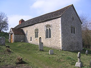
St Mary Magdalene's Church is the former Anglican parish church of the hamlet of Tortington in the district of Arun, one of seven local government districts in the English county of West Sussex. Founded in the 12th century to serve a priory and villagers in the riverside location, it has experienced little change despite a 19th-century restoration. Its ancient chancel arch and doorway have remarkable carvings with "grotesque, boggle-eyed monsters", rare beakhead figures and chevron ornamentation. Standing in a picturesque setting behind a farm, the flint and Caen stone building was used for worship until 1978, when it was declared redundant. It is now cared for by the Churches Conservation Trust, and English Heritage has listed it at Grade II for its architectural and historical importance. The church is dedicated to Jesus's companion Mary Magdalene.

Knaith is a village and civil parish about 3 miles (5 km) south of the town of Gainsborough in the West Lindsey district of Lincolnshire, England. The population of the civil parish at the 2011 census was 335.

Northorpe is a village and civil parish in the West Lindsey district of Lincolnshire, England, about 8 miles (13 km) north-east from the town of Gainsborough. The population of the civil parish at the 2011 census was 126.
Sussex in the High Middle Ages includes the history of Sussex from the Norman Conquest in 1066 until the death of King John, considered by some to be the last of the Angevin kings of England, in 1216. It was during the Norman period that Sussex achieved its greatest importance in comparison with other English counties. Throughout the High Middle Ages, Sussex was on the main route between England and Normandy, and the lands of the Anglo-Norman nobility in what is now western France. The growth in Sussex's population, the importance of its ports and the increased colonisation of the Weald were all part of changes as significant to Sussex as those brought by the neolithic period, by the Romans and the Saxons. Sussex also experienced the most radical and thorough reorganisation of land in England, as the Normans divided the county into five tracts of lands called rapes. Although Sussex may have been divided into rapes earlier in its history, under the Normans they were clearly administrative and fiscal units. Before the Norman Conquest Sussex had the greatest concentration of lands belonging to the family of Earl Godwin. To protect against rebellion or invasion, the scattered Saxon estates in Sussex were consolidated into the rapes as part of William the Conqueror's 'Channel march'.


