Pagham

Last updated

Pagham
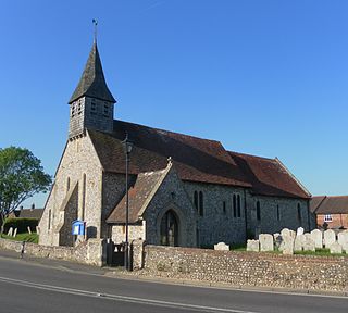
St Thomas a Becket's Church, Pagham (NHLE Code 1353906).JPG
St Thomas a Becket Church
West Sussex UK location map.svg
Red pog.svg
Pagham
Location within West Sussex
Area9.88 km2 (3.81 sq mi)
Population5,941 (Civil Parish.2011) [1]
  Density 601/km2 (1,560/sq mi)
OS grid reference SZ886975
  London 57 miles (92 km) NNE
Civil parish
  • Pagham
District
Shire county
Region
Country England
Sovereign state United Kingdom
Post town BOGNOR REGIS
Postcode district PO21
Dialling code 01243
Police Sussex
Fire West Sussex
Ambulance South East Coast
UK Parliament
Website http://www.paghamcouncil.co.uk/
List of places
UK
England
West Sussex
50°46′15″N0°44′41″W / 50.77083°N 0.74479°W / 50.77083; -0.74479

Pagham is a coastal village, Anglican parish [2] and civil parish in the Arun district of West Sussex, England, with a population of around 6,100. It lies about two miles to the west of Bognor Regis.

Contents

Demography

Pagham is part of the electoral ward called Pagham and Rose Green. The population of this ward at the 2011 census was 7,538. [3]

The village can be divided into three contiguous neighbourhoods (merging seamlessly as one clustered village):

History

Pagham was a significant settlement at the time of the Domesday survey of 1086 with 154 households. [4]

In 1861 the parish, which is in the Diocese of Chichester, [5] extended to 4,376 acres (1,771 ha), with a population of 988. [2]

Landmarks

Map of Nature Reserve Pagham Harbour Local Nature Reserve information board - close-up - geograph.org.uk - 2257397.jpg
Map of Nature Reserve

The Site of Special Scientific Interest known as Pagham Harbour is to the southwest; almost one quarter of the area falls within the parish. [6] The harbour and surrounding land is of national importance for both flora and fauna. The shingle spit is of geological interest.

A Phoenix breakwater, a concrete caisson that was intended to be part of a World War II Mulberry Harbour, is visible in the bay at low tides.

Buildings and facilities

Many of the original Pagham Beach dwellings are bungalows constructed from old railway carriages - most of these have been later rebuilt using sturdier construction methods.

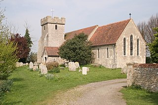
The Church of St. Thomas a'Becket contains three 1911 windows by the leading painter and designer Edward Arthur Fellowes Prynne, which were restored in 2011. [7] Pagham is home to ale and beer pubs 'The Lamb', 'The Lion' and 'The Bear' as well as the 'Inglenook Hotel'.

Sport and leisure

Colin Cooper (left) and entry in the 2023 Pagham Pram Race Lord of the Rings.png
Colin Cooper (left) and entry in the 2023 Pagham Pram Race

Pagham has a Non-League football club Pagham F.C. who play at Nyetimber Lane. The village has a cricket team, who play at the cricket ground at Nyetimber Lane. Sussex County Cricket Club played two first-class matches there in the 1970s. [8]

Pagham is the home of the Pagham Pram Race which is the oldest pram race in the world. The race is run on Boxing day every year at 11am whatever the weather. Thousands of people line the streets of Pagham to watch the wacky contestants navigate the 3 mile course, drinking 3 pints of beer en route. All the money raised by the Pram Race is distributed to local good causes. The most successful fancy dress racer is Colin Cooper, who has won 2 best fancy dress awards alongside his teammates. [9]

Notable people

James Byden, Joe Biden's paternal fourth great-grandfather was christened at the church of St Thomas à Becket in Pagham, on November 15, 1767. [10] [11] He was the son of Richard Byden, Biden's paternal fifth great-grandfather, and his wife Susan. The parish register notes that they were from Wymering where Richard appears to have been buried in 1808. [12]

The motor racing drivers John Watson and Derek Bell lived in Pagham. Watson won five Formula One Grand Prix. Bell won the Le Mans 24 hour race five times. [13]

See also

Related Research Articles

<span class="mw-page-title-main">West Sussex</span> County of England

West Sussex is a ceremonial county in South East England. It is bordered by Surrey to the north, East Sussex to the east, the English Channel to the south, and Hampshire to the west. The largest settlement is Crawley, and the county town is the city of Chichester.

<span class="mw-page-title-main">Bognor Regis</span> Town in West Sussex

Bognor Regis, also known as Bognor, is a town and seaside resort in West Sussex on the south coast of England, 56 miles (90 km) south-west of London, 24 miles (39 km) west of Brighton, 6 miles (10 km) south-east of Chichester and 16 miles (26 km) east of Portsmouth. Other nearby towns include Littlehampton east-north-east and Selsey to the south-west. The nearby villages of Felpham, and Aldwick are now suburbs of Bognor Regis, along with those of North and South Bersted. The population of the Bognor Regis built-up area, including Felpham and Aldwick, was 63,855 at the 2011 census.

<span class="mw-page-title-main">Selsey</span> Seaside town and civil parish in West Sussex, England

Selsey is a seaside town and civil parish, about eight miles (12 km) south of Chichester in West Sussex, England. Selsey lies at the southernmost point of the Manhood Peninsula, almost cut off from mainland Sussex by the sea. It is bounded to the west by Bracklesham Bay, to the north by Broad Rife, to the east by Pagham Harbour and terminates in the south at Selsey Bill. There are significant rock formations beneath the sea off both of its coasts, named the Owers rocks and Mixon rocks. Coastal erosion has been an ever-present problem for Selsey.

<span class="mw-page-title-main">Boxgrove</span> Village and parish in West Sussex, England

Boxgrove is a village, ecclesiastical parish and civil parish in the Chichester District of the English county of West Sussex, about 3.5 miles (5.6 km) north east of the city of Chichester. The village is just south of the A285 road which follows the line of the Roman road Stane Street.

<span class="mw-page-title-main">Bosham</span> Human settlement in England

Bosham is a coastal village, ecclesiastical parish and civil parish in the Chichester District of West Sussex,within the historic county of West Sussex, England, centred about 2 miles (3.2 km) west of Chichester with its clustered developed part west of this. Its land forms a broad peninsula projecting into natural Chichester Harbour where Bosham has its own harbour and inlet on the western side.

<span class="mw-page-title-main">Aldwick</span> Village and parish in West Sussex, England

Aldwick is a seaside village and civil parish in the Arun district of West Sussex, England. Bognor Regis is to the east of the village. The ecclesiastical parish, formerly part of Pagham includes the smaller settlement of Rose Green.
<span class="mw-page-title-main">West Tarring</span> Human settlement in England

West Tarring or simply Tarring, is a neighbourhood of Worthing, in the borough of Worthing in West Sussex, England. It lies on the A2031 road 1 mile (1.6 km) north-west of the town centre. It is called "West Tarring", or less commonly "Tarring Peverell", to differentiate it from Tarring Neville near Lewes.

<span class="mw-page-title-main">Westbourne, West Sussex</span> Human settlement in England

Westbourne is a village, civil parish and electoral ward in the Chichester District of West Sussex, England. It is located 0.5 miles (0.80 km) north east of Emsworth. The parish includes the hamlets of Woodmancote and Aldsworth, and once included the settlements of Southbourne and Prinsted to the south.

<span class="mw-page-title-main">Barnham, West Sussex</span> Village in West Sussex, England

Barnham is a village, Anglican parish and former civil parish, now in the civil parish of Barnham and Eastergate, in the Arun district of West Sussex, England, centred about 5 miles (8.0 km) north of Bognor Regis. On 1 April 2019 the parish was merged with Eastergate to form "Barnham and Eastergate". In 2011 the parish had a population of 1391.

<span class="mw-page-title-main">Birdham</span> Village and parish in West Sussex, England

Birdham is a village and civil parish in the Chichester District of West Sussex, England. It is located on the Manhood Peninsula, c. 5 miles (8.0 km) south-west of the city of Chichester. The parish church is dedicated to St James, although the dedication was to St. Leonard until c. 1900.

<span class="mw-page-title-main">Eastergate</span> Village in West Sussex, England

Eastergate is a village, ecclesiastical parish and former civil parish, now in the parish of Barnham and Eastergate, in the Arun district of West Sussex, England. It is located five miles (8 km) east of Chichester. In 2011 the parish had a population of 3417.

<span class="mw-page-title-main">Yapton</span> Human settlement in England

Yapton is a village and civil parish in the Arun District of West Sussex, England. It is centred three miles (4.8 km) north east of Bognor Regis at the intersection of the B2132 and B2233 roads.

<span class="mw-page-title-main">Graffham</span> Human settlement in England

Graffham is a village, Anglican parish and civil parish in West Sussex, England, situated on the northern escarpment of the South Downs within the South Downs National Park. The civil parish is made up of the village of Graffham, part of the hamlet of Selham, and South Ambersham. It forms part of the Bury Ward for the purposes of electing a Councillor to Chichester District Council.

<span class="mw-page-title-main">Stedham</span> Human settlement in England

Stedham is a village and former civil parish, now in the parish of Stedham with Iping, in the Chichester district of West Sussex, England, on the A272 road 1.5 miles (2.4 km) west of Midhurst. In 1961 the parish had a population of 649. On 1 April 1974 the parish was abolished and merged with Iping to form "Stedham with Iping".

<span class="mw-page-title-main">Lavant, West Sussex</span> Village and parish in West Sussex, England

Lavant is a civil parish in the Chichester district of West Sussex, England, 2.2 miles (3.5 km) north of Chichester. It includes three villages: Mid Lavant and East Lavant, which are separate Anglican parishes, and the much smaller West Lavant. It takes its name from the River Lavant which flows from East Dean to Chichester.

<span class="mw-page-title-main">Fishbourne, West Sussex</span> Human settlement in England

Fishbourne is a village and civil parish in the Chichester District of West Sussex, England and is situated two miles (3.2 km) west of Chichester.

<span class="mw-page-title-main">Sidlesham</span> Village and parish in West Sussex, England

Sidlesham is a small village and civil parish, on the Manhood Peninsula, five kilometres (3 miles) south of Chichester in the Chichester District of West Sussex, England. It has a small primary school. The area has had a prebendary since medieval times. The 13th-century church of St Mary Our Lady is built of stone rubble, not the usual flint of the area.

<span class="mw-page-title-main">Donnington, West Sussex</span> Village in West Sussex, England

Donnington is a small village, ecclesiastical parish and civil parish in the Chichester district of West Sussex, England. The village lies on the B2201 road, 2 miles (3.2 km) south of the centre of Chichester, within the Chichester built-up area. The northern part of the parish comprises the Stockbridge area of the City of Chichester.

<span class="mw-page-title-main">North Mundham</span> Village and parish in West Sussex, England

North Mundham is a village, Anglican parish and civil parish in the Chichester district of West Sussex, England. It lies on the B2166 road two miles (3.2 km) southeast of Chichester. The parish includes the village of Runcton. The Anglican parish includes the neighbouring settlements of South Mundham, Runcton and Merston.

<span class="mw-page-title-main">Merston</span> Village in West Sussex, England

Merston is a small village, an Anglican parish and former civil parish, now in the civil parish of Oving, in the Chichester district of West Sussex, England. It lies just south of the A259 road 2.4 miles (3.9 km) southeast of Chichester.

References

  1. Key Statistics; Quick Statistics: Population Density United Kingdom Census 2011 Office for National Statistics Retrieved 10 May 2014
  2. 1 2 "GENUKI: Pagham, Sussex" . Retrieved 5 November 2023.
  3. "Pagham and Rose Green ward population 2011" . Retrieved 14 October 2015.
  4. "Open Domesday: Pagham" . Retrieved 5 November 2023.
  5. "The Parish Church of St Thomas à Becket, Pagham" . Retrieved 5 November 2023.
  6. "SSSI Citation: Pagham Harbour" (PDF). Natural England. Retrieved 4 April 2009.
  7. Hammond, Elaine (February 2021). "Church windows restoration 10 years ago was like 'friends coming home'". Chichester Observer. Retrieved 15 January 2022.
  8. "Ground profile: Pagham Cricket Club Ground". CricketArchive. Retrieved 20 August 2012.
  9. "Pagham Pram Race".
  10. "'Joe Biden will be the first US president to have Sussex ancestry'" . Retrieved 3 April 2023.
  11. "Pagham Parish Register". FreeReg. Retrieved 24 March 2021.
  12. "Wymering Parish Register". FreeReg. Retrieved 24 March 2021.
  13. "Goodwood's local racing heroes". 13 July 2020.
  14. EWCA Civ 7