Mendip is a local government district in the English county of Somerset. The Mendip district covers a largely rural area of 285 square miles (738 km2) [1] ranging from the Mendip Hills through on to the Somerset Levels. It had a population of approximately 110,000 in 2014. [1] [2] The administrative centre of the district is Shepton Mallet.
In the United Kingdom, the term listed building refers to a building or other structure officially designated as being of special architectural, historical or cultural significance; Grade II* structures are those considered to be "particularly significant buildings of more than local interest". [3] Listing was begun by a provision in the Town and Country Planning Act 1947. Once listed, severe restrictions are imposed on the modifications allowed to a building's structure or its fittings. In England, the authority for listing under the Planning (Listed Buildings and Conservation Areas) Act 1990 rests with Historic England, a non-departmental public body sponsored by the Department for Digital, Culture, Media and Sport; local authorities have a responsibility to regulate and enforce the planning regulations. [4]
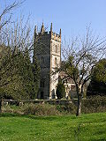
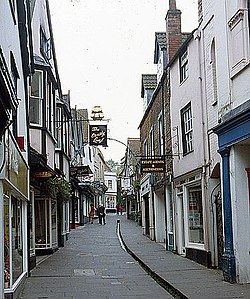
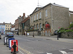
There are 209 Grade II* listed buildings in Mendip. The list includes a large number of churches, some of which are Norman. Several buildings are associated with the church, particularly the Anglican Glastonbury Abbey and Wells Cathedral along with the Benedictine Downside Abbey. Many of the rest of the buildings are urban or rural houses ranging in date from the 12th to 19th centuries. Trade in the area is represented by market crosses and the Anglo-Bavarian Brewery. Shepton Mallet Prison and a village lock-up are also included in the list. The oldest is the Church of St Mary, Laverton, while the most recent is Mells War Memorial by Sir Edwin Lutyens.
East Harptree is a village and civil parish in Somerset, England. It is situated 5 miles (8.0 km) north of Wells and 15 miles (24.1 km) south of Bristol, on the northern slope of the Mendip Hills overlooking the Chew Valley. The parish has a population of 644. The parish includes the hamlet of Coley.
The Grade I listed buildings in Somerset, England, demonstrate the history and diversity of its architecture. The ceremonial county of Somerset consists of a non-metropolitan county, administered by Somerset County Council, which is divided into five districts, and two unitary authorities. The districts of Somerset are West Somerset, South Somerset, Taunton Deane, Mendip and Sedgemoor. The two administratively independent unitary authorities, which were established on 1 April 1996 following the breakup of the county of Avon, are North Somerset and Bath and North East Somerset. These unitary authorities include areas that were once part of Somerset before the creation of Avon in 1974.
Mendip is a local government district in the English county of Somerset. The Mendip district covers a largely rural area of 285 square miles (738 km2) ranging from the Mendip Hills through on to the Somerset Levels. It has a population of approximately 11,000. The administrative centre of the district is Shepton Mallet.
Sedgemoor is a local government district in the English county of Somerset. In the United Kingdom, the term listed building refers to a building or other structure officially designated as being of special architectural, historical or cultural significance; Grade I structures are those considered to be "buildings of exceptional interest". Listing was begun by a provision in the Town and Country Planning Act 1947. Once listed, severe restrictions are imposed on the modifications allowed to a building's structure or its fittings. In England, the authority for listing under the Planning Act 1990 rests with Historic England, a non-departmental public body sponsored by the Department for Digital, Culture, Media and Sport; local authorities have a responsibility to regulate and enforce the planning regulations.
The Vale of Glamorgan has 740 listed buildings of which 4% are Grade I listed, 10% Grade II* listed and remainder Grade II listed.
West Somerset is a local government district in the county of Somerset which is in South West England. In the United Kingdom, the term listed building refers to a building or other structure officially designated as being of special architectural, historical or cultural significance; Grade II* structures are those considered to be "particularly significant buildings of more than local interest". Listing was begun by a provision in the Town and Country Planning Act 1947. Once listed, severe restrictions are imposed on the modifications allowed to a building's structure or its fittings. In England, the authority for listing under the Planning Act 1990 rests with Historic England, a non-departmental public body sponsored by the Department for Digital, Culture, Media and Sport; local authorities have a responsibility to regulate and enforce the planning regulations.
North Somerset is a unitary authority in the ceremonial county of Somerset, England. As a unitary authority, North Somerset is administered independently of the non-metropolitan county of Somerset. Its administrative headquarters are located in the town hall of Weston-super-Mare.
Sedgemoor is a local government district in the English county of Somerset. In the United Kingdom, the term listed building refers to a building or other structure officially designated as being of special architectural, historical or cultural significance; Grade II* structures are those considered to be "particularly significant buildings of more than local interest". Listing was begun by a provision in the Town and Country Planning Act 1947. Once listed, severe restrictions are imposed on the modifications allowed to a building's structure or its fittings. In England, the authority for listing under the Planning Act 1990 rests with Historic England, a non-departmental public body sponsored by the Department for Digital, Culture, Media and Sport; local authorities have a responsibility to regulate and enforce the planning regulations.
South Somerset is a local government district in the English county of Somerset. The South Somerset district occupies an area of 370 square miles (958 km2), stretching from its borders with Devon and Dorset to the edge of the Somerset Levels. The district has a population of about 158,000, and has Yeovil as its administrative centre.
Taunton Deane is a local government district with borough status in the English county of Somerset. In the United Kingdom, the term listed building refers to a building or other structure officially designated as being of special architectural, historical or cultural significance; Grade II* structures are those considered to be "particularly significant buildings of more than local interest". Listing was begun by a provision in the Town and Country Planning Act 1947. Once listed, severe restrictions are imposed on the modifications allowed to a building's structure or its fittings. In England, the authority for listing under the Planning Act 1990 rests with Historic England, a non-departmental public body sponsored by the Department for Digital, Culture, Media and Sport; local authorities have a responsibility to regulate and enforce the planning regulations.
In the United Kingdom, the term listed building refers to a building or other structure officially designated as being of special architectural, historical, or cultural significance; Grade II* structures are those considered to be "particularly important buildings of more than special interest". Listing was begun by a provision in the Town and Country Planning Act 1947. Once listed, strict limitations are imposed on the modifications allowed to a building's structure or fittings. In Wales, the authority for listing under the Planning Act 1990 rests with Cadw.
Nether Alderley is a civil parish in Cheshire East, England. It contains 56 buildings that are recorded in the National Heritage List for England as designated listed buildings. Of these, one is listed at Grade I, the highest grade, four are listed at Grade II*, the middle grade, and the others are at Grade II. The parish contains the village of Nether Alderley. The largest house in the parish was the Old Hall which was damaged by fire in 1779. This was replaced on a different site by Park House in Alderley Park. This was in turn damaged by fire in 1931, and was demolished in 1933. Much of the park has since been used by a major pharmaceutical company.
St Bees is a civil parish in the Borough of Copeland, Cumbria, England. It contains 38 buildings that are recorded in the National Heritage List for England. Of these, four are listed at Grade I, the highest of the three grades, two are at Grade II*, the middle grade, and the others are at Grade II, the lowest grade. The parish includes the village of St Bees and the surrounding coastline and countryside. In the 12th century a Benedictine priory was established in the parish. Most of this disappeared after the Dissolution of the Monasteries apart from the priory church, most of which became the Church of St Mary and St Bega, the parish church of the village, while most of the chancel was modified for other uses. Also in the village is St Bees School, an independent school. The church, the school, and a number of associated structures are listed. Most of the other listed buildings are houses and associated structures, and farmhouses and farm buildings. The other listed buildings include a bridge, a signal box, and two war memorials.
Alberbury with Cardeston is a civil parish in Shropshire, England. It contains 58 listed buildings that are recorded in the National Heritage List for England. Of these, one is listed at Grade I, the highest of the three grades, seven are at Grade II*, the middle grade, and the others are at Grade II, the lowest grade. The parish contains the villages and settlements of Alberbury, Cardeston, Wollaston, Halfway House, and Rowton, and is otherwise rural. In the parish the listed buildings include two ruined castles, two country houses and associated structures including lodges, and three churches and items in the churchyards. Most of the other listed buildings are houses, cottages, farmhouses and farm buildings, and the rest include the remains of a windmill, two milestones, a public house, and a war memorial. Three of the listed buildings are also Scheduled Monuments.
Pimhill is a civil parish in Shropshire, England. It contains 67 listed buildings that are recorded in the National Heritage List for England. Of these, twelve are at Grade II*, the middle of the three grades, and the others are at Grade II, the lowest grade. The parish is to the northwest of Shrewsbury, it contains the villages of Albrighton, Atcham, Fitz, Leaton, Merrington and Preston Gubbals and smaller settlements, and is otherwise rural. In the parish are a former manor house and seven country houses that are listed, together with structures associated with them. Otherwise, most of the listed buildings are smaller houses, cottages, farmhouses and farm buildings, the older of which are timber framed, or have timber-framed cores. The other listed buildings include churches and items in the churchyards, a private chapel, a group of almshouses, an eyecatcher, a war memorial, and five mileposts,
Lapley, Stretton and Wheaton Aston is a civil parish in the district of South Staffordshire, Staffordshire, England. It contains 54 listed buildings that are recorded in the National Heritage List for England. Of these, one is listed at Grade I, the highest of the three grades, four are at Grade II*, the middle grade, and the others are at Grade II, the lowest grade. The parish contains the villages of Lapley, Stretton, and Wheaton Aston, and the surrounding countryside. Most of the listed buildings are houses and associated structures, cottages. farmhouses, and farm buildings, the earlier of which are timber framed or have a timber framed core. The Shropshire Union Canal passes through the parish, and the listed buildings associated with this are bridges, aqueducts and a milepost. The other listed buildings include churches and items in the churchyards, country houses and associated structures, and a former watermill.
Pattingham and Patshull is a civil parish in the district of South Staffordshire, Staffordshire, England. It contains 48 listed buildings that are recorded in the National Heritage List for England. Of these, two are listed at Grade I, the highest of the three grades, six are at Grade II*, the middle grade, and the others are at Grade II, the lowest grade. The parish contains the villages of Pattingham and Burnhill Green and the surrounding area. A large part of the parish is occupied by Patshull Park, the estate of Patshull Hall. The hall is listed, together with associated structures and items in the park. The other listed buildings include houses and cottages, farmhouses and farm buildings, churches and associated structures, including memorials in the churchyard, a public house, a former eel trap, a windmill converted into a house, and a memorial hall.
As of February 2001, there were 1,124 listed buildings with Grade II status in the English city of Brighton and Hove. The total at 2009 was similar. The city, on the English Channel coast approximately 52 miles (84 km) south of London, was formed as a unitary authority in 1997 by the merger of the neighbouring towns of Brighton and Hove. Queen Elizabeth II granted city status in 2000.
Bingley is a civil parish in the metropolitan borough of the City of Bradford, West Yorkshire, England. It contains 102 listed buildings that are recorded in the National Heritage List for England. Of these, one is listed at Grade I, the highest of the three grades, six are at Grade II*, the middle grade, and the others are at Grade II, the lowest grade. The parish contains the town of Bingley and the surrounding countryside to the north, east and south, including the villages and settlements of Cottingley, Eldwick, Gilstead, and Micklethwaite.