Witham Friary

Last updated

Witham Friary
Witham Friary church and cottages.jpg
Somerset UK location map.svg
Red pog.svg
Witham Friary
Location within Somerset
Population399 (2011) [1]
OS grid reference ST745409
Unitary authority
Ceremonial county
Region
Country England
Sovereign state United Kingdom
Post town FROME
Postcode district BA11
Dialling code 01373
Police Avon and Somerset
Fire Devon and Somerset
Ambulance South Western
UK Parliament
List of places
UK
England
Somerset
51°10′08″N2°21′58″W / 51.169°N 2.366°W / 51.169; -2.366

Witham Friary is a small English village and civil parish located between the towns of Frome and Bruton in the county of Somerset. It is in the Cranborne Chase and West Wiltshire Downs Area of Outstanding Natural Beauty and the ancient Forest of Selwood.

Contents

History

The parish was part of the hundred of Frome. [2]

The village takes its name from a technically confused reference (a friary is generally a house of Franciscans and in any case not of Carthusians) to the Witham Charterhouse, a Carthusian Priory founded in 1182 by Henry II, [3] which had peripheral settlements including one at Charterhouse and possibly another at Green Ore. [4] It is reputed to be the first Carthusian house in England. [5] One of only nine Carthusian Houses in the country, the priory did not survive the Dissolution of the Monasteries. [6] At the Dissolution it was worth £227; the equivalent of £52,000 today (2006). [7] Excavations in 1921 revealed buttressed wall foundations and building rubble including glazed roof and floor tiles. It is a scheduled ancient monument. [4]

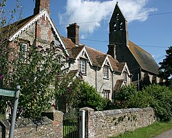
Part of the priory now serves as St Mary's Parish Church. [8] Although the original building dates from around 1200 it was altered in a transitional style in 1828, and then rebuilt and extended 1875 by William White in "Muscular Gothic" style. It has a three-bay nave and continuous one bay apsidal chancel, built of local limestone rubble, supported on each side by four massive flying buttresses. The plastered interior is entered through a Norman style doorway. Inside the church is a scraped octagonal font dating from around 1450. The Jacobean pulpit contains medieval work and there is a royal arms of 1660 at the west end. The stained glass windows contain fragments of medieval glass, with the windows in the south being made by Sir Ninian Comper. It has been designated by English Heritage as a Grade I listed building. [9]

The former Village Reading Rooms are in a thirteenth-century building which was once a dovecote associated with the Priory. They are grade II* listed building [10] but are included on Mendip District Council Historic Buildings at Risk Register. [11]

The village has older roots. A wealth of nearby tumuli is indicative of ancient human settlement. An archaeological dig in 1985 discovered a neolithic axe and a Roman road. [6] The village is mentioned in the Domesday Book of 1086, when it supported 11 villagers. [6]

The former railway station at Witham was the end of a branch line through Shepton Mallet, Wells and Cheddar. The station closed in 1963 although the main line to Exeter remains open. The nearest railway station is Bruton. Part of the redundant line that ran to Shepton Mallet now forms the East Somerset Railway. [12]

Governance

The parish council has responsibility for local issues, including setting an annual precept (local rate) to cover the council’s operating costs and producing annual accounts for public scrutiny. The parish council evaluates local planning applications and works with the local police, district council officers, and neighbourhood watch groups on matters of crime, security, and traffic. The parish council's role also includes initiating projects for the maintenance and repair of parish facilities, as well as consulting with the district council on the maintenance, repair, and improvement of highways, drainage, footpaths, public transport, and street cleaning. Conservation matters (including trees and listed buildings) and environmental issues are also the responsibility of the council.

For local government purposes, since 1 April 2023, the village comes under the unitary authority of Somerset Council. Prior to this, it was part of the non-metropolitan district of Mendip, which was formed on 1 April 1974 under the Local Government Act 1972, having previously been part of Frome Rural District. [13]

It is also part of the Somerton and Frome county constituency represented in the House of Commons of the Parliament of the United Kingdom. It elects one Member of Parliament (MP) by the first past the post system of election.

Public House

Coat of arms of the Duke of Somerset Duke of Somerset coa.png
Coat of arms of the Duke of Somerset

The Seymour Arms is a traditional public house. Purpose-built along with farm buildings in 1866 or 1867 for the Duke of Somerset's estate, it takes its name from the family name of the Duke of Somerset.

The pub is noted by CAMRA because of its beautifully preserved interior, and is included in their National Inventory of Historic Pubs. [14]

Water Dispute

Since the 19th century, the village water supply has come from the estate of the Duke of Somerset rather than from a commercial water company. The estate's decision to terminate the supply is a cause for local concern. [15] [16]

Geography and Geology

The village lies near the source of the River Frome and at 96 metres above sea level. There is a risk of flooding. [17] The underlying solid geology is Middle Jurassic Cornbrash.

Building the Dream

In 2004 the village hosted a reality television programme broadcast on Channel 4 called Building the Dream, hosted by Linda Barker. Couples competed to win a dream home in the village. [18] A local production company, Zeal, was responsible. [19]

Related Research Articles

<span class="mw-page-title-main">Mendip District</span> Former non-metropolitan district in England

Mendip was a local government district of Somerset in England. The district covered a largely rural area of 285 square miles (738 km2) with a population of approximately 112,500, ranging from the Wiltshire border in the east to part of the Somerset Levels in the west. The district took its name from the Mendip Hills. The administrative centre of the district was Shepton Mallet but the largest town was Frome.

<span class="mw-page-title-main">Bruton</span> Town in Somerset, England

Bruton is a market town, electoral ward, and civil parish in Somerset, England, on the River Brue and the A359 between Frome and Yeovil. It is 7 miles (11 km) south-east of Shepton Mallet, just south of Snakelake Hill and Coombe Hill, 10 miles (16 km) north-west of Gillingham and 12 miles (19 km) south-west of Frome. The town and ward have a population of 2,907. The parish includes the hamlets of Wyke Champflower and Redlynch. Bruton has a museum of items from the Jurassic era onwards.

<span class="mw-page-title-main">Norton St Philip</span> Human settlement in Somerset, England

Norton St Philip is a village and civil parish in Somerset, England. The village lies about 5+12 miles (9 km) south of the city of Bath and 5 miles (8 km) north of the town of Frome on the eastern slopes of the Mendip Hills. It is situated on the A366 between Trowbridge and Radstock, and on the B3110 between Bath and Frome.

<span class="mw-page-title-main">Westbury-sub-Mendip</span> Human settlement in England

Westbury-sub-Mendip is a village in Somerset, England, on the southern slopes of the Mendip Hills 4 miles (6.4 km) from Wells and Cheddar.

<span class="mw-page-title-main">Charterhouse, Somerset</span> Human settlement in England

Charterhouse, also known as Charterhouse-on-Mendip, is a hamlet and former civil parish, now in the parish of Priddy, in the Mendip Hills Area of Outstanding Natural Beauty (AONB) in the Somerset district, in the ceremonial county of Somerset, England. The area between Charterhouse and Cheddar Gorge including Velvet Bottom and Ubley Warren is covered by the Cheddar Complex Site of Special Scientific Interest. In 1931 the parish had a population of 68.

<span class="mw-page-title-main">Cranmore, Somerset</span> Human settlement in England

Cranmore is a village and civil parish east of Shepton Mallet, in the Mendip district of Somerset, England. The parish includes the hamlets of Waterlip, East Cranmore and Dean.

<span class="mw-page-title-main">Ditcheat</span> Human settlement in England

Ditcheat is a village and civil parish 4.5 miles (7 km) south of Shepton Mallet, and 2.5 miles (4 km) north-west of Castle Cary, in Somerset, England. Besides the village, the parish has four hamlets: Wraxall, Lower Wraxall, Alhampton and Sutton.

<span class="mw-page-title-main">Downhead</span> Human settlement in England

Downhead is a village and civil parish close to Leigh-on-Mendip and 5 miles (8 km) north east of Shepton Mallet, in the Mendip district of Somerset, England. The parish includes the medieval settlement of Tadhill.

<span class="mw-page-title-main">Evercreech</span> Human settlement in England

Evercreech is a village and civil parish in Somerset, England. The village is 3 miles (4.8 km) southeast of Shepton Mallet, and 5 miles (8.0 km) northeast of Castle Cary. The parish includes the hamlet of Stoney Stratton and the village of Chesterblade.

<span class="mw-page-title-main">Lullington, Somerset</span> Human settlement in England

Lullington is a village and civil parish just across the Mells River from Beckington and 2.5 miles (4.0 km) north east of Frome, in the Mendip district of Somerset, England.

<span class="mw-page-title-main">Milton Clevedon</span> Human settlement in England

Milton Clevedon is a village and civil parish 1 mile (1.6 km) south of Evercreech in the Mendip district of Somerset, England.

<span class="mw-page-title-main">Pylle</span> Human settlement in England

Pylle is a village and civil parish 4 miles (6.4 km) south west of Shepton Mallet, and 7 miles (11.3 km) from Wells, in the Mendip district of Somerset, England. It has a population of 160. The parish includes the hamlet of Street on the Fosse.

<span class="mw-page-title-main">Stoke St Michael</span> Village and civil parish in England

Stoke St Michael is a village and civil parish on the Mendip Hills 4 miles (6.4 km) north east of Shepton Mallet, and 8 miles (12.9 km) west of Frome, in the Mendip district of Somerset, England.

<span class="mw-page-title-main">Wanstrow</span> Human settlement in England

Wanstrow is a village and civil parish 6 miles (9.7 km) south west of Frome in Somerset, England. The parish includes the village of Cloford.

<span class="mw-page-title-main">Friary, Somerset</span> Human settlement in England

The Friary is a small hamlet outside the English village of Freshford, about 6 miles (10 km) south of Bath, Somerset. Although closer to Freshford it lies within the parish of Hinton Charterhouse.

<span class="mw-page-title-main">Witham Charterhouse</span>

Witham Charterhouse, also Witham Priory, at Witham Friary, Somerset, was established in 1178/79, the earliest of the ten medieval Carthusian houses (charterhouses) in England. It was suppressed in the Dissolution of the Monasteries in 1539.

<span class="mw-page-title-main">Hinton Priory</span> Monastery in Somerset, England

Hinton Priory was a Carthusian monastery in northeast Somerset, England, from 1232 until 1539.

<span class="mw-page-title-main">Church of St Mary, Witham Friary</span> Church in Somerset, England

The Church of St Mary in Witham Friary, Somerset, England, dates from around 1200 and it has been designated as a Grade I listed building.

<span class="mw-page-title-main">Leigh-on-Mendip</span> Human settlement in England

Leigh-on-Mendip or Leigh upon Mendip is a small village on the Mendip Hills in Somerset, England. It lies roughly equidistant from Frome, Radstock and Shepton Mallet at about 5 miles (8 km) from each town.

References

  1. "Witham Friary Parish". Neighbourhood Statistics. Office for National Statistics. Retrieved 1 January 2014.
  2. "Somerset Hundreds". GENUKI. Retrieved 8 October 2011.
  3. "Witham Friary Somerset". A Vision of Britain through time. Retrieved 15 December 2015.
  4. 1 2 Reid, Robert Douglas (1979). Some buildings of Mendip. The Mendip Society. ISBN   0-905459-16-4.
  5. "Witham-Friary (St Mary)". British History Online. Retrieved 2 September 2007.
  6. 1 2 3 "Land adjoining Gramarye, Witham Friary, Somerset" (PDF). Context One Archaeological Services. Archived from the original (PDF) on 20 August 2007. Retrieved 2 September 2007.
  7. "Purchasing Power of British Pounds from 1264 to 2006". Measuring worth.com. Retrieved 2 September 2007.
  8. "Local History — Witham Friary". Somerset Larders.com. Retrieved 2 September 2007.
  9. Historic England. "Church of St Mary (1058224)". National Heritage List for England . Retrieved 2 September 2007.
  10. Historic England. "Former Village Reading Room, Witham Friary (1175244)". National Heritage List for England . Retrieved 5 September 2016.
  11. "Historic Buildings at Risk Register". Mendip District Council. p. Entry 44. Retrieved 5 September 2016.
  12. "History of the ESR". East Somerset Railway. Archived from the original on 8 October 2007. Retrieved 2 September 2007.
  13. "Frome RD". A vision of Britain Through Time. University of Portsmouth. Retrieved 4 January 2014.
  14. "South West England". CAMRA National Inventory of Heritage Pubs. Retrieved 2 September 2007.
  15. Morris, Steven (31 May 2006). "Village left high and dry by lord of manor". The Guardian. Retrieved 2 September 2007.
  16. "Water Supply to the village of Witham Friary". Mendip District Council. Archived from the original on 27 September 2007. Retrieved 2 September 2007.
  17. "Somerset Frome from Witham Friary to Frome". Environment Agency Flood Warning. Retrieved 4 October 2010.
  18. "UK Game Shows" . Retrieved 28 August 2007.
  19. "Zeal TV" . Retrieved 28 August 2007.