Coleford, Somerset

Last updated

Coleford
Colefordchurch.jpg
Holy Trinity Church
Somerset UK location map.svg
Red pog.svg
Coleford
Location within Somerset
Population2,313 (2011) [1]
OS grid reference ST685495
Unitary authority
Ceremonial county
Region
Country England
Sovereign state United Kingdom
Post town RADSTOCK
Postcode district BA3
Dialling code 01373
Police Avon and Somerset
Fire Devon and Somerset
Ambulance South Western
UK Parliament
List of places
UK
England
Somerset
51°14′39″N2°27′07″W / 51.2442°N 2.4519°W / 51.2442; -2.4519

Coleford is a village and civil parish in Somerset, England, situated on the Mells River in the Mendip Hills five miles west of Frome. The parish has a population of 2,313 in 2011. [1]

Contents

History

Coleford was listed in the Domesday Book of 1086 as Colford, meaning the hill ford, possibly from the Old French col and ford, or alternatively the coal ford, a ford over which charcoal was carried. [2] [3]

There are visible remains of a famous unfinished engineering project, the Dorset and Somerset Canal aqueduct, known locally as the 'Huckyduck', which was abandoned in 1803. [4]

The village once had several coal mines as part of the now closed Somerset coalfield. Just north of Coleford there were the collieries of Newbury and Mackintosh. Mackintosh opened in 1867 but closed in 1919, due to flooding. [5] The Natural Stone Products factory is built on the site of Newbury Colliery. This pit started around the beginning of the 19th century and closed in 1927. [5] The Coal Barton mine was the scene of a firedamp explosion which killed nine miners in 1869. [5]

Governance

The parish council has responsibility for local issues, including setting an annual precept (local rate) to cover the council's operating costs and producing annual accounts for public scrutiny. The parish council evaluates local planning applications and works with the local police, district council officers, and neighbourhood watch groups on matters of crime, security, and traffic. The parish council's role also includes initiating projects for the maintenance and repair of parish facilities, as well as consulting with the district council on the maintenance, repair, and improvement of highways, drainage, footpaths, public transport, and street cleaning. Conservation matters (including trees and listed buildings) and environmental issues are also the responsibility of the council.

The village falls within the Non-metropolitan district of Mendip, which was formed on 1 April 1974 under the Local Government Act 1972, having previously been part of Frome Rural District, [6] which is responsible for local planning and building control, local roads, council housing, environmental health, markets and fairs, refuse collection and recycling, cemeteries and crematoria, leisure services, parks, and tourism.

Somerset County Council is responsible for running the largest and most expensive local services such as education, social services, libraries, main roads, public transport, policing and fire services, trading standards, waste disposal and strategic planning.

The village falls within the 'Coleford and Holcombe' electoral Ward. The ward stretches in the east from Coleford before going west to Holcombe and then south west to Stoke St. Michael. Mells is also included. The total ward population as at the 2011 census was 4,700. [7]

It is also part of the Somerton and Frome county constituency represented in the House of Commons of the Parliament of the United Kingdom. It elects one Member of Parliament (MP) by the first past the post system of election, and was part of the South West England constituency of the European Parliament prior to Britain leaving the European Union in January 2020, which elected seven MEPs using the d'Hondt method of party-list proportional representation.

Religious sites

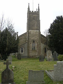
The Anglican Parish Church of The Holy Trinity was built in 1831 by J. Sperring. [8] The Methodist Chapel is a little more recent having been built in 1865. [9]

Related Research Articles

<span class="mw-page-title-main">Dorset and Somerset Canal</span> Partially-built and abandoned canal in South-West England

The Dorset and Somerset Canal was a proposed canal in southwestern England. The main line was intended to link Poole, Dorset with the Kennet and Avon Canal near Bradford on Avon, Wiltshire. A branch was to go from the main line at Frome to the southern reaches of the Somerset coalfield at Nettlebridge. Construction of the branch started in 1786, using boat lifts rather than locks to cope with changes of level, but the company ran out of money and the canal was abandoned in 1803, never to be completed.

<span class="mw-page-title-main">Mendip District</span> Former non-metropolitan district in England

Mendip was a local government district of Somerset in England. The district covered a largely rural area of 285 square miles (738 km2) with a population of approximately 112,500, ranging from the Wiltshire border in the east to part of the Somerset Levels in the west. The district took its name from the Mendip Hills. The administrative centre of the district was Shepton Mallet but the largest town was Frome.

<span class="mw-page-title-main">Radstock</span> Human settlement in England

Radstock is a town and civil parish on the northern slope of the Mendip Hills in Somerset, England, about 9 miles (14 km) south-west of Bath and 8 miles (13 km) north-west of Frome. It is within the area of the unitary authority of Bath and North East Somerset. The Radstock built-up area had a population of 9,419 at the 2011 Census.

<span class="mw-page-title-main">Buckland Dinham</span> Human settlement in England

Buckland Dinham is a small village near Frome in Somerset, England. The village has a population of 381. The village's main industry is farming, but the village is also a dormitory village for the nearby cities of Bath and Bristol.

<span class="mw-page-title-main">Pensford</span> Human settlement in England

Pensford is the largest village in the civil parish of Publow in Somerset, England. It lies in the Chew Valley, approximately 7 miles (11 km) south of Bristol, 8 miles (13 km) west of Bath, and 14 miles (23 km) north of Wells. It is on the A37 road from Bristol to Shepton Mallet.

<span class="mw-page-title-main">Somerton and Frome (UK Parliament constituency)</span> UK Parliamentary constituency

Somerton and Frome is a constituency in Somerset represented in the House of Commons of the UK Parliament since 2023 by Sarah Dyke of the Liberal Democrats.

<span class="mw-page-title-main">Holcombe, Somerset</span> Human settlement in England

Holcombe is a small village and civil parish in the Mendip local government district of Somerset, England. The parish contains the hamlets of Barlake and Edford. It is within easy commuting distance of both Bristol and Bath.

<span class="mw-page-title-main">Whatley, Mendip</span> Human settlement in England

Whatley is a small rural village and civil parish about 2.5 miles (4 km) west of Frome in the English county of Somerset. The parish lies south of Mells and north of Nunney, and includes the hamlets of Lower Whatley and Chantry.

<span class="mw-page-title-main">Kilmersdon</span> Human settlement in England

Kilmersdon is a village and civil parish on the north eastern slopes of the Mendip Hills in Somerset between the towns of Radstock and Frome. It is located on the B3139 between Wells and Trowbridge in Wiltshire. The settlement is recorded in William I's Domesday book and dates back at least 1,000 years; though the core of the village dates from the mid nineteenth century. The parish includes the hamlets of Charlton, South View and Green Parlour.

<span class="mw-page-title-main">Rode, Somerset</span> Human settlement in England

Rode is a village and civil parish in the ceremonial county of Somerset in England, 5 miles (8.0 km) north-east of Frome and 5 miles (8.0 km) south-west of Trowbridge.

<span class="mw-page-title-main">Mells, Somerset</span> Village in Somerset, England

Mells is a village and civil parish in Somerset, England, near the town of Frome.

<span class="mw-page-title-main">Stratton-on-the-Fosse</span> Village in Somerset, England

Stratton-on-the-Fosse is a village and civil parish located on the edge of the Mendip Hills, 2 miles (3 km) south-west of Westfield, 6 miles (10 km) north-east of Shepton Mallet, and 9 miles (14 km) from Frome, in Somerset, England. It has a population of 1,108, and has a rural agricultural landscape, although it was part of the once-thriving Somerset coalfield. Within the boundaries of the parish are the hamlets of Benter and Nettlebridge.

<span class="mw-page-title-main">Somerset Coalfield</span> Coalfield in northern Somerset, England

The Somerset Coalfield in northern Somerset, England is an area where coal was mined from the 15th century until 1973. It is part of a larger coalfield which stretched into southern Gloucestershire. The Somerset coalfield stretched from Cromhall in the north to the Mendip Hills in the south, and from Bath in the east to Nailsea in the west, a total area of about 240 square miles (622 km2). Most of the pits on the coalfield were concentrated in the Cam Brook, Wellow Brook and Nettlebridge Valleys and around Radstock and Farrington Gurney. The pits were grouped geographically, with clusters of pits close together working the same coal seams often under the same ownership. Many pits shared the trackways and tramways which connected them to the Somerset Coal Canal or railways for distribution.

<span class="mw-page-title-main">Great Elm</span> Village in Somerset, England

Great Elm is a village and civil parish between Mells and Frome in the Mendip district of Somerset, England. The parish includes the hamlet of Hapsford.

<span class="mw-page-title-main">Hemington, Somerset</span> Human settlement in England

Hemington is a village and civil parish 5.5 miles (8.9 km) north west of Frome, in the Mendip district of Somerset, England. It is located just off the A366 between Trowbridge and Radstock. The parish includes the villages of Hardington, Faulkland and Foxcote.

<span class="mw-page-title-main">Lullington, Somerset</span> Human settlement in England

Lullington is a village and civil parish just across the Mells River from Beckington and 2.5 miles (4.0 km) north east of Frome, in the Mendip district of Somerset, England.

<span class="mw-page-title-main">Selwood, Somerset</span> Human settlement in England

Selwood used to be a village but is now part of the suburbs of Frome. It is a civil parish in the Mendip district of Somerset, England. The parish includes the villages of East and West Woodlands, Rodden and the hamlets of Alder Row and Blatchbridge.

<span class="mw-page-title-main">Stoke St Michael</span> Village and civil parish in England

Stoke St Michael is a village and civil parish on the Mendip Hills 4 miles (6.4 km) north east of Shepton Mallet, and 8 miles (12.9 km) west of Frome, in the Mendip district of Somerset, England.

<span class="mw-page-title-main">Tellisford</span> Human settlement in England

Tellisford is a village and civil parish 6 miles (10 km) north-east of Frome in the Mendip district of Somerset, England. The parish includes the village of Woolverton.

<span class="mw-page-title-main">Leigh-on-Mendip</span> Human settlement in England

Leigh-on-Mendip or Leigh upon Mendip is a small village on the Mendip Hills in Somerset, England. It lies roughly equidistant from Frome, Radstock and Shepton Mallet at about 5 miles (8 km) from each town.

References

  1. 1 2 "Coleford Parish". Neighbourhood Statistics. Office for National Statistics. Retrieved 1 January 2014.
  2. Robinson, Stephen (1992). Somerset Place Names. Wimborne, Dorset: The Dovecote Press Ltd. ISBN   1-874336-03-2.
  3. Atthill, Robin (1976). Mendip: A new study. Newton Abbot, Devon: David & Charles. ISBN   0-7153-7297-1.
  4. Dunning, Robert (1983). A History of Somerset. Chichester: Phillimore & Co. ISBN   0-85033-461-6.
  5. 1 2 3 "Coal Mining". Somerset Ramblers. Archived from the original on 27 October 2009. Retrieved 12 November 2006.
  6. "Frome RD". A vision of Britain Through Time. University of Portsmouth. Retrieved 4 January 2014.
  7. "Coleford and Holcombe ward 2011" . Retrieved 7 March 2015.
  8. Historic England. "Church of The Holy Trinity (1058736)". National Heritage List for England . Retrieved 30 November 2008.
  9. Historic England. "Methodist Chapel (1175643)". National Heritage List for England . Retrieved 30 November 2008.

Commons-logo.svg Media related to Coleford at Wikimedia Commons