
Pilton is a village and civil parish in Somerset, England, situated on the A361 road in the Mendip district, 3 miles (5 km) south-west of Shepton Mallet and 6 miles (10 km) east of Glastonbury. The village has a population of 998. The parish includes the hamlets of West Compton, East Compton, Westholme, Beardly Batch and Cannards Grave.
All Saints' Church, is in Childwall, Liverpool, England. It is recorded in the National Heritage List for England as a designated Grade I listed building, and is the only medieval church remaining in the Metropolitan borough of Liverpool. It is an active Anglican parish church in the diocese of Liverpool, the archdeaconry of Liverpool and the deanery of Liverpool South – Childwall.

Binegar is a small village and civil parish in Somerset, England. It is located on the A37, 4 miles (6.4 km) east of Wells, between Shepton Mallet and Chilcompton. Its population in 2011 was 313. Binegar and Gurney Slade on the opposite side of the A37 are effectively a single village and share a sign on the main road. In Gurney Slade, the quarry and houses on the north side of Tape Lane are in Binegar parish whilst the south side is in Ashwick parish. In Binegar, some houses on the south side of Station Road are in Ashwick parish and some on the north side of the village are in Emborough parish.

Ashwick is a village in the Mendip district of Somerset, England, about three miles north of Shepton Mallet and seven miles east from Wells. It has also been a civil parish since 1826. The parish had a population of 1,352 according to the 2011 census, and apart from Ashwick village also includes Gurney Slade and Oakhill.

Stratton-on-the-Fosse is a village and civil parish located on the edge of the Mendip Hills, 2 miles (3 km) south-west of Westfield, 6 miles (10 km) north-east of Shepton Mallet, and 9 miles (14 km) from Frome, in Somerset, England. It has a population of 1,108, and has a rural agricultural landscape, although it was part of the once-thriving Somerset coalfield. Within the boundaries of the parish are the hamlets of Benter and Nettlebridge.

Cranmore is a village and civil parish east of Shepton Mallet, in the Mendip district of Somerset, England. The parish includes the hamlets of Waterlip, East Cranmore and Dean.

Croscombe is a village and civil parish 2 miles (3 km) west of Shepton Mallet and 4 miles (6 km) from Wells, in the Mendip district of Somerset, England. It is situated on the A371 road in the valley of the River Sheppey.

Downhead is a village and civil parish close to Leigh-on-Mendip and 5 miles (8 km) north east of Shepton Mallet, in the Mendip district of Somerset, England. The parish includes the medieval settlement of Tadhill.

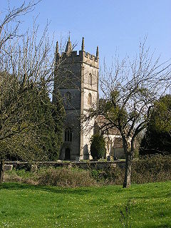
East Pennard is a village and civil parish 4 miles (6.4 km) north west of Castle Cary, and 5 miles (8.0 km) south of Shepton Mallet, in the Mendip district of Somerset, England. It has a population of 348. The parish includes the hamlets of Stone, Parbrook and Huxham.
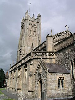
Evercreech is a village and civil parish 3 miles (4.8 km) south east of Shepton Mallet, and 5 miles (8.0 km) north east of Castle Cary, in the Mendip district of Somerset, England. The parish includes the hamlet of Stoney Stratton and the village of Chesterblade.
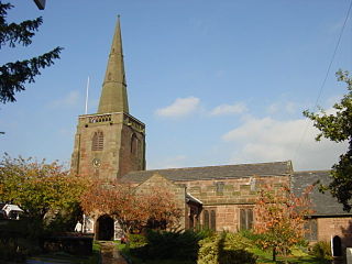
Pylle is a village and civil parish 4 miles (6.4 km) south west of Shepton Mallet, and 7 miles (11.3 km) from Wells, in the Mendip district of Somerset, England. It has a population of 160. The parish includes the hamlet of Street on the Fosse.

West Pennard is a village and civil parish east of Glastonbury, situated at the foot of Pennard Hill, in the Mendip district of Somerset, England. The parish includes the hamlets of Coxbridge and Woodlands.

The parish church of St Michael the Archangel in Dundry, Somerset, England has a tower which was built in 1484, with the rest dated 1861. It has been designated as a Grade I listed building.

The Church of All Saints in Kingston Seymour, Somerset, England dates from the late 14th or early 15th century. It has been designated as a Grade I listed building.

The Church of All Saints in Monksilver, Somerset, England dates from the 12th century and has been designated by English Heritage as a Grade I listed building. The church has a square west tower, built in the 14th century,
The Church of St Gregory in Weare, Somerset, England dates from the 11th century, although most of the building is from the 15th, and has been designated as a grade I listed building.
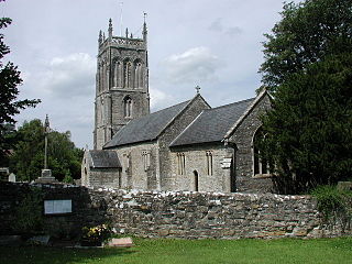
The Church of St Nicholas in West Pennard, Somerset, England, dates from the 15th century and is a Grade I listed building.

The Church of St Matthew in Wookey, Somerset, England, dates from the twelfth century and is a Grade I listed building.

St Helen's Church is an Anglican church in the village of Churchtown in Lancashire, England. Historically, it was the parish church of Garstang; today, as Garstang is split into more than one ecclesiastical parish, St Helen's parish is Garstang St Helen (Churchtown). It is in the Diocese of Blackburn. It has been designated a Grade I listed building by English Heritage. St Helen's is known as the "cathedral of The Fylde".

