Bicknoller

Last updated

Bicknoller
Bicknoller church.jpg
Church of St George, Bicknoller
Somerset UK location map.svg
Red pog.svg
Bicknoller
Location within Somerset
Population371 
OS grid reference ST110396
Civil parish
  • Bicknoller
District
Shire county
Region
Country England
Sovereign state United Kingdom
Post town TAUNTON
Postcode district TA4
Dialling code 01984
Police Avon and Somerset
Fire Devon and Somerset
Ambulance South Western
UK Parliament
List of places
UK
England
Somerset
51°08′57″N3°16′21″W / 51.1491°N 3.2724°W / 51.1491; -3.2724 Coordinates: 51°08′57″N3°16′21″W / 51.1491°N 3.2724°W / 51.1491; -3.2724

Bicknoller is a village and civil parish on the western slopes of the Quantock Hills in the English county of Somerset.

Contents

Administratively, the civil parish falls within the Somerset West and Taunton local government district within the Somerset shire county, with administrative tasks shared between county, district and parish councils. In 2011, the parish had a population of 371. [1]

The village is on the routes of the Coleridge Way and the Macmillan Way West.

History

Above the village lies Trendle Ring, an Iron Age settlement.

The parish of Bicknoller was part of the Williton and Freemanners Hundred. [2]

The village was known in 1291 as Bykenalre which means Bica's alder tree. [3]

From 1430 to 1857 the manor was held by Wells Cathedral. [3]

Governance

The parish council has responsibility for local issues, including setting an annual precept (local rate) to cover the council’s operating costs and producing annual accounts for public scrutiny. The parish council evaluates local planning applications and works with the local police, district council officers, and neighbourhood watch groups on matters of crime, security, and traffic. The parish council's role also includes initiating projects for the maintenance and repair of parish facilities, as well as consulting with the district council on the maintenance, repair, and improvement of highways, drainage, footpaths, public transport, and street cleaning. Conservation matters (including trees and listed buildings) and environmental issues are also the responsibility of the council.
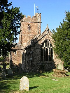
The village falls within the non-metropolitan district of Somerset West and Taunton, which was established on 1 April 2019. It was previously in the district of West Somerset, which was formed on 1 April 1974 under the Local Government Act 1972, and part of Williton Rural District before that. [4] The district council is responsible for local planning and building control, local roads, council housing, environmental health, markets and fairs, refuse collection and recycling, cemeteries and crematoria, leisure services, parks, and tourism.

Somerset County Council is responsible for running the largest and most expensive local services such as education, social services, libraries, main roads, public transport, policing and fire services, trading standards, waste disposal and strategic planning.

It is also part of the Bridgwater and West Somerset county constituency represented in the House of Commons of the Parliament of the United Kingdom. It elects one Member of Parliament (MP) by the first past the post system of election, and was part of the South West England constituency of the European Parliament prior to Britain leaving the European Union in January 2020, which elected seven MEPs using the d'Hondt method of party-list proportional representation.

Religious sites

Part of the Church of St George, a Grade I listed building, [5] dates from the 12th century and is dominated by a huge elm tree in its grounds. The church is decorated with a collection of carved angels and nightmarish animal heads. There is a memorial to William Temple, Archbishop of Canterbury, who spent his holidays in the village from 1933–44. [6]

Landmarks

Although it is closer to the neighbouring village of Halsway, Halsway Manor falls within the parish of Bicknoller. It is a manor house, now used as England's National Centre for Traditional Music, Dance and Song. The eastern end of the building dates from the fifteenth century; the western end is a nineteenth-century addition. [7] The manor, which is mentioned in the Domesday Book, was built by Cardinal Beaufort as a hunting lodge. [8] At one point it was occupied by insurrectionist Jack Cade. [8] Thereafter it was a family home until the mid-1960s, [9] when it became the folk music centre. It has been designated by English Heritage as a Grade II* listed building. [10]

Thorncombe House was built in 1744 by the Sweeting family, but has since had a 19th-century facade added. [3] It is Grade II listed. [11]

Notable people

Bicknoller was the birthplace of the Somerset and England cricketer Harold Gimblett.

Related Research Articles

West Somerset Non-metropolitan district in England

West Somerset was a local government district in the English county of Somerset. The council covered a largely rural area, with a population of 34,900 in an area of 740 square kilometres (290 sq mi); it was the least populous non-unitary district in England. According to figures released by the Office for National Statistics in 2009, the population of West Somerset has the oldest average age in the United Kingdom at 52. The largest centres of population are the coastal towns of Minehead and Watchet (4,400).

Kingston St Mary Human settlement in England

Kingston St Mary is a village and parish in Somerset, England, situated at the southern end of the Quantock Hills 4 miles (6.4 km) north of Taunton in the Somerset West and Taunton district. The village has a population of 921.

Tolland, Somerset Human settlement in England

Tolland is a village and civil parish in Somerset, England, situated 9 miles (14.5 km) north west of Taunton, between the Brendon Hills and Quantock Hills, in the Somerset West and Taunton district. The parish has a population of 81.

Williton Human settlement in England

Williton is a large village and civil parish in Somerset, England, at the junction of the A39, A358 and B3191 roads, on the coast 2 miles (3.2 km) south of Watchet between Minehead, Bridgwater and Taunton in the Somerset West and Taunton district.

Brompton Ralph Human settlement in England

Brompton Ralph is a village and civil parish in the Somerset West and Taunton district of Somerset, England, about 11 miles (18 km) west of Taunton, and 3 miles (5 km) north of Wiveliscombe. It is in a wooded district at the eastern extremity of the Brendon Hills. According to the 2002 population estimates it had a population of 287.

Brompton Regis Human settlement in England

Brompton Regis is a village and civil parish in the Somerset West and Taunton district of Somerset, England about 5 miles (8.0 km) north-east of Dulverton. It is situated on the River Pulham in the Brendon Hills within the Exmoor National Park, close to Wimbleball Lake, a water supply reservoir constructed in the 1970s and completed in 1979. According to the 2011 census the village had a population of 449. The parish boundary is marked by the River Exe which is crossed by the medieval Chilly Bridge and Hele Bridge. The Haddeo is crossed by Bury Bridge.

Stogursey Human settlement in England

Stogursey is the name of a small village and civil parish in the Quantock Hills in Somerset, England. It is situated 3 miles (4.8 km) from Nether Stowey, and 8 miles (12.9 km) west of Bridgwater. The village is situated near the Bristol Channel, which bounds the parish on the north.

Kilve Human settlement in England

Kilve is a village in the Somerset West and Taunton district of Somerset, England, within the Quantock Hills Area of Outstanding Natural Beauty, the first AONB to be established, in 1957.

West Quantoxhead Human settlement in England

West Quantoxhead is a small village and civil parish in the Somerset West and Taunton district of Somerset, England. It lies on the route of the Coleridge Way and on the A39 road at the foot of the Quantock Hills, 3 miles (5 km) from East Quantoxhead, 2.5 miles (4 km) from Williton and equidistant from Bridgwater and Taunton. The parish includes the hamlets of Weacombe and Lower Weacombe.

Sampford Brett Human settlement in England

Sampford Brett is a village and civil parish situated at the south-western edge of the Quantock Hills, Somerset, England, less than 1 mile (1.6 km) south of Williton, just off the A358 road to Taunton.

Stogumber Human settlement in England

Stogumber is a village and civil parish in Somerset, England, on the eastern flank of the Brendon Hills. Besides Stogumber village itself, the parish includes the hamlets of Ashbeer, Capton, Escott, Higher Vexford, Kingswood, Lower Vellow, Lower Vexford, Preston, and Vellow. The village is on the route of the Samaritans Way South West.

Thurloxton Human settlement in England

Thurloxton is a village and civil parish 5 miles (8.0 km) north east of Taunton, and 5 miles (8.0 km) south west of Bridgwater on the south-eastern slopes of the Quantock Hills in the Sedgemoor district of the county of Somerset, in England.

Holford Village in West Somerset, England

Holford is a village and civil parish in West Somerset within the Quantock Hills Area of Outstanding Natural Beauty, and about 10 miles (16 km) west of Bridgwater and 6 miles (10 km) east of Williton. The village has a population of 392. The village is on the Quantock Greenway and Coleridge Way footpaths. The parish includes the village of Dodington.

Crowcombe Human settlement in England

Crowcombe is a village and civil parish under the Quantock Hills in Somerset, England, 5.5 miles (9 km) southeast of Watchet, and 8 miles (13 km) from Taunton. The village has a population of 489.

Stringston Human settlement in England

Stringston is a village and civil parish on the northern edge of the Quantock Hills in the English county of Somerset. The village is 10 miles (16 km) west of Bridgwater, and close to the villages of Holford, Kilve and Stogursey. In 2002, the parish was estimated to have a population of 116.

East Quantoxhead Human settlement in England

East Quantoxhead is a village in the district of Somerset West and Taunton, 3 miles (5 km) from West Quantoxhead, 4 miles (6 km) east of Williton, and 13 miles (21 km) west of Bridgwater, within the Quantock Hills Area of Outstanding Natural Beauty in Somerset, England.

Elworthy Human settlement in England

Elworthy is a small village and civil parish in the Brendon Hills 5 miles (8 km) south-east of Watchet, and 12 miles (19 km) west of Taunton, in the Somerset West and Taunton district of Somerset, England. The parish includes the hamlet of Willett.

Exton, Somerset Human settlement in England

Exton is a village and civil parish 5 miles (8 km) north-east of Dulverton and 9 miles (14 km) south-west of Dunster in Somerset, England. It lies on the River Exe on Exmoor. The parish includes the village of Bridgetown and covers 2,017 ha, all of which is within the National Park.

Treborough Human settlement in England

Treborough is a small village and civil parish 7 miles (11 km) south of Dunster, lying amongst the Brendon Hills within the Exmoor National Park in the Somerset West and Taunton district of Somerset, England.

Nettlecombe, Somerset Human settlement in England

Nettlecombe is a civil parish in the English county of Somerset. The parish covers a rural area below the Brendon Hills, comprising the small hamlets of Beggearn Huish, Torre, WoodfordYarde, together with more isolated individual farms and homes. In 2011, the parish had a population of 174.

References

  1. "Statistics for Wards, LSOAs and Parishes — SUMMARY Profiles" (Excel). Somerset Intelligence. Retrieved 4 January 2014.
  2. "Somerset Hundreds". GENUKI. Retrieved 23 October 2011.
  3. 1 2 3 Bush, Robin (1994). Somerset: The complete guide. Wimborne, Dorset: Dovecote Press. pp.  35–36. ISBN   1-874336-26-1.
  4. "Williton RD". A vision of Britain Through Time. University of Portsmouth. Retrieved 5 January 2014.
  5. Historic England. "Church of St George (1057465)". National Heritage List for England . Retrieved 18 August 2006.
  6. Waite, Vincent (1964). Portrait of the Quantocks. London: Robert Hale. ISBN   0-7091-1158-4.
  7. "History of the Manor". Halsway Manor. Archived from the original on 6 November 2007. Retrieved 2007-11-17.
  8. 1 2 Page, John Lloyd Warden (1895). An Exploration of Exmoor and the Hill Country of West Somerset: With Notes on Its Archaeology. Seeley & Co. Ltd.
  9. "About Halsway Manor". Pictures of England. Archived from the original on 5 November 2007. Retrieved 17 November 2007.
  10. Historic England. "Halsway Manor (1057472)". National Heritage List for England . Retrieved 17 November 2007.
  11. Historic England. "Thorncombe House (1174160)". National Heritage List for England . Retrieved 29 November 2008.