
The Quantock Hills west of Bridgwater in Somerset, England, consist of heathland, oak woodlands, ancient parklands and agricultural land. They were England's first Area of Outstanding Natural Beauty, designated in 1956.

Cadbury Castle is a Bronze and Iron Age hillfort in the civil parish of South Cadbury in the English county of Somerset. It is a scheduled monument and has been associated with King Arthur's legendary court at Camelot.

Dunkery Beacon at the summit of Dunkery Hill is the highest point on Exmoor and in Somerset, England. It is also the highest point in southern England outside of Dartmoor.

West Bagborough is a village and civil parish in Somerset, England, about 5 miles (8.0 km) north of Taunton. In 2011, the village had a population of 358.

Bicknoller is a village and civil parish on the western slopes of the Quantock Hills in the English county of Somerset.

Plainsfield Camp is a possible Iron Age earthwork on the Quantock Hills near Aisholt in Somerset, England.

Ruborough Camp is an Iron Age hill fort on the Quantock Hills near Broomfield in Somerset, England. The name comes from Rugan beorh or Ruwan-beorge meaning Rough Hill. It is a Scheduled Ancient Monument and on the Heritage at Risk Register.
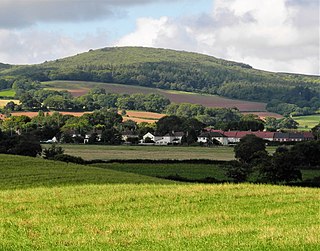
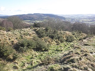
Dowsborough Camp is an Iron Age hill fort on the Quantock Hills near Nether Stowey in Somerset, England. It has been designated as a Scheduled Monument. The fort and associated round barrow has been added to the Heritage at Risk Register due to vulnerability to vehicle damage and erosion.

Bats Castle is an Iron Age hillfort at the top of a 213 metres (699 ft) high hill in the parish of Carhampton south south west of Dunster in Somerset, England.
Bury Castle is an Iron Age hillfort near Selworthy, Somerset, England. It has been designated as a scheduled monument.

Sweetworthy is the site of two Iron Age hill forts or enclosures at Luccombe, 4 kilometres (2 mi) south of Porlock, Somerset, England. They are on the north-facing slope of Dunkery Hill. One has a single rampart and external ditch, enclosing 0.25 hectares. The rampart is still visible and the ditch on the east side is used as a trackway. There was a defended settlement above the main site.

Ladle Hill is a 10.5-hectare (26-acre) biological Site of Special Scientific Interest west of Kingsclere in Hampshire. It is also a Scheduled Monument.

Scratchbury Camp is the site of an Iron Age univallate hillfort on Scratchbury Hill, overlooking the Wylye valley about 1 km northeast of the village of Norton Bavant in Wiltshire, England. The fort covers an area of 37 acres (15 ha) and occupies the summit of the hill on the edge of Salisbury Plain, with its four-sided shape largely following the natural contours of the hill.

Sidbury Hill, or Sidbury Camp, is the site of an Iron Age bivallate hillfort on the eastern edge of Salisbury Plain in Wiltshire, England. The site is sub-triangular in shape, approximately 17 acres (6.9 ha) in area, and is constructed on the site of a Neolithic settlement.
Hillforts in Britain refers to the various hillforts within the island of Great Britain. Although the earliest such constructs fitting this description come from the Neolithic British Isles, with a few also dating to later Bronze Age Britain, British hillforts were primarily constructed during the British Iron Age. Some of these were apparently abandoned in the southern areas that were a part of Roman Britain, although at the same time, those areas of northern Britain that remained free from Roman occupation saw an increase in their construction. Some hillforts were reused in the Early Middle Ages, and in some rarer cases, into the Later Medieval period as well. By the early modern period, these had essentially all been abandoned, with many being excavated by archaeologists in the nineteenth century onward.

Mounsey Castle is an Iron Age irregular triangular earthwork of 1.75 hectares north west of Dulverton, Somerset, England. It has been scheduled as an ancient monument. It has been added to the Heritage at Risk Register.
The term hill-slope enclosure describes a type of late prehistoric earthwork found across South West England and also in Wales. Normally formed from a single bank, or ditch and bank, enclosing an area of less than 1 hectare, and not on the summit of a hill. They are often found on a spur of a larger hill or range of hills.

Beacon Hill, also known as Harting Beacon, is a hillfort on the South Downs, in the county of West Sussex in southern England. The hillfort is located in the parish of Elsted and Treyford, in Chichester District. It is a Scheduled Ancient Monument with a list entry identification number of 1015915. The hilltop enclosure is dated to the Late Bronze Age, from the 8th to 6th centuries BC. The hillfort defences were renewed during the Late Iron Age.
West Somerset was a local government district in the English county of Somerset. It merged with Taunton Deane to form Somerset West and Taunton on 1 April 2019.

