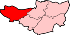
West Somerset

Last updated

West Somerset
West Somerset logo.png
West Somerset UK locator map.svg
Shown within Somerset
Sovereign state United Kingdom
Constituent country England
Region South West England
Ceremonial county Somerset
Admin HQ Williton
Created1 April 1974
Abolished1 April 2019
Government
  Type Non-metropolitan district
  LeaderTim Taylor
  Council 
Area
  Total
280.63 sq mi (726.84 km2)
Population
 (mid-2018)
  Total
34,900
  Density130/sq mi (49/km2)
Time zone UTC0 (GMT)
  Summer (DST) UTC+1 (BST)
Post Code
Area code 01984
Website http://www.westsomersetonline.gov.uk/

West Somerset was a local government district in the English county of Somerset from 1974 to 2019. The council covered a largely rural area, with a population of 34,900 [1] in an area of 740 square kilometres (290 sq mi); [2] it was the least populous non-unitary district in England. According to figures released by the Office for National Statistics in 2009, the population of West Somerset had the oldest average age in the United Kingdom at 52. [3] The largest centres of population were the coastal towns of Minehead (population 10,000) and Watchet (4,400).

Contents

The council's administrative headquarters were located in the village of Williton, with an additional office in Minehead.

In September 2016, West Somerset and Taunton Deane councils agreed in principle to merge the districts into one (with one council) subject to consultation. [4] The new district would not be a unitary authority: it would still be part of the Somerset County Council area. [5] In March 2018 both councils voted in favour of the merger and it came into effect on 1 April 2019, with the first elections to the new council in May 2019. The new authority was known as Somerset West and Taunton Council. [6] [7] [8]

History

The district was formed on 1 April 1974, under the Local Government Act 1972, by a merger of the previous urban districts of Minehead and Watchet, along with Dulverton Rural District and Williton Rural District.

Listed buildings

There were 33 Grade I listed buildings in West Somerset: the oldest are Culbone Church (one of the smallest churches in England, [9] and pre-Norman in origin) [10] and Tarr Steps, which some say originates in the Bronze Age, although others date them from around 1400. [11] Dunster has the greatest concentration of Grade I listed buildings including Dunster Castle, the Yarn Market, Gallox Bridge and Priory Church of St George. Other sites include manor houses such as Nettlecombe Court and Orchard Wyndham. The most recent buildings included in the list are Crowcombe Court which was completed in 1739 [12] and the Church of St John the Baptist in Carhampton which was rebuilt in 1863. [13] There are numerous religious structures in Somerset, with the largest number being Anglican parish churches, dating from Norman or medieval eras. Some of the churches are included in the Somerset towers, a collection of distinctive, mostly spireless Gothic church towers.

West Somerset Council Offices in Williton Williton, West Somerset Council offices - geograph.org.uk - 1551363.jpg
West Somerset Council Offices in Williton

Financial difficulties

In 2012 financial difficulties at the council, including a £1 million reduction over three years, lead to plans to outsource most of the services provided to the population and make most of the staff redundant. [14] It was proposed that some services may be shared with Taunton Deane council. [15] In December 2012 the grant received from central government was increased by 0.9% meaning the council had £3.8million to spend on the provision of services. [16]

Geography

West Somerset benefits from one of the most scenic landscapes in England. Nearly two-thirds of the western land area of the district forms part of Exmoor National Park, designated in 1954, while on the eastern edge of the district are the Quantock Hills, which in 1956 became the first Area of Outstanding Natural Beauty created in the UK. Large areas of Exmoor and the Quantock Hills are also designated as Sites of Special Scientific Interest because of their value for wildlife.

The West Somerset Railway runs through most of the district, from Bishop's Lydeard in the south east to Minehead in the north west. Operated mainly as a tourist attraction, the railway runs mostly steam and some diesel locomotives.

Governance

West Somerset District Council was elected every four years, with 28 councillors being elected at each election. From the first election to the council in 1973 to the 1995 election the council had a majority of independents. Since then the Conservative Party won a majority at the 2003 election, but independents took a majority back at the 2007 election. Following the election in 2011 the Conservatives regained a majority, which they then held until the council's abolition in 2019. [17]

Settlements

Parishes

ImageNameStatusPopulationFormer local authorityCoordinatesRefs
Bicknoller church.jpg Bicknoller Civil parish371 Williton Rural District 51°09′N3°16′W / 51.15°N 3.27°W / 51.15; -3.27 (Bicknoller) [18] [19]
Brompton Ralph church.jpg Brompton Ralph Civil parish287 Williton Rural District 51°05′N3°19′W / 51.08°N 3.31°W / 51.08; -3.31 (Brompton Ralph) [18] [19]
Brompton Regis - geograph.org.uk - 662427.jpg Brompton Regis Civil parish449 Dulverton Rural District 51°04′N3°29′W / 51.07°N 3.49°W / 51.07; -3.49 (Brompton Regis) [18] [20]
BRUSHFORD, Somerset - geograph.org.uk - 66241.jpg Brushford Civil parish519 Dulverton Rural District 51°01′N3°32′W / 51.02°N 3.53°W / 51.02; -3.53 (Brushford, Somerset) [18] [20]
Carhampton, Somerset - geograph.org.uk - 66205.jpg Carhampton Civil parish865 Williton Rural District 51°10′N3°25′W / 51.17°N 3.42°W / 51.17; -3.42 (Carhampton, Somerset) [18] [19]
Clatworthychurch.JPG Clatworthy Civil parish101 Williton Rural District 51°04′N3°21′W / 51.07°N 3.35°W / 51.07; -3.35 (Clatworthy) [19]
Crowcombe church and cross.jpg Crowcombe Civil parish489 Williton Rural District 51°07′N3°14′W / 51.12°N 3.23°W / 51.12; -3.23 (Crowcombe) [18] [19]
Cutcombe church.jpg Cutcombe Civil parish361 Williton Rural District 51°08′N3°32′W / 51.14°N 3.53°W / 51.14; -3.53 (Cutcombe) [18] [19]
Dulverton church.jpg Dulverton Town1,408 Dulverton Rural District 51°03′N3°33′W / 51.05°N 3.55°W / 51.05; -3.55 (Dulverton) [18] [20]
Dunster.jpg Dunster Civil parish817 Williton Rural District 51°11′N3°27′W / 51.18°N 3.45°W / 51.18; -3.45 (Dunster) [18]
East Quantoxhead Church from the SSW - geograph.org.uk - 22698.jpg East Quantoxhead Civil parish104 Williton Rural District 51°11′N3°14′W / 51.18°N 3.24°W / 51.18; -3.24 (East Quantoxhead) [18]
Elworthy church.jpg Elworthy Civil parish103 Williton Rural District 51°07′N3°19′W / 51.11°N 3.31°W / 51.11; -3.31 (Elworthy) [19]
Exfordchurch.jpg Exford Civil parish405 Dulverton Rural District 51°08′N3°38′W / 51.13°N 3.64°W / 51.13; -3.64 (Exford, Somerset) [18] [20]
Fortescuecairn.jpg Exmoor Civil parish251 Dulverton Rural District 51°08′N3°45′W / 51.14°N 3.75°W / 51.14; -3.75 (Exmoor civil parish) [18] [20]
Exton - Bridgetown Mill - geograph.org.uk - 71109.jpg Exton Civil parish243 Dulverton Rural District 51°05′N3°32′W / 51.09°N 3.54°W / 51.09; -3.54 (Exton, Somerset) [18] [20]
Holford.jpg Holford Civil parish392 Williton Rural District 51°10′N3°13′W / 51.16°N 3.21°W / 51.16; -3.21 (Holford) [18] [19]
Huishchampflowerchurch.jpg Huish Champflower Civil parish301 Dulverton Rural District 51°04′N3°22′W / 51.06°N 3.36°W / 51.06; -3.36 (Huish Champflower) [18] [20]
Kilvechantry.jpg Kilve Civil parish305 Williton Rural District 51°11′N3°13′W / 51.18°N 3.22°W / 51.18; -3.22 (Kilve) [18] [19]
Luccombe church.jpg Luccombe Civil parish157 Williton Rural District 51°11′N3°34′W / 51.19°N 3.56°W / 51.19; -3.56 (Luccombe, Somerset) [18] [19]
River Washford, Pooltown.jpg Luxborough Civil parish237 Williton Rural District 51°08′N3°28′W / 51.13°N 3.46°W / 51.13; -3.46 (Luxborough) [18] [19]
View Over Minehead From Hill.jpg Minehead Town11,981 Williton Rural District
Minehead Urban District
51°12′N3°28′W / 51.20°N 3.47°W / 51.20; -3.47 (Minehead) [18] [19] [21]
Bratton Court.jpg Minehead Without Civil parish60 Williton Rural District 51°12′N3°31′W / 51.20°N 3.51°W / 51.20; -3.51 (Minehead Without) [19]
Monksilverchurch.jpg Monksilver Civil parish113 Williton Rural District 51°08′N3°20′W / 51.13°N 3.33°W / 51.13; -3.33 (Monksilver) [18] [19]
NETTLECOMBE, Somerset - geograph.org.uk - 66189.jpg Nettlecombe Civil parish174 Williton Rural District 51°08′N3°21′W / 51.13°N 3.35°W / 51.13; -3.35 (Nettlecombe, Somerset) [18] [19]
Robber's Bridge, Exmoor, Somerset.jpg Oare Civil parish68 Williton Rural District 51°12′N3°43′W / 51.20°N 3.71°W / 51.20; -3.71 (Oare, Somerset) [19]
Old Cleeve church.jpg Old Cleeve Civil parish1,672 Williton Rural District 51°10′N3°23′W / 51.17°N 3.38°W / 51.17; -3.38 (Old Cleeve) [18] [19]
Porlock church.jpg Porlock Civil parish1,440 Williton Rural District 51°13′N3°36′W / 51.21°N 3.60°W / 51.21; -3.60 (Porlock) [18] [19]
Sampford Breet church.jpg Sampford Brett Civil parish270 Williton Rural District 51°10′N3°19′W / 51.16°N 3.31°W / 51.16; -3.31 (Sampford Brett) [18] [19]
Selworthytevillage.jpg Selworthy Civil parish477 Williton Rural District 51°13′N3°33′W / 51.21°N 3.55°W / 51.21; -3.55 (Selworthy) [18] [19]
St John the Baptist, Skilgate - geograph.org.uk - 693728.jpg Skilgate Civil parish100 Dulverton Rural District 51°02′N3°27′W / 51.04°N 3.45°W / 51.04; -3.45 (Skilgate) [20]
Crowcombe Heathfield railway station signal box.jpg Stogumber Civil parish702 Williton Rural District 51°08′N3°17′W / 51.13°N 3.29°W / 51.13; -3.29 (Stogumber) [18] [19]
Stogurseychurch.jpg Stogursey Civil parish1,385 Williton Rural District 51°11′N3°08′W / 51.18°N 3.14°W / 51.18; -3.14 (Stogursey) [18] [19]
St Mary the Virgin's Church, Stringston, Somerset.jpg Stringston Civil parish116 Williton Rural District 51°11′N3°11′W / 51.18°N 3.18°W / 51.18; -3.18 (Stringston) [19]
St. Petrock's church, Timberscombe - geograph.org.uk - 679109.jpg Timberscombe Civil parish402 Williton Rural District 51°08′N3°32′W / 51.13°N 3.54°W / 51.13; -3.54 (Timberscombe) [18] [19]
Treborough Lime Kilns.jpg Treborough Civil parish51 Williton Rural District 51°07′N3°25′W / 51.12°N 3.41°W / 51.12; -3.41 (Treborough) [19]
St James's Church, Upton, Somerset.jpg Upton Civil parish250 Dulverton Rural District 51°06′N3°26′W / 51.10°N 3.44°W / 51.10; -3.44 (Upton, Somerset) [18] [20]
Watchet.jpg Watchet Town3,785 Watchet Urban District 51°11′N3°20′W / 51.18°N 3.33°W / 51.18; -3.33 (Watchet) [18] [22]
St Audries Waterfall.jpg West Quantoxhead Civil parish343 Williton Rural District 51°10′N3°16′W / 51.17°N 3.27°W / 51.17; -3.27 (West Quantoxhead) [18] [19]
WillitonMethodistChurch.jpg Williton Civil parish2,607 Williton Rural District 51°10′N3°19′W / 51.16°N 3.31°W / 51.16; -3.31 (Williton) [18] [19]
Winsfordchurch.jpg Winsford Civil parish321 Dulverton Rural District 51°06′N3°34′W / 51.10°N 3.57°W / 51.10; -3.57 (Winsford, Somerset) [18] [20]
Withycombe church.jpg Withycombe Civil parish293 Williton Rural District 51°10′N3°25′W / 51.16°N 3.41°W / 51.16; -3.41 (Withycombe) [18] [19]
Withypool bridge.jpg Withypool and Hawkridge Civil parish201 Dulverton Rural District 51°07′N3°39′W / 51.11°N 3.65°W / 51.11; -3.65 (Withypool and Hawkridge) [18] [20]
Wootton Courtenay church.jpg Wootton Courtenay Civil parish264 Williton Rural District 51°11′N3°31′W / 51.18°N 3.52°W / 51.18; -3.52 (Wootton Courtenay) [18] [19]

Education

County schools (those which are not independent) in the five non-metropolitan districts of the county were operated by Somerset County Council.

For a full list of schools see: List of schools in Somerset

See also

References

  1. "Statistics & Census Information". West Somerset Council. Archived from the original on 24 August 2017. Retrieved 22 October 2017.
  2. "West Somerset (Local Authority): Key Figures for Physical Environment". Neighbourhood Statistics. Office for National Statistics. Archived from the original on 29 July 2014. Retrieved 23 April 2009.
  3. "Maps chart UK's ageing population". BBC News. 1 October 2009. Retrieved 3 October 2009.
  4. "West Somerset Online". Archived from the original on 1 January 2017. Retrieved 31 December 2016.
  5. "Your New Council". Archived from the original on 1 January 2017. Retrieved 31 December 2016.
  6. "Somerset councils merger approved despite criticism". BBC. Retrieved 20 March 2018.
  7. Simmons, Alice (19 March 2018). "Taunton Deane and West Somerset vote in favour of council merger". Somerset County Gazette. Retrieved 20 March 2018.
  8. Ministry of Housing, Communities and Local Government (24 May 2018). "The Somerset West and Taunton (Local Government Changes) Order 2018". legislation.gov.uk. Retrieved 28 May 2018.
  9. "Parish Churches". Somerset County archives. Archived from the original on 5 October 2013. Retrieved 24 October 2007.
  10. "Culbone church". historicengland.org.uk. Retrieved 24 October 2007.
  11. "Tarr Steps". Everything Exmoor. Archived from the original on 14 June 2012. Retrieved 8 June 2012.
  12. "Crowcombe Court". historicengland.org.uk. English Heritage. Retrieved 17 January 2009.
  13. "Church of St John the Baptist, Carhampton". historicengland.org.uk. English Heritage. Retrieved 17 January 2009.
  14. Morris, Steven (12 December 2012). "West Somerset council considers making most of its staff redundant". The Guardian. London. Retrieved 14 December 2012.
  15. "West Somerset Council anti-bankruptcy plan approved". BBC. 12 December 2012. Retrieved 14 December 2012.
  16. "Why West Somerset Council is at risk of going bust". BBC. 19 December 2012. Retrieved 23 December 2012.
  17. "Council composition 2018". West Somerset Council. Retrieved 1 July 2018.
  18. 1 2 3 4 5 6 7 8 9 10 11 12 13 14 15 16 17 18 19 20 21 22 23 24 25 26 27 28 29 30 31 32 33 34 35 36 "Statistics for Wards, LSOAs and Parishes — SUMMARY Profiles" (Excel). Somerset Intelligence. Retrieved 4 January 2014.
  19. 1 2 3 4 5 6 7 8 9 10 11 12 13 14 15 16 17 18 19 20 21 22 23 24 25 26 27 28 29 "Williton RD". A vision of Britain Through Time. University of Portsmouth. Retrieved 5 January 2014.
  20. 1 2 3 4 5 6 7 8 9 10 11 "Dulverton RD". A vision of Britain Through Time. University of Portsmouth. Retrieved 5 January 2014.
  21. "Minehead UD". A vision of Britain Through Time. University of Portsmouth. Retrieved 5 January 2014.
  22. "Watchet UD". A vision of Britain Through Time. University of Portsmouth. Retrieved 5 January 2014.