
West Somerset was a local government district in the English county of Somerset from 1974 to 2019. The council covered a largely rural area, with a population of 34,900 in an area of 740 square kilometres (290 sq mi); it was the least populous non-unitary district in England. According to figures released by the Office for National Statistics in 2009, the population of West Somerset had the oldest average age in the United Kingdom at 52. The largest centres of population were the coastal towns of Minehead and Watchet (4,400).

Dunster is a village and civil parish in Somerset, England, within the north-eastern boundary of Exmoor National Park. It lies on the Bristol Channel 2.5 miles (4 km) southeast of Minehead and 20 miles (32 km) northwest of Taunton. At the 2011 Census, it had a population of 817.

Carhampton is a village and civil parish in Somerset, England, 4 miles (6.4 km) to the east of Minehead.
Luxborough is a small village and civil parish located some 6 miles (9.7 km) south of Dunster, lying amongst the Brendon Hills and the Exmoor National Park in Somerset, England. It is divided into the hamlets of Churchtown, Kingsbridge and Pooltown, which lie within a mile of each other. Luxborough, 'Lolochesberie' in the Domesday Book, means 'stronghold or hill of a man called Lulluc'.

Exford is a rural village at the centre of Exmoor National Park, 7 miles (11 km) north-west of Dulverton, and 10 miles (16 km) south-west of Minehead, in Somerset, England. Less than a mile away is the hamlet of Lyncombe.
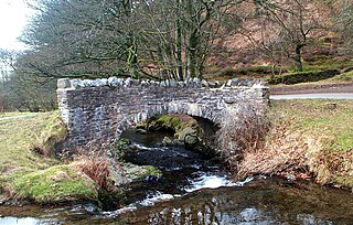
Oare is a village and civil parish on Oare Water on Exmoor in the Somerset West and Taunton district of Somerset, England. It is located 6 miles (10 km) east of Lynton and the parish includes the hamlet of Oareford and the village of Culbone which contains its own tiny church.

Luccombe or Luckham is a village and civil parish in the Exmoor National Park in the English county of Somerset. It at the foot of the moor's highest hill, the 1,750 feet (533 m) Dunkery Beacon, and is about one mile south of the A39 road between Porlock and Minehead. Administratively it forms part of the district of Somerset West and Taunton. The parish includes the hamlets of Stoke Pero and Horner, as well as the former hamlet of Wilmersham.

Cutcombe is a village and civil parish 9 miles (14 km) south of Minehead and north of Dulverton straddling the ridge between Exmoor and the Brendon Hills in Somerset. It has a population of 361.

Selworthy is a small village and civil parish 5 kilometres (3 mi) from Minehead in Somerset, England. It is located in the National Trust's Holnicote Estate on the northern fringes of Exmoor. The parish includes the hamlets of Bossington, Tivington, Lynch, Brandish Street and Allerford.

Wootton Courtenay is a village and civil parish on Exmoor in the Somerset West and Taunton district of Somerset, England. The parish includes the hamlets of Brockwell and Huntscott.

Skilgate is a village and civil parish 5 miles (8 km) east of Dulverton and 8 miles (13 km) west of Wiveliscombe in the Somerset West and Taunton district of Somerset, England. It has a population of 96.

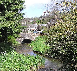
Timberscombe is a village and civil parish on the River Avill 2.5 miles (4 km) south-west of Dunster, and 5.5 miles (9 km) south of Minehead within the Exmoor National Park in Somerset, England. The parish includes the hamlet of Bickham.

Treborough is a small village and civil parish 7 miles (11 km) south of Dunster, lying amongst the Brendon Hills within the Exmoor National Park in the Somerset West and Taunton district of Somerset, England.

The Church of St Peter in Huish Champflower, Somerset, England dates from the 15th century, with the north aisle being built in 1534. It has been designated by English Heritage as a Grade I listed building.
The Church of St Petrock in Timberscombe, Somerset, England has a 15th-century tower, the rest of the building dating from 1708. It has been designated by English Heritage as a Grade I listed building.
The Church of St Nicholas in Withycombe, Somerset, England dates from the 13th century and has been designated by English Heritage as a Grade I listed building.
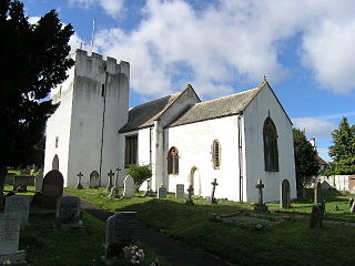
The Church of All Saints in Wootton Courtenay, Somerset, England, dates from the 13th century and has been designated as a Grade I listed building.
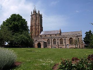
The Church of St John the Baptist in Wellington, Somerset, England, dates from the 15th century and has been designated as a Grade I listed building.

The Old St James's Church is a former church in the village of Upton, Somerset, England, of which only the tower remains, overlooking Wimbleball Lake. The tower is recorded in the National Heritage List for England as a designated Grade II* listed building, and is in the care of the Churches Conservation Trust. The church was declared redundant on 4 November 1971, and was vested in the Trust on 24 May 1973.
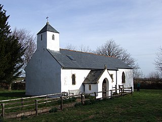
The Anglican Church of St Bartholomew in Rodhuish, Somerset, England was built in the 15th century. It is a Grade II* listed building.

