
Somerton is a town and civil parish in the English county of Somerset. It gave its name to the county and was briefly, around the start of the 14th century, the county town, and around 900 was possibly the capital of Wessex. It has held a weekly market since the Middle Ages, and the main square with its market cross is today popular with visitors. Situated on the River Cary, approximately 8.8 miles (14.2 km) north-west of Yeovil, Somerton has its own town council serving a population of 4,697 as of 2011.

Montacute House is a late Elizabethan mansion with garden in Montacute, South Somerset.

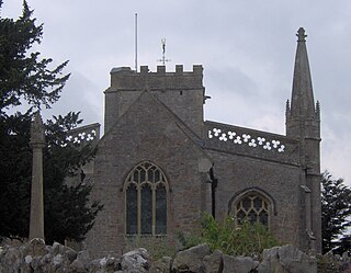
Batcombe is a village and civil parish in the Mendip district of Somerset, England, situated in the steep valley of the River Alham 5 miles (8 km) south-east of Shepton Mallet and 26 miles (42 km) south of Bristol. The parish has a population of 439. Batcombe village is at the heart of the parish, which also includes the hamlets of Westcombe, Spargrove and Eastcombe.

Bishop's Hull is a village and civil parish in Somerset, England, situated in the western suburbs of Taunton in the Somerset West and Taunton district. It includes the areas of Rumwell, Rumwell Park, Roughmoor and Longaller and is close to the River Tone. The parish, which includes the hamlet of Netherclay, has a population of 2,975 in total.

Stoke St Gregory is a village and civil parish in Somerset, England, about 7 miles (11 km) east of Taunton in the Somerset West and Taunton district. The village is on a low ridge of land between the River Tone to the north and West Sedgemoor to the south. The 2011 Census recorded the parish's population as 942.
Williton is a large village and civil parish in Somerset, England, at the junction of the A39, A358 and B3191 roads, on the coast 2 miles (3.2 km) south of Watchet between Minehead, Bridgwater and Taunton in the Somerset West and Taunton district.

Beckington is a village and civil parish in the Mendip district of Somerset, England, across the River Frome from Lullington about three miles north of Frome. According to the 2011 census the parish, which includes the hamlet of Rudge, which has a population of 983, and the hamlet of Standerwick.
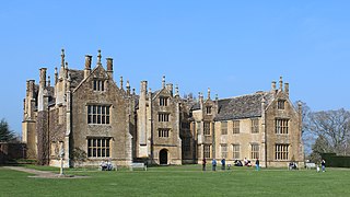
Barrington Court is a Tudor manor house begun around 1538 and completed in the late 1550s, with a vernacular stable court (1675), situated in Barrington, near Ilminster, Somerset, England.
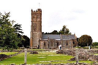
Muchelney Abbey is an English Heritage property in the village of Muchelney in the Somerset Levels, England. The site consists of ruined walls showing the layout of the abbey buildings constructed from the 7th to 16th centuries, and the remaining intact Abbot's House. It is next to the parish church in which some of the fabric of the abbey has been reused.
Burrington is a small village and civil parish in Somerset, England. It is situated in the unitary authority of North Somerset, 5 miles (8.0 km) north east of Axbridge and about 10 miles (16 km) east of Weston-super-Mare. The parish includes the hamlets of Bourne and Rickford and has a population of 464.

Nettlecombe Court and park is an old estate on the northern fringes of the Brendon Hills, within the Exmoor National Park. They are within the civil parish of Nettlecombe, named after the house, and are approximately 3.6 miles (5.8 km) from the village of Williton, in the English county of Somerset. It has been designated by English Heritage as a Grade I listed building.

The Priest's House is a National Trust-owned property in Muchelney, in the English county of Somerset. It has been designated as a grade II listed building. The house was built in the early 14th century by the nearby Muchelney Abbey to house the parish priest.

The Treasurer's House is a National Trust-owned property in Martock, in the English county of Somerset. It has been designated as a Grade I listed building. Apart from the Bishop's Palace, Wells it is the oldest house in the county.

Spaxton is a small village and civil parish on the Quantocks in the Sedgemoor district of Somerset, South West England.

Stoke sub Hamdon Priory is a complex of buildings and ruins which initially formed a 14th-century college for the chantry chapel of St Nicholas, and later was the site of a farm in Stoke-sub-Hamdon, Somerset, England. The only building remaining from the college is a great hall and attached dwelling, dating from the late 15th century. The hall is designated by English Heritage as a Grade I listed building, while the outbuildings and gateway are Grade II listed. The whole site has been scheduled as an ancient monument. A number of the farm buildings are in poor condition, and have been added to the Heritage at Risk Register.
Holford is a village and civil parish in West Somerset within the Quantock Hills Area of Outstanding Natural Beauty. It is located about 10 miles (16 km) west of Bridgwater and 6 miles (10 km) east of Williton, with a population of 392. The village is on the Quantock Greenway and Coleridge Way footpaths. The parish includes the village of Dodington.

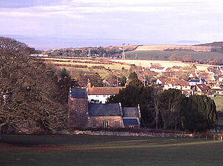
Pitcombe is a village and civil parish 1 mile (2 km) south-west of Bruton and 5 miles (8 km) from Wincanton in Somerset, England. It has a population of 532. The parish includes the hamlets of Cole and Godminster.

The Court House in East Quantoxhead, Somerset, England has a medieval tower and other parts of the building which date from the 17th century. It has been designated as a Grade I listed building.
Dunster Priory was established as a Benedictine monastery around 1100 in Dunster, Somerset, England.

Petherton Park was a Deer park around North Petherton within the English county of Somerset.

